 Hiked Tuesday, November 1. I ventured across Lake Barkley today. Didn't take this map with me, though; I assumed there'd be a visitor center there where I could pick up a trail map. Dumb mistake. It would have let me make better use of my time there hiking.
 Lake Barkley State Resort Park is just a little bit east of Land Between the Lakes National Recreation Area, where I've been doing pretty much all of my hiking the past few months. One thing to be aware of is that there's going to be some construction on the bridge that crosses Lake Barkley in the coming months (possibly years). Today, there was a traffic light that wasn't there last week, with east- and west-bound traffic taking turns crossing the bridge. I don't know how long that's going to go on for, but I have noticed signs on the west side of Kentucky Lake bridge saying that eastbound traffic will be limited to vehicles no wider than 7.5 feet. There are also covered detour signage, directing larger vehicles eastbound on US-68/KY-80 to, instead, head north (west?) on U.S. 68, through Aurora, and towards I-24. If you're coming from the east, of course, this is irrelevant.
From US68/KY80, I turned left, following the sign into Lake Barkley State Resort Park (I assume this is State Park Road, aka KY-1489). I continued straight about three miles, ignoring the road that crossed my route, with the sign for the golf course and trap shooting.
Shortly after that junction, the speed limit dropped from 55 mph to 25 mph, and the road climbed and became windy. I turned right at the sign that pointed towards camping and picnic facilities. Right after I passed the stables (on my right), I saw a sign for the Wilderness Trail, on the right (I later saw a matching sign a bit earlier, on the left, as well). Immediately after the sign was a large water tank, painted white. A Mini Cooper was parked right next to the sign. I took a picture of the car, with the trail sign in the foreground and the colorful leaves in the background. Maybe Mini will someday paying me thousands of dollars to use my picture in an ad. Heh, heh.
The sign said 1.4 miles to the campground pavilion (still not sure exactly what building that was supposed to be).
 This trail was much narrower than the ones I've gotten used to in LBL. Impossible to walk without vegetation rubbing on me--but, far as I could tell, no poison ivy and no ticks were encountered.
After not even 100 yards, the trail split. Blue paint blazes and a sign pointed straight ahead for the Wilderness trail, while no sign and red blazes marked the way to the right and down the hill. I later learned (by looking at the map I linked at the top of this post) that this trail would have looped back around to the stables.
 However, oddly enough, I do not recall seeing the next two junctions that should have been where the Racer Ridge trail would have intersected with the Wilderness trail. Doesn't mean I didn't see them; I just don't remember seeing them.
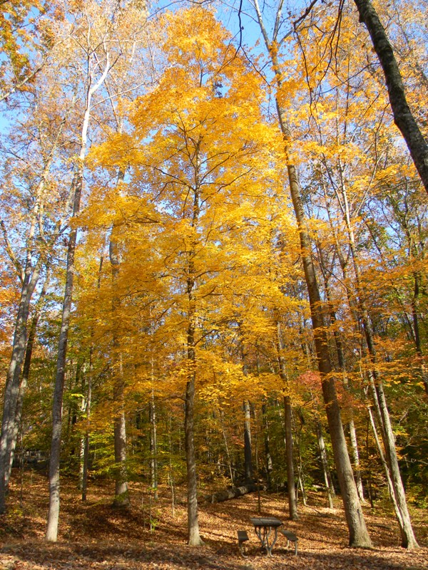
Fall here is well under way, so the entire trail was thick with fallen leaves. Some yellow (and less green and red) remained in the trees, however.
It sure seemed like it was much further than a mile before the trail approached (but did not provide a clear view of) Lake Barkley. During one peek between the trees, I saw two bald eagles flying away.
 With the sun on my left, I clicked off dozens of shots of the backlit yellow leaves. Suddenly, I realized that there was a one-lane road just beyond these trees. Also around then, my trail became less distinct, so I just walked on over to the pavement and walked down that way, instead. An older couple, walking their dogs, were on the other side of the road.
Continuing along the pavement, I reached the end of the loop. Just where I would have started back, I saw a trailhead sign, for the "Wagon Wheel" trail, and an indication that it was .3 miles to the beach. "Sure, why not?" I figured. So down to the beach I went.
 There weren't any cars or people down there. There were a few boats with fishermen not too far off shore. And there were a whole bunch of angry Canada geese, annoyed at having to leave the shore because of an intruder's approach.
Took a few more pictures there. Saw the basketball hoop. Looked across the parking lot, but saw no trailhead signs. (In looking at the linked map, later, I see that there SHOULD have been a trailhead sign somewhere on the other side, but it was not visible from where I stood. So I headed back the way I came.
 Popped back up at the camp ground. There, I noticed a blue paint blaze on a tree, opposite the road from where the Wagon Wheel trail had started. There was no sign on the other side, but there was at least one deer. I decided to leave the deer in peace, and walked back along the road loop, back to where I figured I came.
 Again, in looking at the map after the fact, I can see that this is where the Wilderness trail should have ended, so, presumably, the 1.4 miles was supposed to be by getting here the long way. If the map they provide is somewhat to scale, then I allegedly only went about 1.2 or 1.3 miles from the trail head (although it sure seemed further than that).
Walking back along the road should only have been marginally shorter than returning via the trail, so I'm figuring another 1.2 miles back on the road.
 Once back at my starting point, I first explored the trail that headed west, parallel to the road I came in on. After about 1/4 of a mile, it ran into the stables. In checking the map after the fact, I see that there's actually a 1.6 mile loop that heads out of the stables.
I returned once more to where I started, then crossed the road, picking up the Wilderness trail on the north or west side of the road that heads towards the campground. A sign there said this trail was 1.2 miles. Turns out it heads all the way back to near the lodge.
 I took a bunch of pictures along the way, and also of the bay that's adjacent to the lodge. During the walk down, I passed signs for the Cedar Grove Trail (which, in checking the map, I see should have been on the opposite end of the parking lot from where the Wagon Wheel trail had reached the beach), and the Lena Madesin Phillips trail. The Wilderness trial ended near a swing set.
 Then it was back to the car. 2.4 miles roundtrip on this part of the Wilderness trail, plus .6 miles on the Wagon Wheel Trail, plus about 2.5 miles along the other end of the Wilderness trail and back along the road, plus about 1/2 mile going to the stables and back. That's about six miles, total for the day.
The sun was just setting as I headed back towards Murray. I got stopped at the traffic light on the Lake Barkley Bridge. About five cars and a really big truck were in front of me. Worked out well, though. Great lighting over Lake Barkley, and I saw a lone bald cypress growing on a small island in Lake Barkley. Pulled my camera out of the bag, lowered the passenger side window, and framed and clicked off four shots in rapid succession. The fourth was perfectly lit and composed. That's the picture I stuck at the top of this post.


They traffic signal on the bridge across Lake Barkley were gone as of late-November 2011. The detour signs and size limitations that used to be posted just west of Kentucky Lake on US68/KY80 have also been removed.
ReplyDelete