Monday, July 27, 2015

Hike 2015.055 -- Lower Icehouse Canyon, Angeles National Forest

Hiked Friday, July 17. Even before the most recent rains in southern California, I was surprised to find that water still flowed in lower Icehouse Canyon. I had somewhat ambitious plans at the start of my day, but got lazy and wound up walking only to the wilderness area boundary. 3.6 miles from the trailhead, roundtrip. Maybe another one or two tenths of a mile if you're parked at the bottom of the parking lot, and if you take a number of detours into the creek area to get some water pictures. I'm rounding up to four miles for no particular reason.
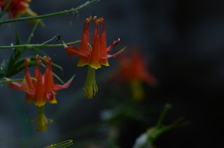
There is perennial water in the canyon, but usually it's just a small seep, between one and one and a half miles up the trail, where water comes in from the left, and maintains a health stand of columbine. So I guess my main goal on this hike was going to be the columbine. That's just the mood I was in. It's only when I saw the water in the creek that I started shooting a lot of creek pictures.

I was starting too late, however, and there was a pretty harsh light and a lot of contrast between the sunny and shady areas. My photos of the water and of the water near a cabin were generally pretty disappointing.
Meanwhile, the area with the columbine was mostly shaded, and, in many cases, left the flowers in dark shade, or under alternating dark shade and bright shafts of sunlight. Very hard to photograph under those conditions.
This was hike 55 of my now-58 hikes of the year. Short hike, but long enough to count as a hike, and a nice add to my daily step count. Add a night shift at the Observatory, and I was well over 20,000 steps for the day.

Wednesday, July 22, 2015

Hike 2015.057 and Hike 2015.056 -- Sturtevant Falls and Eaton Canyon

Well, still more or less keeping on track for a 100 hike year, but well behind schedule in terms of blogging. So here's a two-fer.

After work on Monday and Tuesday, I decided to visit the two easiest front range waterfalls: Eaton Canyon and Sturtevant Falls, in that order.

Because of the relatively heavy rains on Sunday, I thought the falls might be revived. They had been.
Still not exactly roaring, but running well for late-July. Perhaps even a bit stronger than they were in late June. And late June was better than in early May.

It's been a funny rain year--Last weekend's storm put us well above average for July. The early June rains put us well above average for June. May's rains were also at or above average. It's the relative dryness of the earlier months that make it a drought year.
More detailed descriptions of the hikes are elsewhere, including on this blog. Just trying to get something new posted, quick, this time.

Because it was only the previous day that it had rained, Eaton Canyon flowed muddy. I played with some 1/2 and 2/3 second exposures to get some nice blurring, especially at the base pool of the falls.
For Sturtevant Canyon, I added a flag picture. The cabin at Fiddler's Crossing almost always has a nice, newish flag. Nice color in the forest.
Then I have a snap shot (1/20th or so of a second) of the full falls, wide view, then closer views, at between 1/2 and 1/5 of a second, to get the nice blur, again.

Monday, July 13, 2015

Hike 2015.052 -- Lewis Falls, and Crystal Lake Area

Hiked Thursday, July 2. Not my most recent hike, but a relatively recent one to one of the lesser known waterfalls in the Front Range of the San Gabriel Mountains. From the 210 (Foothill) Freeway, exit at Azusa and head north, through "old" Azusa, across the Gold Line tracks, and on into San Gabriel Canyon. Stay on the main road, and observe the mile markers. Long after you've passed the dams and the reservoirs and the East and West Fork junctions, continue just past Mile Marker 34.54.
There's a rusted, metallic Caltrans rock dispenser (you'll know it when you see it). Within 1/4 mile of this point, as you head straight into the "armpit" of a ravine, and you would then need to make a hairpin turn to the left, open your ears. Hopefully, you'll hear the sound of running water.

There's room for about three carefully parked cars at this turn, plus small turnouts on the downhill side, just past the turn, and a small "deadend" driveway on the uphill side.
From there, follow the trail up and around a cabin. Your trail generally stays above and to the right of the water, which is shrouded in thick undergrowth. (It used to be thicker, but a lot of that clutter has been cleared over the past four years).
Apparently, it's been just about four years since my first visit here. Because of the drought, the water's lower than it was on my previous trips. But it's still a nice waterfall.

The silt has also cleared, which makes it a lot easier to get to the base of the falls than it used to be.

The hike still requires some ducking under and balancing over, but it's a short 4/10ths of a mile each way, so it's still a quick and easy hike. But, because of the lack of parking and signage, it's relatively lightly visited. I only saw one other person on this trip.
The falls themselves are in a nice little alcove. The past four years of running water have helped clear the alcove a bit, and make it easier to approach the base of the falls without getting your feet wet (at least in July--might be harder to do during an actual spring melt).
In the alcove, there have always been lots of columbine in bloom. This trip was no exception.

I've also always seen one lily plant on the approach. I used to assume it was a Humboldt lily, but it might actually be a leopard lily.
After this short little hike, I then planned to drive up to the end of Highway 39 and hike from there to the peak that's opposite Smith Mountain. I'd hiked to that peak both from Smith Saddle and from Highway 39 in the past. Unfortunately, the "Highway Closed" sign just past the turnout for Crystal Lake now prohibits, not merely cars, but also bikes and hikers, so you can no longer walk on the road to access the ridge.
So I retreated back to my car, then drove on up to Crystal Lake. I visited the lake (VERY low!), then checked to see if trail access had changed any since my last visit. I determined where I could park to access the trail to Windy Gap, then returned home. The next day, I headed on up to that trailhead for my 53rd hike of the year.

Saturday, July 4, 2015

Hike 2015.046 -- Fish Canyon Falls

Hiked Friday, June 12. I have a growing backlog of hikes to blog, so I should probably post shorter, and just get them done, faster.

Completed my 53rd hike of the year yesterday. It wasn't all that long, but it was warm, and I was getting clumsy on the way down, tripping and shuffling, and slurring my words, a little. So I'm taking it easy, today. Just home, doing laundry, and probably walking around the block in the next few hours.
I think I've been on this hike about three times since the new trail access was opened. It's at the top of Encanto Drive, in Duarte and Azusa. The Vulcan Mining Company owns the land at the mouth of the canyon, and that limited access for years to either a very long detour, or perhaps monthly access across the mining area. Now, there's access nearly every day, with pretty reasonable hours.
It was running a little low last time I came, but that was before a series of rains in May and June sort of gave a lot of the local waterfalls a second spring. I've seen it much higher in the past, as well, but it was still a pleasant sight.

Unfortunately, it was not a pleasant sound, as the folks ahead of me decided they needed a reverberating soundtrack to properly enjoy the outdoors. I don't understand the need for constant noise, because then you'll miss things like the sound of running water. I especially don't understand the decision to make everyone else listen to your music, as well.
The flowers were nice, undoubt-edly helped by the late rains. Lots of buck-wheat, which is to be expected. But the elegant Clarkia was a pleasant surprise.
There was also a fair amount of scarlet larkspur, and a lot of "Our Lord's Candle" yucca in bloom.
I also saw quite a lot (relatively speaking) mariposa lily, and Farewell to Spring. Oh, yes, and a large newt, who was residing at the base of Darlin' Donna Falls.

After visiting the main falls and the accompanying music, I worked my way down to the lower pool. I figured there must be a way down there besides diving, which is common, when the water is higher.

Nice little waterfall there, too.