Saturday, November 28, 2015

Hike 2015.090 -- Hacienda Hills, Seventh Avenue to Nike Missile Station

Hiked Saturday, November 27. 4.5 miles. Late start, and feeling cold, so I wanted something low-altitude. That took me to Puente Hills Landfill Native Habitat Preservation Authority lands, in Hacienda Heights. I used the Seventh Avenue trailhead, at the south end of Seventh Avenue (south of the Pomona Freeway, CA-60).
It was a blustery day, so the air was clear. Great visibility in all directions.

The trail map is here.

I headed on the main trail, which heads south from the trail head, for .3 miles, then turned left at the Coyote Trail, for 1.2 miles, until it meets the Skyline Trail. Along the way, I gained altitude, and could see the white roofs of warehouses and manufacturing facilities in the City of Industry. The Pomona Freeway was visible before that, and the San Gabriel Mountains were beyond that. A scatter of snow had fallen on the higher reaches of the San Gabriel Mountains.
At the Skyline Trail, I headed right (north), and took the trail to the Nike Station. You pass between eucalyptus trees and some pines, which are on the boundary between the old landfill and Rose Hills. There are then switchbacks up towards the station.
As you approach the Skyline trail, you pass under a set of power lines, then approach a fence. Beyond that fence is land owned by Rose Hills; they are grading that land and preparing to expand their cemetery further into the hills.
As I approached the top, I noticed that a trail I had previously seen sign, but had not seen the trail, had been cleared. This added a little juke down to the west, and got a closer view of the cemetery. Maybe an extra 200 yards?
The trailmap does not give a mileage total to the actual Nike Station. However, I would suspect it's at least an additional .5 mile past the Native Oak trail, so figure about 2.3 miles to the Station, then 2.3 miles back. Slightly over 4.5 miles, roundtrip.
Near the Nike Station, and along the Skyline Trail, there are some nice views towards Downtown, and also towards Griffith Observatory and the Hollywood Sign. It feels like this is about 180 degrees opposite Baldwin Hills from Downtown.
The previous shot and the last one are at full zoom (300mm, or 450mm 35mm equivalent). The middle shot is a 50% crop of the one before it. That's just to get a closer view of the Observatory.
Good day to hike.

Unfortunately, I worked last night outdoors, and it got pretty chilly by the end of my shift. Not feeling so hot today, and I have another night shift coming up. Not looking forward to that.

Many hikes to blog, still. This is my last. May try to fit another hike in tomorrow.

Thursday, November 19, 2015

Hikes 2015.080 and 2015.081: Zion National Park

These are all from my "Nevada Day" weekend trip to Zion National Park. Because I went with my wife, I didn't take any longer hikes. We did, however, manage a large number of short hikes, so I still got some exercise in, and, cumulatively, managed two hikes for the weekend.
For you non-Nevadans, Nevada Day recognizes the October 31, 1864 admission of Nevada into the Union. It is now observed on the last Friday in October. Because my wife works for the state of Nevada, I figured we'd be able to build a weekend trip to Zion into the schedule. So I splurged on two nights at the Lodge in Zion: About $250/night, which is kind of crazy for me, but I thought it would be nice to stay in an historic building, and with hiking options available literally right outside the door.
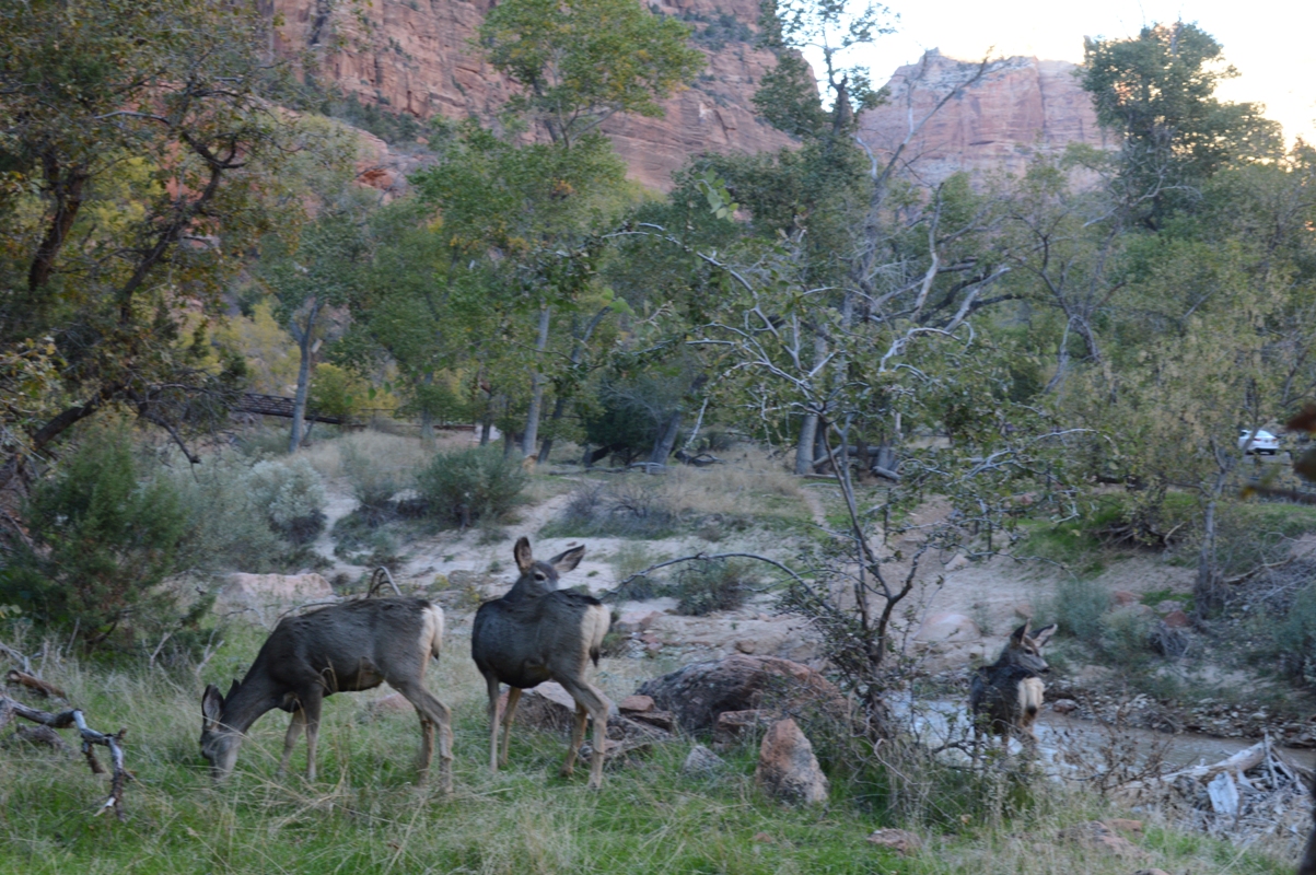
Arrived rather late and hungry on Saturday night, so, after dinner, we had very little time to hike. We ran into a deer before we even made it out of the parking lot, then ran into another pair of deer as we tried to head south on the trail across the river. We then turned around. I continued north to Lower Emerald Pool, then returned to the lodge. About 1.5 miles that night, plus probably 3 more miles just walking around the parking area and sidewalks as I strove to achieve my 15,000 steps for the day (tough, considering I spent nearly the whole day just driving). But I did reach the goal, then called it a night.
The next morning, after breakfast, I stepped outside to literally shoot the moon, "setting" in the cliffs high above. Then we hopped the shuttle bus down towards the Visitor Center.

Zion's visitor center is a little odd. Yes, there are rangers you can talk to. And, yes, there's a really nice bookstore / gift shop there to buy maps and books and what not. But what interpretive exhibits there are are simply signs in the courtyard outside the building. Also, there's no introductory video, which seems to be a mainstay of the NPS experience. Turns out that's at the Museum of Human History, a stop up canyon.
But first, we walked around the VC, where the cotton-wood were beginning to change colors. And we looked for the Archeology Trail. Took some effort to find. It's a short one, just 4/10ths of a mile roundtrip, according to the newsletter. Probably did more walking than that just looking for the trailhead. It's towards the South Campground, in case you wish to find it.

It leads to the foundation of an ancient grain storage structure. No, it wasn't pyramid shaped (Years from now, people will have no idea that this was a joke. Heck, I'm pretty sure that right now, most people won't get the reference!).
Wasn't much there, but it did give us a nice view, both up and down the canyon.

We then returned to the shuttle, and rode that up to the Zion Human History Museum. Not a lot there, either, but they did have the introductory video showing there, so we watched it. It mentioned petroglyphs, so we asked the ranger there if there were any we could visit, and she directed us back near the visitor center. So we hopped back on the shuttle bus and returned to where we had just been. Found the short trail to the petroglypths (probably another 1/2 of mile roundtrip, mostly just getting to the trail and back from the shuttle bus stop), then hopped back on the shuttle bus, to head back up canyon.
After that little hike, road the shuttle bus up to Weeping Rock trail. This is another one that park guide gives as 4/10ths of a mile roundtrip. Additionally, after I returned, I walked maybe another 1/10th of a mile down near the bridge.

Although short, it is pretty, particularly on a fall afternoon. The cascading water drips over a wide cave mouth, and scatters the sunlight that shines into the cave. Also, there was a bit of fall foliage along the way.
All of my walking in Zion up to this point may or may not have totaled 3 miles, or "one hike," by my usual three-mile, off-pavement standard. Definitely, if you toss in the sidewalk walking, I exceeded that.

We then rode the shuttle to the top of the canyon, then rode it back to the Lodge.
After a light lunch or "snack," we headed out, again. This time we both hiked to Lower Emerald Pool. Here (as at Weeping Rock), there were some Big Leaf Maple, Box Elder, and various oaks, as well as Cottonwoods that were turning color.
I had just been up this way the night before. But it was dark. Obviously more interesting when you can see the waterfall.

We returned to the Lodge. I used the restroom, then returned to the trail, heading across the bridge, then downstream, to Courtyard of the Patriarchs. This trail goes along the west side of the canyon wall, and passes under the three patriarchs (rock structures, obviously, overlooking the canyon). Shortly after passing them, it crosses a small creek. After another 1/4 mile or so, it reaches a split, with a short loop that would be walked, were one to continue. However, it was getting close enough to dark (this was the day after the switch back to standard time), so I turned around at the start of that loop, and returned to the Lodge. Probably four miles total on this segment of hiking (From the Lodge to Lower Emerald Pool, then to the Courtyard of the Patriarchs, then back to the Lodge).
Along the segment from the Lodge to the Courtyard of the Patriarchs, I passed a plethora of deer, and a large flock of wild turkey. The deer, you practically ran into on every clearing. The wild turkey were concentrated near what seemed to be a tie-up area for livestock.

Unlike the wild turkey I saw in Land Between the Lakes, these showed no fear. They did not run quickly and silently into the denser forest when they saw me. Instead, they just kept grazing. So I got plenty of shots of them. By contrast, I never got a decent shot of a turkey during my Land Between the Lakes hikes.
On this night and the previous night, we ate in the lodge. I mean, why not? Already splurging on the rooms. Might as well experience the whole Lodge thing.

Food prices are, of course, a little pricey. Figure on $18-25 for most entrees, though usually with a $10 or $12 option hidden away, somewhere. In fact, on the first night, I went with the salad bar buffet, because it included chili as the "soup of the day." Between the chili and bread and all the veggies, I ate very heartily that day.
I also ate heartily the next day, though that was uninten-tional. Because our orders were extremely slow being completed, they gave us the option of starting on the salad bar. Actually, that may have been more my wife, who specifically noted when she ordered that she was hungry and wanted something that would be ready quickly.
She passed on the salad bar, but I loved the salad bar so much the previous day, I was more than happy to go at it again. In fact, I was tempted to just order that again, despite the absence of chili the second night. Just beef vegetable soup. Instead, I went with the Navajo taco. So when the offer came to head back to the salad bar, while awaiting our entrees, I was happy to oblige. It did not disappoint.
By contrast, the Navajo Taco did disappoint. A Navajo taco is basically an opened-faced taco or tostada, but made on Navajo fry bread instead of a tortilla. At least, that's the way it's supposed to be made. Fry bread is, as the name would imply, fried. It's dough, deep fried, and so usually puffy and soft. My Navajo taco, however, tasted like it was built on top of pizza crust. It wasn't bad as far as food was concerned, but it did not taste like a Navajo taco is supposed to taste. it wasn't fry bread. It definitely wasn't as good as the little diner in Chambers, AZ, which we had visited during last fall's trip to Canyon de Chelly.
Three hikes from that trip, by the way: first, second, and third.
The Canyon de Chelly trip was a lot of fun. If I had to rank it, I'd say I had more fun on that trip than this one. But it also required 3 1/2 days of really serious driving, albeit broken up with some nice little surprises (the little mining town in western AZ, Winslow, and Meteor Crater) along the way.
The idea for this trip was to be more relaxing: Two long days of driving, but two nights in the same room, with entertainment (in the form of hikes and what not) starting right outside the door. Very different kind of trip.
So I guess there's something to be said for just making random stops on a long drive, though with the trade-off of being more tired at the end of the trip than at the start.

Can't say I wouldn't want to do this, again. Yeah, maybe in the summer, I'd be willing to camp. But, by the end of October, man did it get cold at night!

And, in fact, the next week, the highs were down in the 40s, as opposed to the mid-60s when we were there. Also, the scenery is beautiful, including at night, and, especially, at twilight. So maybe again next year, or in the spring. We shall see.
On the way out of the park, I stopped at Canyon Junction. If one were driving through the park, towards Mt. Carmel, they'd go straight, instead of turning north, into Zion Canyon.
Here, the canyon opens up, and there's gorgeous views in all four directions. Stained on to one of the walls is a figure that looks a little bit like Darth Vader. I mainly stopped for that, but enjoyed the views down and across the Virgin River.
This required no more hiking than crossing a bridge, but it still yielded some nice photos, and another national park moment.

So, a lot of short hikes on this trip, totalling 6-7 miles for the weekend. I made well over 30,000 steps on that full day in the park. My wife broke 10K, which is good, for her.

Tuesday, November 17, 2015

Hike 2015.086 -- Eaton Canyon

Hiked Tuesday, November 17. Got off unexpected early today, so I had time to get a hike in. This one was number 86 for the year. I still remain well behind on my blogging. However, I am more or less on schedule for my hiking. If the weather holds through November, I should manage at least five more hikes, giventhe holidays and weekends that remain. That would leave me with 9 or so to do in December. Given the weekends and formal holidays that remain, I should be able to get those hikes in, but it will require some discipline and some luck with the weather.

This hike's been done by me many times. But it's convenient--among the closest possible trailheads, and almost always with at least some water to give the hike some interest. It's also about four miles long, which means I can fit it in to any 3 or 3 1/2 hour block of time I may have. In this case, I arrived near the Nature Center (off of Altadena Drive, just north of New York Drive) about 2:30pm. That means about two hours before sunset. Given that the parking lot is supposed to close "at sunset," that meant there was some chance, if I got hung up along the way, of not making it back before the gate got locked (assuming it was locked on time). To be safe, I took the precaution of parking on the street.

It's another two days or so before the First Quarter moon, so there was a fair crescent visible from the start of the hike. As I entered the canyon, the sunlight still hit the west canyon walls, but the sunlight was well off the floor.

There are some powerlines that cross the canyon. I thought it would be fun to illustrate the cause behind the phases of the moon by shooting one of those balls at almost the same angle relative to the sun as the moon. And, as expected, the "phase" of the ball was, in fact, pretty much the same as the phase of the moon.
Not a lot of fall color down here, but there are a few sycamore. I shot some of their leaves, as well. And there are shots of the leaves of the ground, in front of the falls.

Pleasant weather. Funny thing about this canyon hike I've noticed is how, as you walk down the canyon, you may be periodically hit by warm, then cool air. Microclimates are a funny thing.

As for the waterfall, I also shot plenty of shots, including both the full falls and close-up details of the falls, themselves.
Because of my slow pace, with many stops for pictures, the sun set well before I got back. It was getting dark. I heard the sound of the gate being moved as I made my way past the parking lot. Not sure if they actually had it locked, or if they just close it, but allow late returnees to push the gate open to leave, while deterring late-comers from parking. Either way, I was happy to have parked on the street.

About four miles for the day. Well over 15,000 steps for the day, too. ;D

Tuesday, November 10, 2015

Hike 2015.082 -- Oak Glen Preserve

Hiked Friday, November 6. One hike ago, and the most recent not yet blogged. This was a short hike I have done many times before. However, I was surprised to discover that I hadn't been up here all apple season!

As I suspected, I was too late for fall color. Looks like it was a pretty poor season for foliage up here, as well.

Still, Oak Glen Preserve is always a nice little hike. It's got a nice mixture of micro-ecosystems, which makes for year-round interest.
On this day, I started a bit late, and I was hungry, so I decided to eat one of their tri-tip sandwiches. they have a barbeque going most apple season, but I usually am not here long enough to need to eat a large meal. So I had often sniffed this, but never eaten it.
It's a little pricey, something like $11 for a tri-tip combo (with a small side and drink). The sandwich, however, was very tasty. It was on a french role that they buttered and toasted, so it was dripping in fat even before you added the meat. Yes, very good, it was.
After lunch, I hit the trail. For no particular reason, I walked it backward. In other words, rather than entering via the entrance to the Preserve, I headed due south from the parking lot, and entered via Oak Knoll Park. Lots of picnic benches and several rows of white folding chairs beneath the oak boughs, and in front of a little arch that looked prepared for a wedding.
I continued on down the path, passing south of the developed area, then continued on up the Preservation Point trail. This is a short but somewhat steep trail that takes you to a wonderful overlook of the whole Oak Glen area, as well as much of the Inland Empire. It was a little hazy, but still a nice view.

Then, back down the Preservation Point trail, and up the Stream Trail, to the small pond. Then, from there, back to the parking area.
It's about four miles for the whole thing. Not very long, but a nice Friday for me.

Oak Glen is accessed from either the 10 or 210 freeways. From I-10 (the San Bernardino Freeway), exit at Yucaipa Blvd, then turn left at Oak Glen Road. Follow Oak Glen Road into the town of Oak Glen. Riley's Los Rios Rancho is the home of Oak Glen Preserve.

From the Foothill Freeway (I-210), exit at San Bernardino Road and head east. After a several long blocks, take Orange Street south (right) to Citrus St (CA-38). Take CA-38 about four miles east, to Bryant St (just before the ranger station). Take Bryant Street about two miles east to Oak Glen Road, then turn right, to Oak Glen.

At the southeast corner of Oak Glen and Bryant is a Rite Aid. If you've forgotten any sundry items (batteries, SD card, sun block, water, etc), that's a good place to get it. There's also a Stater Brother's supermarket, on the northeast side of that corner.

Sunday, November 8, 2015

Hike 2015.083 -- North Etiwanda Preserve, Rancho Cucamonga, CA

Hiked Sunday, November 8. Most recent hike; still many older hikes to blog.

North Etiwanda Preserve as at the north end of Day Creek Blvd. From I-210 (Foothill Freeway), just west of I-15, take the Day Creek Blvd exit and head north approximately 2 1/2 miles.
There's a sweeping turn to the right as you approach the final develop-ment before the trail area.

There are no restroom facilities at the trailhead. There is a pit toilet approximately one mile along the loop trail if you start counterclockwise, or two miles along the way if you go clockwise.
Alternatively, there are restroom facilities at Day Creek Park, two blocks north of I-210. Park at the end of the pavement.

Shortly after the end of the pavement, there are two locked gates, one to the north and one to the west. Those are the two ends of the 3.5 mile loop that traverses the Preserve. Within the preserve are several exhibits that interpret the historically significant remains in the Preserve.

To get to the waterfall, head around the north gate. After a bit more than one mile (distance markers are on the loop at 1/4 mile intervals), you'll reach a multi-directional split. The loop trails would head west. There's a picnic area, a bit to the east. On the other hand, if you go straight, you'll be on the path to the waterfall.
After 1/2 mile or so, there's a water infrastructure object, on your right. If you pass to the right there, there's a short but (soon) very steep trail that drops to the base of a small set of waterfalls. Take care if you choose to descend this trail, taking care to minimize your impact on erosion by stepping on stones rather than dirt, and using tree holds and rock holds to keep from impacting the dirt that retains the rocks and plants.

There's a disappointing but not surprising quantity of graffiti down there.

Return to the main trail. Once there, continue further up-canyon. In another 1/8 of a mile or so, you'll reach the top of a set of waterfalls. There'a narrow canyon that links the two sets of waterfalls, which is pretty impossible from the safely-accessible top or bottom.
I visited in early November, during a period of about five months of above-average rainfall, but that followed a multi-year drought. I'm not sure if what I saw was typical or not, but I get the feeling that, because of the faults and water paths in this area, running water is going to be there far more often than not.
Return back to the main trail.

From what I have seen, it's about 3.5 miles roundtrip if you go from the parking area to the falls and back.
On the way back to the loop, trail, you may observe there was a fork that you passed while heading uphill. The left trail peels off and becomes a more distinct fireroad that soon heads to the west. That path would also take you back to the loop, but via Day Creek Canyon.
If you instead continue back to the main loop trail, you'll still be heading west. In this case, however, there are informational signs and mileage markers along the way. That's the way I went, anyway.
After 3/4 of a mile or so, I reached the chimney and metal frame that represented an historic cabin. After the cabin, the trail soon begins a westward run, until you reach the large detention basin for Day Creek. From there, the trail then heads south.
You'll reach a nice overview with signs that include panoramic photos, labeled with the various sights in each direction.

The trail then heads somewhat to the east, then south, and includes an overlook of what is described as a marsh. This whole area looked relatively well-covered in foliage for the area, which is probably due to a high water table that made this place a target for early water development in San Bernardino County.
After the marsh, it's a bit further south, then a long easterly walk, between a pair of powerline structures that lead you back to you the parking area.

Somewhere between 4.5 and 5 miles total for the hike. Moderate climb on the way to the falls, then largely level, then a descent. The weather on my hiking day was comfortable. This area can obviously get hotter and windier than it was, in which case you'll want to make sure to have lots of water.