Thursday, March 31, 2011
Desert Wildflowers Move Into High Gear
Sounds like views are peaking in the area just south of Joshua Tree National Park. The Theodore Payne wildflower hotline report for last week is here. A few hot days like yesterday and today and that'll dry things up pretty quick, so this weekend is probably prime viewing. I may try to get out there early next week, combining some astronomy at night with wildflower viewing in the day. Haven't decided if it's time to buy an annual pass or American the Beautiful Pass, yet.
Cosmic Cafe Reopens April 1
Good news for folks making their way to the top of Mt. Wilson this weekend: The Cosmic Cafe will be reopening on Friday, April 1. There's something really cool about being able to eat someone else's food and drinking someone else's refreshments after a long hike.
The cafe is usually open only on Saturdays and Sundays, from spring through fall. It also opens on certain holidays and other occasions.
The cafe is usually open only on Saturdays and Sundays, from spring through fall. It also opens on certain holidays and other occasions.
Wednesday, March 30, 2011
Hike 2011.020 -- Fish Canyon
 Hiked Wednes-day, March 30. I initially planned to hike this either Monday or Tuesday, but I went and substituted a hike in Whitewater on Monday, and on Tuesday, I forgot my camera and didn't feel like heading back out here after heading home. I would have preferred those other days because this is a long and tough hike, and not something you want to do when it gets hot.
 I think this is my third time doing Fish Canyon the long way. I also did it once the easy way.
The easy way is obviously quicker. It's about 4 miles roundtrip of hiking, with only a few steep gains and a net gain of about 700 feet going. But it can get way too crowded for my taste. All that pent up demand between shuttle days means when Vulcan (Azusa Rock) runs their shuttle vans, the vans tend to be full. In theory, regular, 7-day a week access by foot is coming, since it's one of the conditions in the new development agreement Vulcan has with Azusa. That may be a while coming, however.
 The hard way is a bear of a hike. You need to make about a 3,000 foot gain to work over and around the current Vulcan Mining operation, both coming and going. In theory, this route will be obliterated once Vulcan moves their operations to the west. When the mining shift (and regular access via a low route) will occur depends in part upon the litigation surrounding the new development agreement.
 To get to the trialhead for the long hike, take the 605 freeway north to Huntington Drive. That's at the end of the freeway. The second lane from the left will take you there. Make a right at Huntington, and head east for just under one mile. After passing Las Lomas, the next left will be Encanto Parkway.
Head north on Encanto Parkway. After just over 1/2 mile, you'll pass Encanto Park, on your left. If you need to use the restroom, go there, because there aren't any restrooms at the trailhead or anywhere along the trail.
 There's also the Duarte Museum there (777 Encanto Pkwy, Duarte, 91010). I mention this because on Sunday, April 10, I plan to join my friends in the Old Town (Monrovia) Sidewalk Astronomers there for a public star party. Weather-permitting, we should get a nice view of Saturn and the moon. If we're there late, we might try for a few deep sky objects, but usually for urban events we just stick with brighter objects. We start around dark, after folks who came to the Duarte Chamber of Commerce potluck are done eating.
 About 1/2 a mile past the park, you'll pass the last of the houses. The road will get narrower and rougher. Shortly after a dirt road (Van Tassel Mountainway) headed off to the left, you'll see a small (unmarked, unpaved, unsigned) parking area on your left. It's surrounded by mounds of dirt pushed around the lot by bulldozers. Park there.
 The actual trail begins on the northwest end of the lot (that's the back right, if you're facing the lot from the road). You cross on a small wooden walkway, then head towards a display board with some trail information. Continue to your north. Right around here this morning, I saw a little bunny rabbit.
 As you keep walking, you'll soon find yourself with a chain link fence immediately on your right, keeping you out of a horse boarding and exercise area. Dogs will probably bark at you as you walk by.
 Next, you start to climb. And you'll do a LOT of that on this trail. Even worse, you'll probably want to do this hike wearing long pants, since there's LOTS of poison oak along the trail, unless you come in the dead of winter, when poison oak drops its leaves. There were also some poking thistle along the trail ("Poking" here is a verb here, not the proper name of the plant!).
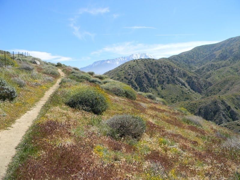
 On the positive side, there were plenty of flowers blooming. Mustard, daisies, sunflowers, thistle, sage, Canterbury bells, lupine, California poppy, and morning glory, chia, and blue dicks were common on the way up. Monkey flower were visible in the "jungle," the heavily overgrown area that breaks up the climb up. I also saw blue larkspur once I got near the river, as well as other flowers I didn't recognize.
 Also on the way up were several nice views of the snow-covered mountains to the east: Mt Baldy, Mt Cucamonga and Mt. Ontario, among them. Some views were framed by flowers. All views showed what seemed to me to be a crazy amount of snow for being practically April. Depending on how hot it gets in the next few weeks, as well as if we get any more snow it could be well into June before the summit is clear.
 After the long climb, you eventually reach what feels like a little depression in the path. It's obviously a moister area, as the growth tends to be thick. This is also where you'll run into your first poison oak, which will often grow right adjacent to or over the trail. It's almost impossible not to rub against it as you walk, so long pants are a good idea.
 When I reached the jungle today, I was accomp-anied by a turkey vulture, who kept riding the thermals above this ridge.
 When you pop out of the jungle, you are then walking along a chain link fence. Walk along that fence for a few hundred yards. Then the trail curves to the left, and begins another significant climb. Finally, you'll pass between a gap in another fence. Shortly after that, your're over the ridge, and making a long descent back towards Fish Canyon.
For the math to work out, the entire climb and descent is just three miles each way. But it is a 3,000 foot net gain, so it feels a lot further.
 You are now on the regular Fish Canyon trail. From here, it's less than two miles to the waterfall. With the water not far below you, however, the trail now begins another ascent. It's nothing compared to what you've already done, but because you've already done it (and you know that big hill is waiting for you on the return), even these smaller gains can be demoralizing.
 Nonetheless, at least now you are often able to look down at and hear the rushing water, so I suppose it should feel cooler. The foundations of several cabins and walls are visible from here on in, just in case you want to make some detours.
 About a mile in, there's an interesting "spiral staircase," where the trail makes its way between tree branches. Shortly after that, there may be a small amount of water crossing the trail. If there is, you can take a short detour to the left here. Darlin' Donna Falls is up that way, less than 100 yards from the trail, but completely invisible without getting off the main trail.
 Less than 1/2 mile past there, you cross the main portion of Fish Creek. Or at least, you do if you want to make it to the falls. Depending on the volume of water coming down the creek and your confidence in your own sense of balance, this may be easy or hard.
 As you contemplate your way across the water, take a look upstream. If it's early season, there may be a thin fall of waters, coming down the canyon face, on your left.
Once across the river, it is again less than 1/2 mile before you reach the end of the road.
 Fish Canyon Falls deserves the "s," because there are multiple falls here. You can walk right up to the pool of one of them. Two others are above this "main" falls, although one is semi-invisible, depending on the angle you're looking at it. A fourth falls drops from the pool of the main falls.
Any one of them would be quite a sight in the San Gabriel Mountains. Having all four here together (plus, potentially, Darlin' Donna and the unnamed falls near the river crossing) makes this one of the special places in the local mountains.
 After enjoying the falls, I headed back. I wasn't looking forward to this, because I brought less liquid to drink than I intended (a byproduct of doing the Whitewater hike on Monday and being too lazy and too stubborn to toss another bottle into my backpack). As it was, I had only a quart to drink, which is 1/2 what I should have brought.
 When I got back to my car, the car thermom-eter said it was 88 degrees. I stopped at Encanto Park to fill up my bottle with water and splash some on my face. That helped, but I know I should have brought more to drink. The fact that the weather was even warmer than I expected didn't help things. It was way too hot to be doing this hike today.
Monday, March 28, 2011
Hike 2011.019 -- Whitewater Preserve
 Hiked Monday, March 28. It's a sad and pathetic story to explain how I wound up here today. Not that I minded hiking here; it's just the explanation is ridiculous. So I'll skip it.
 The park is accessed off of I-10, about eight miles east of Cabazon. Exit at the Whitewater exit. If you're coming from the west, it's shortly after a roadside rest area. After you exit, turn left. The road takes you over the freeway, then heads east. When you see a sign that says straight ahead is not a through street, it's time to turn left. A sign for Whitewater Preserve should also be there, pointing the way. Follow Whitewater Canyon Road about 4 1/2 miles, to the end of the road.
 I've hiked Whitewater Preserve on two previous occasions. The first time, I hiked from the ranger station to the Mission Creek Watershed. The second time, I hiked from the Cottonwood trailhead to about 1/2 mile into the Whitewater watershed. Today, I hoped to hike from the park headquarters to the Mt. San Gorgonio Overlook. That should be about 6 1/2 miles each way. The weather was perfect for hiking--low 60s when I started, upper 60s when I finished. Unfortunately, high water foiled my plans at several points.
 My first serious water encounter was about 1/2 mile from the park head-quarters, while I was still driving in. At this point, the road has a depression built in, designed to allow high water to safely flow over the road.
 I decided to park just south of the water crossing, and attempted to walk upstream, looking for a dry crossing. After about 1/3 mile, I gave up and headed back to the car. I changed into shorts (I was planning to do that at the park hq), took off my boots and socks, and walked carefully across the section of road that was underwater. The water was up to 18 inches deep, but most of the way it was just 6-8 inches. I brought my Sham-wow to dry my feet before booting up, again. As I sat on the other side, several other people also splashed their way across, while one passenger car drove through the water.
 Clearly, the water was passable, but I just didn't like the idea of driving through that water. The water was well-below any air-intake parts of the engine, but it sure looked like it would be high enough to seep under the door (which isn't waterproof, after all). Nonetheless, when I got to the preserve parking area further up ahead, a number of cars (mostly SUVs, but some passenger cars) were already there.
At the same time, there were many cars parked on the south side of the water, where I parked. I guess it depends on how lucky you feel or how chicken you are. Cluck, cluck.
 Once across the water, I walked the 1/2 mile to the park hq, and signed in. No rangers in the area, but I did talk to a few hikers who were coming back down the trail. They said that if someone wanted to cross the water, they had to expect to get wet well above your thighs.
 Well, true or not, I figured I was already here, so I was definitely going to do some hiking on this side of the water. I pretty much figured I wouldn't try the San Gorgonio overlook hike, though. That would have required crossing the river twice.
 I followed the trail past the PCT mileage signs and between the twin palms at the start of the trail. Before long, I was at the crossing. The river here was actually about four separate streams. Some were no more than ankle deep and could easily be walked across. Others were deeper and swift and would definitely get me wet.
 After crossing two constructed foot bridges, I came to a section of water that seemed too deep to cross without getting wet. I retreated and explored further upstream, eventually walking another 1/2 of a mile upstream, looking for an easier crossing. At one point, a narrow tree limb seemed to provide a crossing. But it was thin, I'm fat, and the water below was deep and swift. A fall would mean a real soaking and a dead camera. I continued past that limb for quite some time, looking for possible walking sticks to help in the crossing. But even when I came back down with a walking stick, the crossing looked unnecessarily precarious. If I REALLY wanted to cross, I should just find a flatter area and take off my shoes, again.
 I turned around and headed down-stream. When I got back to near the foot bridges, I saw a couple of older hikers have a seemingly easy way quickly crossing the water. Hmmm, that was weird. So I made my way back across the two bridges and the other easy crossings and came again to the one that was too deep and wide to leap across. A little more exploring and I found another way that still required a little bit of walking around in mush and a little bit of leaping, but still got me on the west side of the Whitewater River with my socks mostly dry.
 After just 1/3 of a mile or so on the well-defined trail, I came to the signed junction with the Pacific Crest Trail. From there, heading straight takes you to Canada. If you don't want to go that far, you can go another 1 1/2 miles to Red Dome, 6 miles to the San Gorgonio Overlook, or 7 1/2 more miles to the Mission Creek Preserve.
Alternatively, turning left here sends you to Mexico. It's also the way you'd go for the Canyon Overview Loop trail, or to head back over the Cottonwood Trailhead, or on down to the Haugen-Lehman offramp of I-10.
 I went left. Last time I was in the area, I had taken the Cottonwood Trailhead, over into the Whitewater watershed. But I did not go as far as the Canyon View Loop. This section would be new.
Heading up this way, there are plenty of switchbacks and plenty of wildflowers. You also get nicer and nicer views of the Whitewater watershed, a peek at Mt. San Gorgonio, and plenty of good views of Mt. San Jacinto.
 After a brief climb (maybe 6/10ths of a mile), a signed junction for the Canyon View Loop directs you to take a left, off the PCT. The trail then runs mostly level and to the southeast, parallel to the river, though, for most of the way, you are well away and not in view of the water. The last bit (for me) was a switch-backed descent, back to the Canyon Road.
 The Wildlands Conser-vancy (which owns and manages the preserve) says this loop is 3 1/2 miles in length. Since I also did a few detours while trying to cross the water twice, I'm figuring I covered 4 1/4 to 4 1/2 miles, total. Pretty short, as far as most of my hikes have gone (except recently!). I suppose if I was feeling a little more ambitious, I could have headed all the way up to the saddle separating the Cottonwood and Whitewater watersheds before heading back down. Definitely, had I made an earlier start and not had such a difficult time actually getting started on this trail, that's what I would have done.
 Whitewater wash looks very desolate, just 'cause it's so white. There's some interesting structure in the mud-stone that comprises the cliffs to the east of the Whitewater River. Also, in the north-facing slopes of the cliffs on the west side of the river. Spring flowers also add a little color, but they're patchy. Much of the plant growth is otherwise grey--sagebrush. This means the landscape is somewhat washed out.
 In areas where the trail crosses the wash, there are often logs or yucca stalks that are erected and held up by piles of stones. If you feel you're off the trail, you can look around to see if you can see any of these markers. They may help get you on the right track.
 Despite the bland coloring of the wash, there are some great vistas on this trail. One of the overlooks is right over the visitor center, so you get a birds eye view of where you were. As noted earlier, you also get to see San Gorgonio and San Jacinto. You can also look down the Whitewater River, towards the Coachella Valley.
  Also interest-ingly, I could see the canyon road where the river ran over the road, and I could watch cars crossing the water from about two miles away.
The first video below is of the Whitewater River, as it flows over the Canyon Road. It sort of looks like Horseshoe Falls, to me!
The second video provides a bit of an overview and a sense of scale to the Whitewater watershed.
Friday, March 25, 2011
Hike 2011.018 -- Rubio Canyon
 Hiked Friday, March 25. I've been doing a lot of nearby (for me) waterfall hikes recently. That's a result of several things: 1) Lots of rain, which means high water flows down the various falls; 2) Lots of days when rain threatens, which means I don't want to drive too far or hike too long; 3) No Adventure Pass, which limits my choices until I eventually splurge on the pass; 4) Rain also means the trails in the Puente Hills are often closed, waiting for the 48 hours without rain or threat of inclement weather. That eliminates additional nearby trails I might otherwise be using.
Today, I kept watching the weather. When I was sure it was going to hold dry for the rest of the evening, I decided to go. That, and I was sitting around munching on way too much junk food. Best way to stop eating is to go some place where there isn't any food, and to be busy enough doing something so you don't miss it. Hence: HIKING!
I've written up my hikes in this area several times this year already, (and also a few times last year) so I'm leaving out many details of the hike. I've also included pictures of all of these waterfalls before, but you might be curious, just to be able to compare flow levels at different times.
 However, one that was new since my last visit was what looked like a trail register. It was on the left side of the trail, just past the house, with the letters AFC on top. Inside were flyers for the Arroyos and Foothills Conservancy, and a sign-up sheet for their e-mail list. There were also some of the black and white, photocopied, hand-drawn maps of Rubio Canyon in there.
I grabbed one of the AFC flyers, but now I can't figure out where I put it. I know it was in my pocket when I got back to my car, but I can't find it in the car or in the house. I'm sure it will turn up. In the meantime, here's a link to their home page.
 The water was roaring nicely in the ravine as I made my way towards Moss Grotto and Ribbon Rock falls. There was noticeably more water coming over their lips today than the last time I was here, but they're still relatively modest waterfalls.
 From there, I headed up the ravine to the right, passing to the right of two trees before looping back around to the left and following the trail to the Thalehaha Falls overlook. Took some pictures and video, then headed back down and took the detour to the top of Moss Grotto Falls and the base of Grand Chasm Falls. More pictures and video there. Grand Chasm is pictured at the top of this post, while the video I shot looking over the lip of Moss Grotto is at the end of this post.
  It was just about 5pm when I got back to the base of Ribbon Rock Falls. This time, I noticed a rock outcropping protruding high above Moss Grotto. The rock overhand looked a little bit like a bird in flight, so I took another picture. Next, my plan was to head back down the creek, then take the trail up to Echo Mountain. Time was running short, but I thought I might still have time to finish this.
 The trail up to Echo Mountain from this side begins by steeply switch-backing up along the old rail grade. Poison oak is common near the bottom. As you climb, you'll pass beams of wood and random rail segments, as well as several areas where the remnants of rock and cement footings remain.
 After about 1/4 mile of steep climbing, you get a pretty good view of what I think its Moss Grotto Falls. There's a wider view here, where you can look up the canyon a bit. Below is a closer look at Moss Grotto.
 After another 1/4 mile, the trail leaves the rail incline and begins a long traverse to the northeast. After yet another 1/4 mile, the trail to Echo Mountain begins climbing, again. However, at the same point, a clear use trail breaks off to the east. Partial views of Leontine Falls are visible from this split, and you can see that the trail heads towards a promontory that promises a nearly unobstructed view of Leontine Falls and the two unnamed cascades above it.
 I took this detour, which is probably about 1/5 of a mile each way. In some spots, you've got to duck under trees and shrubs. You also have a few good views to the northwest, into another drainage that, today at least, had a roaring river with additional cascades in view. This would be Castle Canyon, which I attempted to explore a few weeks ago.
 From the tip of the Promontory, the view is quite impressive. With the exception of a large tree near the base of Leontine, the falls is completely unobstructed. You can also look down stream at some very narrow canyons that contain Rubio Wash. You can also see the outcropping where you can view Thalehaha Falls, although the falls themselves are not visible anywhere along this trail. I'm wondering if there might be a cross-country route to view them from the west. I'm thinking not, since those falls are within a narrow slot that faces almost due south, and is well-guarded by canyon walls on the other three sides.
 With the amount of time I spent taking pictures and videos and enjoying the view, I no longer felt I had time to make it up to Echo Mountain and back to my car before dark. So, when I got back to the trail, I took it back down to Rubio Canyon, instead. Made good time heading downhill and avoided the poison oak near the bottom. I was back in my car at 6:50pm. That's an hour and 50 minutes after I left the base of Ribbon Rock Falls. I did stop numerous and lengthy times to shot pictures and video, but I doubt the cumulative stopped time was more than 30 minutes. So I'm figuring at least 3 miles of walking from the falls. Figure 3/4 of a mile to get there and at least 1/2 mile from there to the Thalehaha Falls overlook and back. My best guess is 4.25 miles of walking for today, give or take 1/2 mile.
The video I shot over the edge of Moss Grotto Falls is below. When you watch the video, note that there's a person you can see near the center-top of the video near the end. He's standing some distance away from the base of Ribbon Rock. That helps put some perspective on the video, because Ribbon Rock isn't even very obvious when looking from the top.