Hiked Tuesday, June 2. It's been a week since my last hike, and obviously much longer than that since my last post. I keep hoping to be able to catch up on that, but it's been hard to fine time to even sort the photos, never mind actually writing the posts.
This last one was relatively short, but with an added twist to make it a little different.
As I've written before, the Altadena Crest Trail runs along the foothills above Altadena. It starts at the mouth of Eaton Canyon, just west of the bridge. It heads to the west, lands goes over pavement for a short segment near the mouth of Rubio Canyon, then heads up to the start of the Sam Merrill Trail. It then continues a bit to the west before petering out just a mile or so west of Lake Avenue. There are also several segments around Cheney Trail, and also down near the Arroyo Seco.
I chose the Tanoble access because it added a bit to the hike without making it too long. I just wanted to exceed my arbitrary 3-mile rule, which I'm sure I managed for this round trip.
There are several good climbs and descents on the way to Eaton Canyon. Once there, you have to cross the bridge, loop downstream a bit, before passing back under the bridge. Along the way to Eaton Canyon, you're high above the backyards of many Altadena homes.
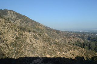
You've also got nice views across the north San Gabriel Valley. Rather interesting to me was that the canopy of trees above the houses almost made it look like you were overlooking a forest rather than an urban area. From the lower angle, the treetops almost completely hide the streets and homes. Oh, sure, you can see them, but it looks like it's more forest than city.
There are still some wildflowers blooming, through not a lot. The only one I photographed here was the scarlet larkspur. They're still rare enough to be seen by me that I get a kick out of when I do see some.
In addition to that, there's a fair amount of Spanish broom, along with some Canterbury bell, and a smattering of other flowers, both wild and domestic.
Usually, I have the Altadena Crest Trail pretty much to myself. You'll see people, of course, but there's far more time alone than in sight of other people.
That also means it's pleasantly quiet, most of the time. It's always a little sad when I have to hike among people who have no regard for nature. They'll fling rocks up cliffs and at other rocks, and whack sticks against rocks until they break. Yes, I saw that on my hike. And we're not talking 12 year olds--these are folks in their late teens and twenties. They should know better, and even if it makes me sound like an elitist, I don't like it. And I don't like all the empty water plastic water bottles and potato chip wrappers I pass along the way.
I like to think that, given enough time in the quasi-wilderness, a wilderness ethic will take hold, and these kids will start learning to spend a bit of time in awe of their surroundings, rather than thinking of it as their own living room, to do with as they please, their fellow hikers be damned. But I have no way of knowing if they'll eventually change, or they'll change the norm of how people treat the wilderness-urban interface.
Anyway, aside from all that, the water was still running. These crazy May (and, now, June) showers have kept the water going a bit. It's still pretty low for spring, but better than it was in late winter. And I can still find a spot to get comfortable and take 1/3" to 1/4" exposures to get the nice veils of water on the various falls and rapids along the way.
And, of course, even in the canyon, there are moments of quiet, at least on weeknights. Not always possible on weekends.
I returned the way I came. Probably four miles roundtrip, possibly more. The return hike actually took a little longer than I thought it would take. Something like an hour each way, which, even at a slow pace, should be well over 4 miles, total.


