Pages

Saturday, November 19, 2022

Kolob Terrace Road, October 10, 2022

Mostly just a drive, although I parked the car and walked around taking pictures enough to accumulate over 10,000 steps on the drive. The first shot was at my turnaround point, with a nice view in all directions and grazing sheep in the fields around me.

The second two were very near a spot I stopped a number of years ago. I guess it always lights up and looks great around now. Same as last time, it triggered a "Wow," and I had to stop. Someone else was shooting family shots in the same area, and I tried to stay out of their way.

Kolob Terrace Road breaks from UT-12 while still early in the canyon, and heads along the west end of the terrace, overlooking the valley that is home to Cedar City. Spots of color stopped me on the climb, but the real show as after the road leveled out, beyond the front, and started weaving within the aspen. Small homes and cabins were scattered among some of the trees.

This last shot was actually taken the day before, in Cedar Breaks National Monument. It seemed a little early for fall foliage there, and there were only a few spots with color. I had initially planned to drive up to the Monument the next day, with the light to my west. But decided (correctly, it turns out) to check out Kolob Terrace Road, instead.

Click on the images for larger versions of the shots.

Sunday, November 13, 2022

Cahuilla Peak via Araby Trail and Henderson, Shannon, Berns and Garstin Trails, Santa Rosa and San Jacinto Mountains National Monument

Hiked November 6 and 7, 2022. Been too long since I last posted, and I have many hikes and trips to blog. Just a little tricky with my schedule. THese hikes were from last week.

Hiked on consecutive days. On this trip, I stayed at the Travelodge in Palm Springs, a bit north of downtown. The trailheads are no more than two miles from the motel, just off of East Palm Canyon Drive (CA-111B).

On the afternoon of the 6th, I left the motel and headed "south" on CA-111B, East Palm Canyon Drive (on this segment the road travels west to east). Turned right (south) on Araby Drive. Using google maps to reach the trailhead as indicated on alltrails.com, I was informed that I had arrived shortly after crossing the sandy wash. This was about 2/3 of a mile from CA-111B.

I parked off the left side of the road, and saw a trail marker on the opposite side of the road. This is the Henderson Trail. Followed those signs briefly through the sandy wash (Palm Canyon Creek), as it worked its way around a private holding, then followed the trail out of the wash and across the pavement (I believe that's Landsdale Road).

There were both occupied homes and old ruins of homes within view of the trail. After about 3/4 of a mile, a sign for the Shannon Trail split up hill. That was the way to Cahuilla Peak. Tops off at about 1522 feet, or about 1200 feet above the starting point.

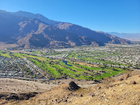
The earlier portion of the trail provides views to the north. The massive Bob Hope house is visible once you get a clear view to the east. After significant climbing, you reach a crest, and a junction with the Berns trail. A bit northeast here takes to you the peak. A huge pile of rocks marks the summit.

For my return, I took the Berns trail southwest, soon connecting with the Garstin trail, then eventually reconnecting with the Henderson trail, just before reaching the residential areas below. The Henderson trail runs up and down some as it stays in the volcanic hills rather than running along the wash bottom. About five miles for this loop.

The next morning, before driving home, I decided to explore this area from the other side. I took the Araby trail, which is another way up to Cahuilla Peak. Confusingly, however, you don't take Araby Road to this trailhead. Instead, you stay on 111B about 1/3 of a mile past Araby Road. Immediatey after crossing the bridge over Palm Creek Canyon, make a right. There'll be a green road sign saying Southridge/Rim (Drive), and also have a brown sign saying "Hiking Trail." Immediately after turning right, a small parking area, large enough for 12-15 vehicles, will be on your right.

From the parking area, another "Hiking Trail" sign will send you briefly up Southridge Road, before the trail shoots off, on the left side (if you're facing uphill) of the road.

This trail runs above a lot of mobile homes on your left, and larger permanent homes on your right. It's private property on either side, so stay on the trail and respect the privacy and property of trail neighbors.

This trail runs up the canyon on the opposite side from the Bob Hope house, before eventually placing you right south of the house. From this angle, a large water tank behind the home is obvious, as is a putting green with several sand traps on the west side of the house (not visible from west, due to foliage).

The Araby trail hits the Berns trail at the ridge, and the Berns trail heads west, to Cahuilla Peak. Perhaps slightly longer to the summit than via the Henderson, Shannon, and Berns trail, but shorter than the return via the Berns, Garstin and Henderson trails. Large portions of both trails are within the Santa Rosa and San Jacinto Mountains National Monument.

I suspect the trail is mainly used by locals, but plenty of tourists to Palm Springs are also there for the outdoor recreation. On the Sunday afternoon and Monday monrning that I hiked, there were usually other hikers or joggers within view, but the views were expansive, so it definitely didn't feel crowded. Good climb, but not very long, so not that strenuous, at least not when the weather is temperate.

Note that dogs are not permitted on the trail within the national monument boundaries.

Saturday, September 3, 2022

Redstone, Lake Mead NRA, NV, in May 2022

These are from the Redstone area of Lake Mead, just off of Northshore Drive Took these end of May/early June. Headed out here on Memorial Day weekend, and walked around in daylight, looking for possible foreground objects for some Milky Way shots. Came back the next weekend in the dark. The funny thing was the places I found in May in daylight, I could not find in June in the dark.

That's because I used my AllTrails to record my walking in May, but forgot to shut it off when I got back to my car, so I had a ridiculous recording that I ended up deleting I'll have to walk this area in daylight, again, and properly mark my shooting locations for nighttime location.

The general appearance of Redstone is similar to Bowl of Fire, except that, because it's so much more accessible and gets more visitation, you don't have many places with the fine and fragile sandstone structures in Redstone that you get in parts of Bowl of Fire.

The more I walked around, the more small windows and arches I found. Then, of course, I could walk to the other side of the arch and snap another shot.

I really wanted to try to snap this guy with the Milky Way, but couldn't find him, in the dark. Definitely something I'll be looking for, next time.

This is the arch you could see from near the parking area. I walked to and through this arch on a previous trip. This time, I also scoped it out from the other side, on a long loop walk around this section of Redstone. But, apparently, this shot didn't make the cut!

Further south and east from that arch were some interesting water-erosion features.
Wavy layers in the sandstone blocks.
Also, lots of "blueberries," like they found on Mars.
Finally, the night shot I took, when I came back. The Milky Way was barely rising, but I did like the effect. I was planning to get back here a few months later, with the Milky Way higher. Not successful, however. As has been the case for a while, lots of hikes remaining to be blogged.

Sunday, July 24, 2022

Lightning, Lake Mead NRA, NV, July 17, 2022

Not an actual hike. I took these last Saturday, July 17. Headed out to Lake Mead NRA, NV, with the intent of doing some astronomy. However, before reaching my intended destination (Redstone), it was obvious that the clouds weren't going to let me do much observing.

So I pulled off at Northshore Summit trailhead, from which I have hiked many times.

Lightning was frequent off to the west, over and beyond the Las Vegas Valley. Definite monsoonal storms, all over the southwest U.S. that night. So I set up my camera and shot numerous 10-30 second exposures, using a mixture of ISO and f-stop settings on my Nikon 85mm f/1.8 lens.

Most of those shots were then cropped, partly to make the lightning more prominent and partly to crop out the ridiculous number of jet trails crossing the frame.

This was my first semi-serious effort at catching lightning. I'm pleased with the results.

I was mainly heading out to track down Comet 2017 K2 Panstarrs on my own. Not able to do that. Will probably try again, though not sure when.

This one isn't getting very close to us, nor all that close to the sun, so it will only be marginally naked eye, at best.

Multiples hikes still to blog. Finally went through my dslr shots from lake June, from a trip into the White Mountains and eastern Sierra. Hope to get those up in the next week or so.

Saturday, June 25, 2022

Bishop Pass, Inyo National Forest, CA

Hiked July 5, 2021. As with my previous post, this was from nearly a year ago. The day after I hiked to Upper Lamarck Lake, in fact.

I did this hike the first time back in grad school. I can't recall the exact year, but I'm thiking the early 1990s. Obviously I was younger, and in better shape. But I built up my endurance some last spring, and did a number of pretty serious hikes by the time I got to July. With the warmup of the previous day, I was pretty confident about being able to do this hike ,again.

The trail starts from South Lake, one of several "lakes" (actually reservoirs) above Bishop. AllTrails gives the distance as about ten miles and 2,300 feet of elevation gain. It's definitely a tough one.

As with all of these Bishop lakes, there are numerous hiking options from each lake. No wilderness permit is required for a dayhike.

Despite being early July, there wasn't a lot of remaining snow on the mountains, but the streams linking each sequence of the lakes in the canyon were still running nicely.

With the many options, one decision point for me was at the Chocolate Lake/Bull Lake turnoffs. About halfway to Bishop Pass, I had the option of bailing on my full distance and looping back around a series of lakes at lower altitude. But I felt strong at this point and decided to continue.

The lakes I passed were as picturesque as I remembered Some wildflowers along the lakes and creeks, but actually not as much as I thought I might see for being so early in the season.

Still, lots of green grass in the small meadows near the lakes.

The waters were clear, and I could see many fish in the small creeks and lake waters. Looked like brook trout, with the distinctive white fin edges.

The long final climb to the pass was long and hard. No shade as you climb above treeline, either.

I took plenty of pictures, both with my dslr and my phone. Made it easy to compare to my maps later to match up lakes with names.

The actual panorama from Bishop Pass was less expansive than I recalled. Not entirely shocking, as, despite being at nearly 12,000 feet, it's a pass, so naturally the mountains on either side rise much higher.

Continued shooting like crazy, and resting up a bit, rehydrating, before heading back down. While at the pass, I could see several hikers on either side of the pass.

One of the amazing things I learned from one of the hikers is that some locals make a day out of running between North Lake and South Lake, via a 50+ mile, roughly 10,000 verticle feet gain trail that links the two trais. That would explain that I saw a few women run past me on the way up, but did not get passed by the on the way back down. Oh, they could have gone to a different lake, of course, but they may have been making this crazy run, instead.

On the decent, I came across several pockets of what I assume to be desert bighorn bones. I presume a small herd got caught in a snowslide or something. There were quite a lot of bones in a pretty small area.

Passed the same lakes, creeks, and meadows in reverse order, all the way to the part above South Lake. At some point, I passed a family with kids, making their way back to their car. They were picnicing just above the lake. To me, this was "almost back," and I was feeling pretty happy, having passed the point of "Having fun" and reached the "Man, I'm beat, and can't wait to get to my car." But they had taken a much shorter walk, and were trying to coax their kids back and didn't feel at all like they were "nearly back." Funny difference in perspective, there, based on where we had started and where we had been, that day.

Monday, June 20, 2022

North Lake to Upper Lamarck Lake, Inyo National Forest, CA

Hiked July 4, 2021. Rapidly approaching the one year anniversary of a couple of hikes I took in the eastern Sierra, last year. Figured I better post them, soon. I don't think all the photos in chronological order, but they'll still give you a pretty good idea of what I saw.

Although I grew up in southern California and used to hike annually in the Sierra Nevada, I spent quite a bit of time away from "home," working in other states. In particular, the time I spent living in along Utah's Wasatch Front and in southern Nevada really shifted my recreational focus to points up I-15, and away from California. Also, it used to be those Utah and Nevada trips were to "empty" places, so much easier to go to on the spur of the moment. By contrast, even back in the 1980s, going to Yosemite was a crapshoot. Just easier for planning purposes to go northeast, rather than north.

About three or four years ago it occurred to me that that I hadn't been hiking in the eastern Sierra for years, and I should really go back. Couldn't always follow through on my desire to return, due to recent fire closures, which would completely shut down California national forests for most of the summer. Nuts!

At the same time, visits to Utah have become harder to pull off on the spur of the moment, due to growing popularity of those parks. In recent years, for example, Zion has substantially outdrawn the much larger (by area) Yosemite, and there are a lot fewer campsites in tiny Zion than there are in Yosemite and the surrounding Sierra Nevada.

At any rate, I got it in my head that I wanted to repeat an eastern Sierra hike from about thirty (!) years ago (probably my next blog). But that one's a tough one, so I wanted to give myself a day to acclimatize to the altitude.

So my first hike after driving up from the lowlands was this shorter hike, out of North Lake. North Lake is one of three major jumping-off points at the head of Bishop Canyon: South Lake, Lake Sabrina, or North Lake. To get to North Lake, you drove up Bishop Canyon towards Lake Sabrina, then turned off on a mostly-dirt road just before getting to Sabrina.

It's a pretty exposed drive, but easily doable with a Prius, so not rough. Winds quickly up to near North Lake. But you can't actually park at the end, because that's a campground. I discovered on this trip that the campground didn't fill, even on Fourth of July weekend. But I already had my room down in Bishop. Just filed the information away for future reference.

I parked about 3/4 of a mile from the end, at a widespot in the road, where other cars were parked. On my walk along that road, I noticed it was lined with aspen, and also filed away for future reference that this might be a really nice fall hike. In fact, I did return here in the fall, and the colors were spectacular.

I planned this trip just by looking at USFS publications and what not. They had a flyer like this, but with information about hiking distances, but I can't find it, any more.

Lots of green meadows and wildflowers as I made my way past North Lake. Nice leopard lily, I think.

That one was right on that first climb after the campground. Many more varieties of flowers on this hike. This was early season, after all.

The approaches to each of the Lamarck Lakes passed by their outlets, with cascading water and more water-loving plants. Meanwhile, with the steep climb, there were amazing views of the surrounding mountains too.

I think I lost the trail just before reaching Upper Lamarck, or maybe I just didn't care, at that point. I just wanted to get a good view of the lake before I turned around. So I wound up on a rock outcropping, with the lake to my front and left. It was a nice view, but it was clearly not the actual trail.

This picture here was my turnaround point.

I think the next two shots were well-back, on the return, while the last few were below lower Lamarck Lake. I spent quite a lot of time on the way up trying to get shots of the flowers with a watery backdrop.

AllTrails gives a distance of two miles each way for this hike, and 1,600 feet of altitude gain, but I'm pretty sure that assumes you start at the actual trailhead, which you can't do, unless you're camping in the North Lake campground. Add 1 to 2 miles roundtrip, depending on where you park, and a bit more altitude, also depending on where you park. It's a pretty good distance for a just-arrived hike, as it's at significant altitude. North Lake is at about 9,100 feet, and you go up, from there.

It was a good start to the trip. Just right for the time had. In fact, it was getting pretty dark by the time I got back to my car.

Very dark by the time I made the drive down. Fourth of July fireworks was going off down in Bishop.
No permit required for dayhikes. Obviously, hiking too much after dark is not necessarily a good idea, due to the presence of human-acclimatized bears. So, if you are hiking much after dark, try not to smell like food.