 Hiked Monday, March 19. I enjoyed a brisk but sunny afternoon walking above Schabarum Park. From the Pomona Freeway (CA-60), exit at Azusa Avenue and head south. As you approach Colima Road (less than a mile from the freeway), move over into the second lane from the left. There are two left-turn lanes from Azusa on to Colima, and you want to be in the outermost one (the second from the left) because you need to make a right turn into Schabarum Park almost as soon as you complete your left turn.
 On weekends, there's a $6 charge to enter the park. It's free on weekdays, so of course I made my trip on a weekday. ;D
After passing the unmanned entrance kiosk, I followed the "main" road straight, then to the left. It's 15 mph, and, of course, there are lots of people and cars in the area, even when the park is not very crowded. Drive carefully.
 After what seems like a mile, the road deadends in a parking area. A restroom (locked when I've been there, but probably unlocked on weekends) with a large number "8" is at the end of the road, as is a small wooden trailhead sign. Head left on the trail to leave the park and head for the hills.
 A general map of the Habitat Authority trails, including for the area around Schabarum Park is located here. The area to the south of Schabarum Park is covered in the Powder Canyon map, here.
I'm pretty sure the end of the road is just north of the trails crossing each other, near the south end of Schabarum Park.
 As you begin your walk on the trail, the backyards of homes are on your right. After maybe 1/4 mile, there's a fork in the trail, which I believe to be the trail crossing on the map. I took the right one, although both would eventually take you the same way (you can make a loop out of this trail if you're so inclined). My impression is that the right fork takes you up quicker.
In sections, this trail is quite steep. There are also some erosion ruts along the way. I passed some monkey flower, and a couple of buzzing hummingbirds. They stopped visiting the flowers when they saw me, and one sat impatiently in a tree some distance away, waiting for me to leave. In the pictures, he looks fatter than I thought he was, but is definitely more colorful than the typical green hummingbirds I've seen in the past.
 As you climb up into the hills, the homes of Hacienda Heights and La Puente are below you. Beyond that is the venerable Puente Hills Mall and the Pomona Freeway. On the other side of the freeway are the white roofs of City of Industry warehouses and factories. The large rectangular building on the hill a few miles out and slightly to your right is the Industry Hills golf course, hotel and conference center. The hill on the other side of Azusa Avenue is West Covina, and the reclaimed hills of the BKK landfill.
 Beyond that are the San Gabriel Mountains. On a clear day, they can seem right next door. On a hazy day, they may be invisible.
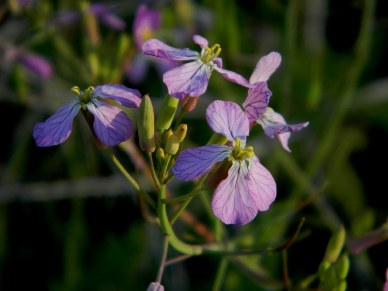 This trail eventually makes its way up to the Purple Sage Trail. Just before you make the final looping ascent to the hill top where you'd hit the Purple Sage Trail, there's a broad, sweeping hillside that you pass along. In season (which would be now, and for the next few months, depending on the weather), it's covered in wild radish. They're a mixture of white and purple, and can look very pretty. Apparently, these were introduced into southern California by the Spanish, right about when they brought in the wild mustard and te Spanish broom that are so common in our foothills. Native wildflowers have been largely displaced by these relative newcomers.
 There was a nice soft afternoon sunlight coming in low over the hill top, and I went bonkers, shooting lots of pictures of the wild radish. I've got about seven of them here, but there are dozens more elsewhere.
 Continuing along the trail, you loop towards the west, then back the east, atop the hilltop. Views improve as you climb. You'll also soon reach the Purple Sage trail. If you go left there, you could loop back around towards Powder Canyon, and return that way.
 Instead, I went left, along the rest of the Purple Sage trail. I shot some pictures of thistle, lupine, vetch, and wild mustard as I did. I also took plenty of shots of a pair of red tailed hawks that rode thermals in the area, but those came out somewhat blurry, as usual.
 This trail passes by numerous radio towers and eventualy reaches a paved road. Crossing that road would send you west, towards Hacienda Blvd. However, I turned around there and made a large clockwise loop, back on the Skyline trail and towards Schabarum Park.
Total mileage was probably around five miles for the day.


Hey Skyhiker, hope my horrible joke wasn't misinterpreted. A friend of mine didn't get it at first so I hope I didn't offend.
ReplyDeleteWell, I didn't quite get it, but I think I understood the gist, and, no, I was not offended. No worries!
ReplyDelete