Monday, September 16, 2019

Lost Horse Valley Trail, Joshua Tree National Park, August 24, 2019

After finishing my relatively early morning hike at Split Rock I got back in my car, and contemplated what to do, next. It still didn't seem that warm and it was still pretty early. So I wanted to get a bit more hiking in, before retreating to my motel room to wait for evening.
I continued west on Park Blvd, staying on Park Blvd when I passed the road to Keyes View. I stopped in a parking lot, about 4/10ths of a mile past that turn, to, again, contemplate my next action. Pulled into a small parking lot. There was an informational sign, so I stopped to read about Minverva Hoyt.
After reading that, I noticed that there was a trailhead sign. I didn't look at it too carefully, but I saw that it was supposed to be 1.5 miles long, and it would lead to petroglyphs and Hidden Valley. Of course, I'd been to Hidden Valley before, and it was obvious that this would be a mostly flat trail. One and a half miles each way seemed very doable, and I could turn around any time I wanted. But petroglyphs! So I put my day pack back on and headed down the trail.
In retrospect, I think this trail starts off along what is shown on my Trails Illustrated map as "Old Lost Horse Road," but which was signed at the trailhead as "Lost Horse Valley Trail."

After starting off in a northwestern direction, it makes a 90 degree right turn after just over 3/4 of a mile. Then it heads right to the end of the parking area a Hidden Valley.
I hadn't seen any indication of petroglyphs along the way, although I did see plenty of Joshua Tree. So I looked more carefully at the trailhead sign on this side of the trail, and still didn't really figure out where the petroglyphs were. I did recall seeing what looked like a spur trail towards the rocks, a half mile or so back. So I quickly walked back to that spur, headed towards the rocks, and wandered some along the outer edge of Hidden Valley.
I eventually came across "Zombie Woof," which didn't look like much, and weren't the petroglyphs that were promised. The rocks up there on Zombie Woof did look stained, however, and I suppose geologists and anthropologist could look at these faint and not-obviously shaped to represent anything as being unnatural, and, therefore, of ancient native American origin.
I also saw desert pantina-covered rocks all around the edge of Hidden Valley, but could not determine if any of the marks were anything other than random breaks in the pantina.

I eventually made my way along those rocks, all the way back to the Hidden Valley trailhead.

I took another, closer look at the trailhead sign, followed the path more carefully, and examined both small outcroppings on the left side of the trail (as you leave from Hidden Valley). Saw the desert pantina on some of the rocks. And, on the second set of rocks, saw what appeared to be the actual petroglyphs I was promised. Definitely not distinct and obvious from a distance, but there they were.
Few shapes were well-defined, so this wasn't the most dramatic example of petroglyphs I had seen. Yet, for the Mojave, they were pretty clear.

One of these days, I'll have to visit a few other sites in the Mojave Preserve, to see if I can find what appear to be more obvious signs of ancient communication.
As I approached the rocks, by the way, a large hawk first approached from the other side, then veered away, when he saw me.

A bit after that, I saw this fairly-large rabbit, just sitting there. I didn't want to spoke him, as that might have drawn the raptors attention. So I snapped a few pictures, but kept my distance. And we both got to walk away from this experience, alive.

Thursday, September 12, 2019

Split Rock Loop, Joshua Tree National Park, CA -- August 24, 2019

On Friday, August 23, I drove over to Joshua Tree to take some nightscapes around Arch Rock. That was a late night. But the next morning, I wanted to do at least a little hiking before heading back into town.
I wanted to cover some new land, and I was pretty sure I hadn't hiked from Split Rock, before. The trailhead is off of Park Blvd. From the North Entrance (south of Twentynine Palms), head south, then stay right where Pinto Basin Road splits off to the left, and heads towards Cottonwood Springs and I-10. Another 2.6 miles, and there's a turnoff to the right, a dirt road that ends at Split Rock trailhead.
From the parking area, the loop heads both west and north. Since it's a loop, you can start off heading either way, and you'll return via the other trailhead.

For no particular reason I started off to the west. A rock outcropping with a visible crack is presumably the "split rock" for which the area is named.
It's a two mile loop. There's a spur trail from the southern end of the loop that heads towards Skull Rock. There's also supposed to be a trail that heads off on several spurs to the north and northwest, but I did not see that junction.
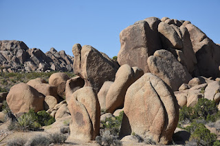
The trail takes you past numerous interesting rock outcroppings, some with balaned rocks. Very few Joshua tree. And, because I was there in the dead of summer, not a lot of flowers in bloom.
I saw a few jackrabbits on this trail, and lots of lizards. Besides the rocks, that's about it.
I can imagine some may choose to climb some of the rocks around the area. Many of those might require walking across delicate soils, however. I can also imagine that some of these areas might make good foregrounds for Milky Way nightscapes.
With a moderately early start, I finished with the temperatures still seemingly comfortable. My car thermometer said it was in the low 80s.
Despite these low temperatures, I was somewhat surprised by how few people I saw out in the park, even in the morning. A pair of hikers returned to their car as I headed out, and I think I only passed one other couple while on the loop. Maybe three other cars in the lot, when I got back.
Nice little hike. Since it still wasn't very hot, I wanted to take another short hike. Although this wasn't my original plan, I ended up hiking Lost Horse Valley trail, which was not even on my Trails Illustrated Joshua National Park map. More on this, next time.

Saturday, September 7, 2019

Labor Day Weekend 2019: Zion Canyon and Pioneer Park, Utah

Took advantage of the three day weekend to sneak a little time in Zion. Slightly later start than desired, and I knew I was going to catch some traffic driving through the Arizona Strip.

My plan for the week was to leave reasonably early on Saturday morning. It's about six hours of driving to St. George, but with traffic and leg-stretching breaks, you need to allow about seven hours. Another hour to Zion.
The tricky part was not to get there too early, because all of the parking in the park would certainly be filled, possibly even before I got out of Los Angeles County! In fact, the plan was basically to get there after most people had left Zion, so I could find somewhere for me to park.

Checked in to a Super 8 on St. George Blvd. It was a bit less than sixty dollars, with tax, and about twenty dollars less than something similar in Hurricane (20 minutes or so closer). Within the same family of hotels, there's a La Quinta in Springdale. Unfortunately, for me, I learned that a free night there would cost 30,000 points, instead of the 15,000 points (or less) for most Super 8 or Days Inn-type places, even if the nightly rate in some of those is higher than the La Quita in Springdale.

I mention all of this in relation to the logistics of trying to visit Zion. If you can't get there early enough, you can't find parking in the park, at least not near Zion Canyon. And parking in Springdale cost as high as $20 a day, in addition to the regular Zion National Park entry fee, and even that can fill pretty quickly. My assumption was that on the Labor Day weekend, this was especially likely to be true.

So I spent some time in my motel room, eating a late lunch/early dinner, and contemplating my options, given the remaining sunlight. Decided I'd just settle for the Pa'rus trail. The main goal, after all, was just to get some Milky Way shots, with the Watchman as the foreground.
Fortuitously, a car backed out of a spot at Canyon Junction just as I got there. If there were no spots there, I was just going to go back up to the Human History Museum, a mile down the Virgin River. But with a spot found, I was set, for the night.

Also turned out there was a portapotty right at the shuttle stop for Canyon, so, again, set for the night. :D
Astronomical twilight did not end until about 9pm, so I had plenty of time to walk the mile and a half or so from Canyon to South Campground, and back. Snapped a few shots. I also saw evidence of construction. I'm not sure if there's planning on adding vault toilets or just informational kiosk/rest benches along the way, but construction is under way.

I think all of the shots I posted ended from Zion ended up being taken just north of where the trail from the Human History museum intersects with Pa'rus. I later took a number of shots from the bridge at Canyon Junction, but liked these, better. Used both my Nikon 35mm and 20mm f/1.8 lenses.
The next morning, I visited Pioneer Park. Not even a mile drive to get there from my motel room.

This is a small park, traced around a lot of red rock sandstone. There's a small arch atop one of those rocks. The regular trail to get there is up the very well-defined, decomposed granite trail below and to the right from the second parking area. That comes up from behind, and is maybe a quarter mile in length. But I think most people just walk right up the sandstone to get there.
I didn't measure the arch in size. I can say that a person could crawl through it, but not walk through it. I did neither, of course.

As it's sandstone, it's soft, especially when wet. Many names and other things carved on the sandstone, including on the arch. I didn't do that, either, of course.
That was on Sunday morning. Then I drove down to Las Vegas, wanting to get through the Virgin River Gorge before traffic started building.

It was something ridiculous, like 110 degrees, in Las Vegas. Didn't do any hiking there.

There are a number of other places I'd like to visit around St. George, and in the Virgin River Gorge. But I think I'll wait until late fall or early winter, after it's cooled down a good deal, before visiting those other places.