Wednesday, May 29, 2024

Griffith Observatory to Mount Lee (Hollywood Sign)

Hiked May 24, 2024. I've hiked to the Hollywood Sign a number of times, but can't offhand recall the last time. On Friday, I was at the Observatory with about three to four hours to spare, and was curious if that was enough time to hike from the Observatory to the Hollywood Sign and back. The answer was, yes, three hours is long enough, if you know the shortest way and walk quickly. I call this the "ridge route," because you run overlooking a pretty good drop-off to your south for a bit. Unfortunately, the directions are confusing enough that I won't try to describe all the turns, but the general plan would be to stay high and resist losing altitude. But don't go up any intervening peaks -- keep the taller peaks to your right on the way out.

On this trailmap, you'd start from the Observatory, walking north, to the Charlie Turner trailhead, take the trail over Vermont, then take the thin, steep trail on your right (not the rutted use trail along the pipe) to meet up with the Mount Hollywood trail, south of Mount Hollywood. There is one trail junction along this route, where heading straight would take you down to Vermont and the "Bird Sanctuary, while left takes you up towards Mount Hollywood.

Once you rejoin the big dirt fire road, turn right and walk along the eastern side of Mount Hollywood, then continue to the "North Trail," towards Taco Peak.

[If you go right, along the west side of Mount Hollywood, it's my suspicion that it's slightly longer and with some wasted climbing, but the difference is not great.]

As you near Taco Peak, take the narrow trail along the big pipe up and around the north side of the peak. Once to the north of the peak, it's a wide dirt road that'll bend back around and take you towards Mount Bell. I typically follow the dirt road down and around the south end of Mount Bell, following that dirt road until it reaches the paved (but closed to public vehicles) Mount Hollywood Drive, then picking up as it climbs a bit up to the pass between Mount Chapel and Taco Peak. There, a narrow trail heads long the "ridge," towards the summit of Mount Chapel. Veer left before the steepest ascent begins and stay to the south of the peak. Follow that thin trail, with many ups and downs, as it runs south of Mount Chapel's summit. There may be quite a lot of brush, with lots of bees visiting thef lowers of that brush. Long sleeves and long pants could be helpful.

Just before you reach paved Mount Lee Drive, a clear but thin trail drops down and to the right, while the possibly clearer use trail continues along that last bit of ridge, before it reaches a dead end. If you come to the deadend, backtrack the few yards to the spur that dropped to the northwest. It hits Mount Lee Drive within 50 yards or so. Once on Mount Lee Road, walk the pavement up (right, intially) to the top of Mount Lee. You'll pass to the north of Mount Lee first, with Forest Lawn and Burbank to your right, along a long incline. When you make the hairpin turn, you'll see the back of the sign.

Had you continued on the dirt path straight ahead instead of turning with the road, you'd go to Cahuenga Peak, then on to Burbank Peak.

Continue past the sign a few yards, and trail takes you to an overlook, on your left. You can see and photograph the entire sign's back more easily from up there.

It's now late spring. Still some flowers in bloom, though not too many really thick blooms. Rattlesnakes are also active, though I didn't see any. The narrow "Ridge Route" offers some rattlesnake potential, btw. Sticking to the wider dirt roads would be safer from a rattlesnake perspective, though somewhat longer.

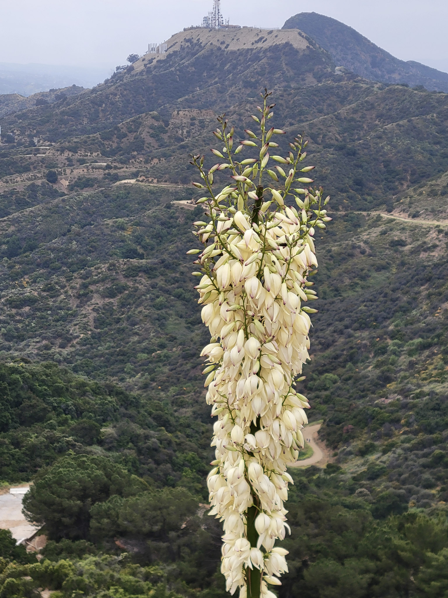
In terms of what flowers you're looking at in this post, in order, it's bush sunflower, bush sunflower, bull thistle, Indian pink, farewell to spring, California buckwheat, blue dicks, wild mustard, sticky monkey flower, golden yarrow, chaparral yucca, pearly everlasting, farewell to spring, phacelia, and morning glory.

As noted at the top of this post, I made the roundtrip in under three hours (about 2:45). This was with a slight wrong turn around Taco Peak on my return, which added about 8 minutes, I would guess. I've done this hike often, but not that recently, so I wasn't always sure I was on the right path, but that's the only wrong turn I made. Also, I'm a pretty fast walker by nature.

My Alltrails showed the total distance I covered as 6.12 miles, a gross altitude gain of 1158, and 2:11 of moving time (meaning, ignoring my stops for pictures or to sip some water), which is roughly a three mile an hour pace, which sounds about right. So, although it was less than three hours from the Observatory to the Hollywood Sign and back for me, if I wanted to stick to the wider dirt roads and rely on line of sight to choose my path because I was less sure of the proper route, I would definitely allow four hours roundtrip.

Just adding the Mount Hollywood Trail part in (rather than cutting up the steep designated trail that starts right after the Vermont Tunnel) adds at least two miles, roundtrip. Dropping down to the Mulholland Trail instead of the "ridge route" probably adds a similar distance. So then you'd be talking about 9-10 miles rather than 6 miles, which would be a non-trivial increase in length. The longer way also adds more gross altitude to be gained and loss.

Of course, if you just want to get to the Hollywood Sign, there are shorter trails to get there. But if you park anywhere directly south of the area between Burbank Peak and Mount Lee, be careful. The roads are narrow and winding, and the closest paved roads are highly restrictive in terms of parking.

This way works for me because I have convenient parking up near the Observatory. If I parked down at the Greek, that would add another mile or so roundtrip. Alternatively, if I took the free DASH bus up to the Observatory, the distance would be the same as parking up there.

If you're taking public transit to the Observatory, the Observatory LA DASH bus is free (as are all of the local circulator DASH buses), and runs between the Sunset and Vermont subway station and the Observatory, with several stops in between. This subway route used to be called the Red Line, but now is called the B-line, because it was the second transit line built, after the "Blue" or A-line, that runs between 7th and Wilshire ("Metro Center") and Long Beach.

If driving a car, from DTLA, you'd either take the Hollywood Freeway (US-101) north and exit at Vermont, heading straight north from there up to the Observatory, or you'd take the Golden State Freeway (I-5) north and exit and Los Feliz. Take Los Feliz west, and turn right (north) at either Hillhurst or Vermont. The two streets merge a bit up the hill, and continue on to the Observatory.

From the north, if on I-5, you'd still get off at Los Feliz and head west, same as above.

From the 101, you'd probably exit at Hollywood or Sunset, head east to Western, then north, until you merge with Los Feliz. Then Los Feliz east, to Vermont.

If you just want to get to the front of the Hollywood Sign or to Burbank Peak, you'd be able to get a lot closer by using one of the trailheads closer to Lake Hollywood Park. To get there, I'd exit the Hollywood Freeway from Cahuenga, and take that to Barnham, then head "east," then turn "east," again, on Lake Hollywood Drive. [The streets don't run in the cardinal directions around here. There's a traffic light at Lake Hollywood Drive that just says "Lake Hollywood," and there's only one way you can turn, there.]

Lake Hollywood Drive is pretty narrow in places, with either limited or no parking rules along several sections. Check signage before you park, including any signs you may pass with an arrow (indicating parking rules for extended segments of road).

There may be parking near the end of Innsdale Drive, parts of Tahoe Drive, and the part of Canyon Lake Drive adjacent to Lake Hollywood Park, although I haven't hiked around Lake Hollywood Reservoir in a few years, so I'm not sure if accessibility has changed. I do know that the exit off the 101 for Barnham was removed, which makes the slightly more complicated route to this area necessary. They have also changed street parking rules a few times in this general area, because it can get congested.

It should go without saying, but if you do try to hike from the area south of the Hollywood Sign, don't block any driveways and follow the rules. The bigger pain in the butt you make things up there, the more likely additional restrictions and stricter enforcement will follow.

Tuesday, May 14, 2024

No aurora for me!

Late Friday night (May 10, 2024), my facebook feed blew up with various people reporting aurora borealis (Northern Light) sightings as far south as Arizona and southern California. It was overcast at home that night, and so I just looked out a north-facing window and saw nothing. Had I been less tired, maybe I would have driven up into the Angeles National Forest, but I was tired, and still a little skeptical. But the postings continued into the next day, and the possibility of more sightings the next day had me interested.

The next night, I was already planning to head to Joshua Tree National Park, to do some regular night sky viewing and maybe some astrophotography. Meanwhile, earlier on Friday, I discovered that Sky's the Limit was planning to do a dark sky observing event, so I contacted them and got approval to volunteer for that. Sky's the Limit is located directly on the boundary of Joshua Tree National Park, north of Twentynine Palms.

After the outreach event wrapped up (a success, of course!), I got my car packed up (around 11pm) and I headed into the park, trying to put some distance between me and Twentynight Palms. Folks, it was a complete zoo in the park on Saturday, which I suppose I should have expected. There were literal five minute long periods when a continuous line of cars would make it impossible to pull back into traffic. Cars were parked along the road and continually circling through parking areas. No way you could get dark adapted if you didn't walk some distance away from the roads and parking lots.

Aurora-wise, it was a washout. Even if there were faint lights to be seen, it would have been hard to see. The shots I posted were what I got, which was a lot of car head and tail lights, and no aurora. Only funny things photographed were artifacts from car lights, reflecting within my camera lens.

Reports from the Interweb confirmed that the aurora on Saturday night were a lot weaker than the ones on Friday night, and no significant sightings were posted for our vicinity.

On an unrelated note, a couple of other space-themed photographs from the past week. SpaceX launched another set of satellits out of Vandenburg, which was visible all over the southwest US. This was on May 9. Also on May 9, I photographed the two-day old crescent moon. I photographed the one-day old moon, the night before. That was the narrowest crescent I ever saw.

Friday, May 10, 2024

Ice Age Fossils State Park, North Las Vegas, NV, Hiked May 5, 2024

I had read about Ice Age Fossils State Park opening just a few months ago. On reading more, I learned there's an actual visitor center at this park, unlike the national monument that virtually surrounds this park (Tule Springs Fossil Beds National Monument). Because I figured it pretty likely that I wouldn't actually see (or recognize, even if I did see) any actual fossils in situ, I wanted to be taught the significance of this place while also being on site, to hopefully learn a little more effectively that just by reading.

The visitor center is pretty small, and likely wouldn't take a visitor more than 20-30 minutes to read each exhibit and description. But it was indoors (climate controlled) and flush toilets and drinking water were on site, and provided good insight into how prehistory can be reconstructed.

None of this would be true of the national monument mentioned, above.

[I hiked a part of Tule Springs Fossil Beds National Monument a few years ago, but apparently didn't blog it. It consists of a boundary, and two trails, both of which are considered "temporary" trails, because they don't actually take you near any likely fossil finds. They only exist to count visits and provide visitors something to do in the area. There is also extremely limited on-site interpretation. It's basically left up to the visitor to download the information on their website as you walk around]

In my case, I walked around, first, then hit the visitor center, to sort of reiterate what I saw on site. But the signage on the trail was informative. I could see the spot where a large mastadon tusk was found in the 1960s, then reburied, then rediscovered in the 21st Century, and where a tiny Dire Wolf knuckle was found. [The knuckle was the only solid evidence that Dire Wolves once lived in southern Nevada. The mastadon tusk was found partially wrapped in a 1960s Las Vegas area newspaper.]

Of course, for me, not being bound by the rules of science, I can make up stories about time travellers buring mid-20th Century newspapers into the ground, thousands of years ago, and mobile, trading indigenous people taking bones from the La Brea Tar Pits and burying them in southern Nevada. [No, I'm not serious, but, yes, enjoying thinking up ascientific alternative explanations].

There are three designated trails in Ice Age Fossils State Park. The shortest is the Megafauna trail, a 3/10 of a mile paved trail around metal "sculptures" of dire wolves, North American lion, mastadon, and other large mammals that lived here during previous ice age periods. I didn't use a tape measure, mind you, but some sculptures did not seem proportional to how large they should be. Those old bison were huge!

The other two trails form overlapping loops around areas that were excavated in the early 1960s, and areas where "natural" erosion of the Las Vegas Wash exposed layers of deposits. Walking all sections of the three trails, and the connectors, totaled a little over 4.5 miles for the day. That's longer than it had to be because I needed to pee, so walked back to the visitor center after finishing the Big Dig trail, then headed back out to cover the parts of the Las Vegas Wash trail that I didn't cover on the way back, the first time.

The significance of this area (both the state park and the national monument) is that springs once rose here. Rains that falls on the Las Vegas Mountains travels underground, until it reaches an imperious layer, where it seeps back up to the surface. When it rained more, the springs were hearty, and the area was marshy, with ponds and lots of plant and wildlife, and animals that died around here could be buried by silt and fossilized in large numbers. Hence, the density of fossils found here.

Today, the springs in this particular area are gone, but the wash remains. The wash is generally dry, but during infrequent rains, can briefly fill and rage from here down towards Lake Mead. When it does that, it erodes down in the wash, exposing some of those ancient fossils.

Back in the early 1960s, somebody got the idea of bringing in heavy machinery to dig large swaths of silt and clay to be searched for fossils and evidence of prehistoric human habitation. This was called, "The Big Dig." Obviously, that's a pretty destructive way of excavating, and, I would think, has great potential for mixing finds in various depths (hence, various ages) together. It's not something that would be done, today.

This being a desert, and the silt and clay (caliche) are hard, and slow to erode, so those trenches from over 60 years ago are still very obvious. It's just piles of dirt and cliffs of sediments, but the potential for future research in unexcavated sections and along eroding walls obviously remains, in both the state park and the national monument. That makes interpretive signs and museum exhibits so important for lay persons such as myself.