Tuesday, September 29, 2015

Hike 2015.067 -- Sunset Ridge to Echo Mountain

Hiked Saturday, August 29. 5 miles. That would be a month ago. Still far behind in my blogging.

Don't remember the conditions of this hike, other than that there were plenty of flowers blooming.
Nothing like Antelope Valley California Poppy Reserve State Natural Area in the spring time, of course. Nor, even like these same trails in the spring time. But, like many desert and semi-desert areas, there's a second season of growth, as you approach the fall. Also, some significant rainfall in July helped to prime things.

This was just a quick little dash into the foothills. While I usually park down near the Millard Canyon campground, this time, because the goal was Echo Mountain and I was somewhat limited on time, I decided to park up on the ridge.
To get to this trailhead, you go north on Chaney Trail, off of Loma Alta Drive. To get to Loma Alta Drive, you'd likely take the Foothill Freeway (I-210) to Lake or Fair Oaks. Either way, go north, then turn left when you reach Loma Alta (it's a good, long drive). In the case of Lake, you'll have no choice to turn left, since lake terminates at Loma Alta.
A few blocks after Fair Oaks (and several stop signs, as I recall), look for a flashing yellow light, hanging above the street. That's Chaney Trail. Turn right, there.
You're now on a narrow, two-lane road, that soon gets narrower and winding. When you reach the crest and start heading down, there's a small parking area to your right (and left). Note the no parking areas and the requirement to keep access to the gate open.
From here, you're far enough away from the camp-ground and picnic area that no Adventure Pass is required (the Adventure Pass requirement down in Millard Canyon is one of the reasons I often drive down there to park--the fee requirement means there's pretty much always parking down there, even as the cars are lining the corner of Lake and Loma Alta with hikers heading up to Echo Mountain.

Once parked at the crest, walk around the gate. First on your left will be a trail that heads down, to Millard Canyon. Skip that one. Another 1/4 or so further, another trail is on your left. This is the more scenic way to Cape of Good Hope.
You could also just stay on the pavement, but that's not very scenic. The pavement, by the way, is also known (at least on google) as Mount Lowe Road. It's the rail bed that the tracks used to follow on their way up to Mount Lowe.
Meanwhile, if you're on the trail rather than the pavement, do keep an eye out for mountain bikers. They can move fast. Some hang cow bells on their bike, so you can hear them coming, but some don't, and some move so fast that you have very little warning before they're on you.
The dirt trail rejoins the pavement in about two miles. You're once again on the rail bed. Head up hill a very short distance, and look for the trail, on your right, that follows a different old rail way, over to Echo Mountain. Evidence of bridges and rail bed will be visible all the way to Echo Mountain, just about a mile away.

Overall, this is quite similar in distance, and has the same end point as the Sam Merrill up to Echo Mountain. But this way is a whole lot less crowded, though with the trade off of more mountain bikes.

I took a number of hikes from Millard Campground in August and September, at least three of which I have yet to blog. Much work to do, yet.

Saturday, September 26, 2015

Hike 2015.071 -- Placerita Canyon State Park, Heritage Trail, Manzanita Mountain Trail, and Botany Trail

Hiked Saturday, September 26. This is my third trip here on one of these "County Fitness Challenge" trips. About 8 times a year (skipping the winter months), the County Department of Public Health sponsors these events at one of a number of different county parks.

The goal is to increase the amount of activity engaged in by its employees, to improve their health and reduce health care costs. This means, for the events at the start of flu season, there are free flu vaccines. They also have various drawings (prizes contributed by the various health care organizations that provide health care to the County employees).

Well, I'm a big fan of "free," and, obviously, I love hiking. So when these event includes hiking, I'm almost always there. So this is the third time I've come to Placerita Canyon for one of these events. I've also visited numerous times on my own.

The Heritage trail is a short 1/4 mile or so each way, and takes you past a small cabin, and ends at the park boundary, just after "The Oak of the Golden Dream." It is said (but also contested) that this is the oak, beneath which gold was first discovered in California. There's a wooden fence around the oak here, plus some historical markers.

Meanwhile, the adjacent property owner, the Disney Corporation, claims there's another oak, on their property, that's the REAL Oak of the Golden Dream. Pretty impossible to prove, either way.

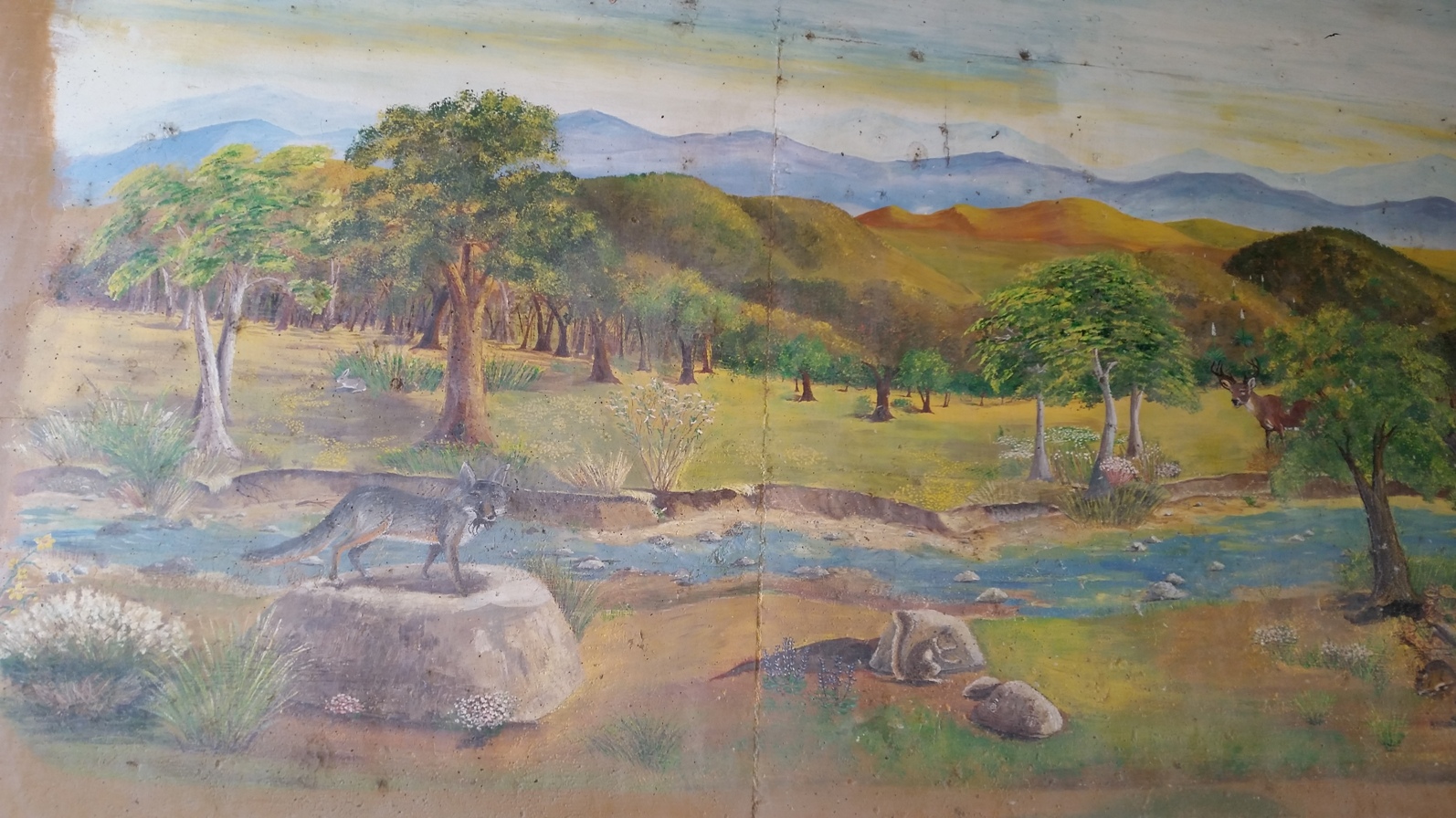
On the way to the Oak, the trail goes under Placerita Canyon Road. Under that tunnel are various murals that represent some of the historical changes that have occurred out here.

Next up for me was a walk up the Manzanita Mountain Trail. This one is supposed to be about 1.6 miles roundtrip. From the main trailhead, go straight, on the Hillside Trail. After 1/10th of a mile, there's a sign to make a sharp left turn, on to the Manzanita Mountain Trail. It's supposed to be .7 miles from here to the mountain top. I have to say it seemed a bit longer than that on the way up, but that's probably because it's REALLY steep in parts.

You'll know you've reached Manzanita Mountain when the trail takes you right by a MASSIVE manzanita bush.

I don't think the mountain top is visible from the trailhead, as an intervening hilltop intercedes.

I then rushed back down, not wanting to miss the drawing. Didn't have to worry, as they did re-call the names at the second drawing, and, besides, I didn't win anything!

Following the drawing, I joined a short nature hike. But, after a few minutes of that, I eventually left on my own. It's odd the things that will bother me (or, I should say, I can be bothered by odd things?). In this case, the way the ranger (presumably--she kept talking about having a badge, but that may have been more for effect than for veracity) pronounced words like "symbiotic" (which she pronounced "symbionic") and "chaparral" (which she pronounced, "shapa-rel"), and the mis-identification of a small purple flower, that she called a cliff aster, which clearly wasn't. They were aster, but not cliff aster.

All small things that wouldn't normally bother me, and I know I often say something other than what I'm thinking (meaning I know the right word, place, number, or what ever, but my mouth says something else), but, for this and other reasons unrelated to the ranger/docent (the heat, the size of the group, the speed we were covering ground), the whole thing just didn't seem conducive to learning, so I walked off on my own.

Walked the rest of the trail (given as .325 miles each way, but I don't know if they mean the loop is that long, or it's that far out and that far back, but I would suspect the former, because it seemed like well over 1/4 mile just to get to the turnaround point). Snapped a few shots.

Then got back in time for the second drawing. Didn't win anything there, nor had I won anything on the previous drawing. Boo!

At this point, I decided to go home, because BYU was playing at Michigan, and this game was on ABC. Thought it might be a fun game to watch. Alas, once in the car, I learned Michigan was up, 31-0. Well, heck! If I knew it was going to be a blowout, I'd have stuck around for another short walk or two, then waited for the third drawing.

Anyway, between my three short walks, my several walks from my car to the park headquarters and back, and the walks through the visitor center and between the trails, I'm sure I made my three miles minimum.

Placerita Canyon State Park is located off of CA-14. From the Los Angeles Basin, take I-5 north to CA-14. Placerita Canyon Road is only about 3 1/4 miles after getting on CA-14.

After exiting, turn right at the bottom of the ramp. This is Placerita Canyon Road. One and a half miles east on Placerita Canyon Road brings you to Placerita Canyon State Park.

Well, it brings you to the "main" entrance for Placerita Canyon State Park. I guess there's another entrance about 1 1/2 miles further, at the Walker Ranch. I've never actually driven up to there, though clearly some people do. From the main entrance, it's a two mile walk on the Placerita Canyon trail to get to near the Walker Ranch, where the trail to the waterfall shoots off to the south.

There is no entry fee for this park. Dogs are permitted on a leash.

Nice park to visit, though it can get hot in the summer. Better in the spring or later in the fall.

Monday, September 21, 2015

Hike 2015.024 -- Little Santa Anita Canyon to First Water


Hiked Thursday, April 9. 3 miles. Haven't had time to edit pictures for any of my other hikes. This one, I apparently edited some time ago, but never did the write-up. Well, now this is over five months after the fact, so I can't very well remember much about this hike. I do note by looking at the pictures that the water was very dry. Yes, it's a drought. But it's been an odd drought. If you were to just look at the rainfall totals since this hike (say, from May to September 2015), you'd see we're actually pretty far above average for the past five months. The two inches plus we got last week was the wettest September on record for Los Angeles
But, because it had been so dry the previous years, and also below average into April, Little Santa Anita Canyon had gotten very dry by the time I took this hike.
And, since this was still pretty early in the year, even with the below average rainfall, First Water was still pretty green.
Can't remember anything else specifically about this hike. It's one I've done many times before, even long before hiking became my semi-obsession. This was one of the earlier trails I learned of, and the first way I walked up to the top of Mount Wilson. I also have a fond memory of taking one of my aging dogs on a hike to First Water. He was well into double-digits by then, and maybe a little senile. But he still loved the memory of going on rides (which he hadn't done in years). He hoped into the car when he saw the leash, and excited ran back and forth on the drive up. Then he wound up sitting on my lap. Of course, this was before airbags, and I'm sure this wasn't ideal from a safety standpoint. But he was so excited to be "going for a ride," I could not force him to sit on his own.
He was also an excited hiker, and we walked quickly up the hill. But the plan was for this short, three-mile trip, because, hey, old dog, remember?

Once at first water, I explored a little downstream, and we both slid down a short chute. Fortunately, I had little trouble making my way back up, and I was able to push my dog up ahead of me.

We made it back fine, and got back in the car, for the drive home. My poor old dog was beat. He curled up and took a nap on the floor in front of the passenger-side seat.
The trail up Little Santa Anita Canyon starts in Sierra Madre. From the Foothill Freeway (I-210), exit at Baldwin Avenue and head north. Six blocks north of Sierra Madre Blvd, make a right at Mira Monte Avenue. The Mount Wilson Trail starts up the short, paved road that says, "Mount Wilson Trail," just west of Mount Wilson Trail Park. There is limited parking on the west side of the Mount Wilson Trail road, right at the bottom. Otherwise, park on Mira Monte. Walk up the paved road, then turn left, off the pavement, when you reach a sign indicating the trail. It's about seven miles up to Mount Wilson, but just 1 1/2 miles to First Water.

Tuesday, September 15, 2015

Hike 2015.066 -- Devil's Canyon Trail, San Gabriel Mountains National Monument, CA

Hiked Friday, August 28. This was several hikes ago, and about 2 1/2 weeks ago, as well. Still many more hikes I need to blog.

This was my first visit to San Gabriel Mountains National Recreation Area. Which isn't to say that I haven't been in many places within the national monument before, but this was the first time I saw an actual sign with the words, "National Monument" anywhere in the forest.

The national monument is just under one year old, but this was the first concrete evidence I had seen on the ground of its existence.
My picking this trail was pretty random. I was just driving along the Angeles Crest Highway, trying to decide where to hike. Came across this one sort of by accident. Looked at the map, and determined it would do just fine for a day hike.
According to my Tom Harrison map, it was supposed to be 2.7 miles to the end of the trail, or 5.4 miles round trip. We were at moderate altitude (I'm figuring 5-6K), so I thought we might catch a little break from the triple digit temperatures of down in the basin.
Of course, like many areas in the mountains, there are trails, and their are trails. It's not always obvious when one ends or when one simply hasn't been very well maintained. I feel like I walked somewhat longer than 2.7 miles each way. That would be Lake Avenue to Echo Mountain-type distance, for example. And this felt much tougher.
With my moderately early start, I had some shade along the way, and the tempera-tures did not feel that bad. I was still plenty thirsty when I got back to town, however, despite drinking a lot of water on the trail.
At the start, you're looking right down Devil's Canyon. On the descent, there are plenty of trees. Near the bottom, you alternate sides of the canyon and lose a great deal of altitude on the way there.

I had no way of knowing when I had reached the end of the trail as indicated on the map, but I eventually came across a large flat area with a fire ring. As I said, this seemed to be well over 3 miles from the trailhead, but I can't be certain about the distance.
But the fire ring seemed like a logical place to turn around, so that, I did.

On the way back, I noticed a few patches of water. This was after almost two months of no rain, and some very high temperatures. This was also after an earlier hike that had me find Switzer's to be practically dry. So here, apparently, some patches of water make it through to near the end of summer, even in a drought year.
At the end, the trail just criss-crosses a dry wash bottom. Higher up, the canyon was quite narrow. The narrow areas were where the water still remained. On my way down, I spooked a small flock of California quail out from their water spot. Also found some flowers, both on the flat bottom area, and back up in the canyon.
This trail head was adjacent to Angeles Crest Highway, just south or west of the Chilao campground and visitor center. That's a fair drive, about 25 miles north of the Foothill Freeway (I-210). It's also not far from Newcomb's Ranch, in case you decide you want to eat or drink something after your hike.

Friday, September 11, 2015

Hike 2015.069 -- Red Box Road to Mount Lowe, and Vicinity

Hiked Friday, September 11. I hiked from this trail-head and hit both Mount Lowe and San Gabriel Peak back in May, but apparently that is one of many hikes I've been on that I have yet to blog. I really need to try to catch up.
This trailhead is off of Mount Wilson Red Box Road. From the I-210 (Foothill Freeway), exit to Angeles Crest Highway (CA-2, North). Approximate 13.8 north of I-210, you reach Red Box Junction, where you will turn right, towards Mount Wilson. After about 2.5 miles (I didn't measure this, so it's a guestimate), as the road turns to the left, and begins heading almost due east, parallel to the ridge line, there's a gated dirt road with a small parking area. That's the start of this trail.
There are great views from the very beginning of this hike. You can see into the LA Basin. Mount Markham dominates your view right before you, however. After maybe 1/4 mile, you reach a short tunnel, which passes through a slice of mountain. Emerge on the other side, and in about 100 yards, you have three choices.

Going straight on the dirt road would eventually loop you around the ridge to your left, and head towards Inspiration Point. Turning right takes you steeply but briefly up to a ridge, where you can hit Mount Disappointment (the one with the antennas on it) and/or San Gabriel Peak. Going left takes you towards Mount Lowe. After about 3/4 of a mile on this last option, you'll encounter a sign, with the trail to Mt. Lowe requiring a sharp right turn. Very short up from there to the peak.
This is by far the shortest way up to the top of Mount Lowe. You also have the choice, should you have continued on the dirt road, or, once on the other side of Mount Lowe, catching a steep and winding climb back up from that side. Or, you could have started way down on Lake Avenue, in Altadena, then, once arriving near Echo Mountain, taken one of three different routes that would take you either to Inspiration Point, or more directly to Mount Lowe.
Once atop Mount Lowe, you'll encounter little sighting tubes, to point out several of the nearby peaks and more distant sights. Definitely outstanding views, when it's clear.

Because it's late in the season, you don't expect many wildflowers. But there were at least three common varieties spotted, all pictured here.

Not certain about any of the species, except that they're all common in the area. I'll have to confirm their identity, then post that, later.
After attaining the summit, I intended to quickly hit Inspiration Point, then go back. Probably the fastest way would have been to continue on the east trail, but I stupidly decided to hit towards the west trail, thinking I'd encounter the nice, smooth dirt road quickly, then be able to walk at a quick pace. in reality, the trail to the west was very worn at times, with downed timber and other obstacles. And it's a long detour. Definitely not the quickest way.

So, by the time I finally did encounter the road, I had to head back. Didn't get to visit Inspiration Point, though I've been there, many times before.
My Fitbit signaled 15,000 steps somewhat before I finished. Not sure how many steps I managed before I started my trip, but that's why I'm figuring I covered about five miles on this hike.

Mostly just used phone camera shots on this hike, except for the last flower shot.

Wednesday, September 9, 2015

Hike 2015.068 -- Moist Canyon, near Eaton Canyon, Altadena, CA

Hiked Monday, September 7. 5 miles. But the five miles is the whole distance I walked. If I had only walked up and down Moist Canyon, it would probably be about two miles.

I had to do a lot of driving on Sunday and Monday, and REALLY needed to take a walk on Monday afternoon. so, as the afternoon grew late and my options grew short, I settled on a walk around Eaton Canyon. Wasn't sure exactly where I'd hike, except that I hoped to get some decent mileage in.

I parked on Altadena Drive, because I wasn't sure where I was going, which meant I wasn't sure when I'd get back. The lot at the nature center gets locked around sunset, so I opted to play it save.
First, I just walked down canyon, and followed a trail until it first took me across the wash and up to the Pasadena Police Training center, then backed down the trail and to the New York Avenue bridge that crosses Eaton Canyon. Then I walked back up, past the nature center, and took the main trail.
This, again, took me over the wash. Once there, I headed down the canyon, again. After about 1/4 mile, I came across a sign for "Moist Canyon." This was a new one for me, so I decided to head up that canyon.

It actually went on for somewhat further than I expected. In parts, it was relatively shallow, but at others, it climbed quite steeply. At my turnaround point, it was so steep that I figured it would have been one step up and two steps back the rest of the way.
This canyon was pretty typical of a lot of the local foothills. Crumbly, dry, and with lots of oak trees along the ridge. it was not, however, moist, at all. It must be in the winter and spring, however, since it's a narrow canyon that winds back and forth on itself as I climbed, then descended.

The oak trees cut beautiful silhouettes against the setting sun.

The total walk in and back out seemed longer than the walk from the mouth of Eaton Canyon to the falls, so I'm figuring I went between 1/2 and 3/4 of a mile each way.
Once back in the main canyon, I headed upstream, to the bridge that crosses the mouth of Eaton Canyon's narrows. This was just to give myself a decent walk. Along the way, the high tension powerlines glowed orange from the setting sun, and stood out brightly against the shadowed mountains, beyond.
It's about 1 3/4 miles from the nature center to this bridge. Figure about 3/4 mile from the wash crossing to where I turned around in Moist Canyon, and another 1/4 from the parking area to the New York Avenue bridge. So somewhere around five miles, total.
By the time I got back to the nature center, the sky had already turned dark. A sign for an after hours meeting at the nature center was up, but I saw no evidence of an actual meeting going on. I was curious to see what group it might have been, and was disappointed not to see anyone.
Busy couple of weeks, so I haven't had time to blog. Not much time for hiking, either. I'm slightly behind where I wanted to be to achieve my 100 hikes for the year, but it's still not an unreasonable target, if I can get a few good weekends of hiking in, soon.