On Friday, August 23, I drove over to Joshua Tree to take some nightscapes around Arch Rock. That was a late night. But the next morning, I wanted to do at least a little hiking before heading back into town.
I wanted to cover some new land, and I was pretty sure I hadn't hiked from Split Rock, before. The trailhead is off of Park Blvd. From the North Entrance (south of Twentynine Palms), head south, then stay right where Pinto Basin Road splits off to the left, and heads towards Cottonwood Springs and I-10. Another 2.6 miles, and there's a turnoff to the right, a dirt road that ends at Split Rock trailhead.
From the parking area, the loop heads both west and north. Since it's a loop, you can start off heading either way, and you'll return via the other trailhead.
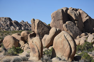
For no particular reason I started off to the west. A rock outcropping with a visible crack is presumably the "split rock" for which the area is named.
It's a two mile loop. There's a spur trail from the southern end of the loop that heads towards Skull Rock. There's also supposed to be a trail that heads off on several spurs to the north and northwest, but I did not see that junction.
The trail takes you past numerous interesting rock outcroppings, some with balaned rocks. Very few Joshua tree. And, because I was there in the dead of summer, not a lot of flowers in bloom.
I saw a few jackrabbits on this trail, and lots of lizards. Besides the rocks, that's about it.
I can imagine some may choose to climb some of the rocks around the area. Many of those might require walking across delicate soils, however. I can also imagine that some of these areas might make good foregrounds for Milky Way nightscapes.
With a moderately early start, I finished with the temperatures still seemingly comfortable. My car thermometer said it was in the low 80s.
Despite these low temperatures, I was somewhat surprised by how few people I saw out in the park, even in the morning. A pair of hikers returned to their car as I headed out, and I think I only passed one other couple while on the loop. Maybe three other cars in the lot, when I got back.
Nice little hike. Since it still wasn't very hot, I wanted to take another short hike. Although this wasn't my original plan, I ended up hiking Lost Horse Valley trail, which was not even on my Trails Illustrated Joshua National Park map. More on this, next time.
A Death Valley Spring | Funerals #5
-
After a spectacular hike up King Midas Canyon, I'd planned to camp
somewhere near the mouth of Monarch Wash - which I've visited the upper end
of in the pa...
7 hours ago


No comments:
Post a Comment