Hiked Saturday, October 5. A full-scale post would take too long, so I'll do a short one, instead.
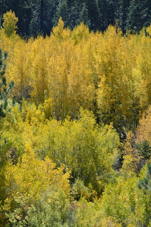
Anyone planning on a trip to the Aspen Grove this year, just wanted to let you know we're around peak color, now. Many of the leaves still have a hint of green, but other trees have already dropped their leaves. I'd say you ought to aim for a visit during the next one to ten days.
In addition to the aspen, oak and willow are also changing color nicely. Nothing quite matches aspen for their yellowness, but both are much more widespread. Along the streams, willow often form the foreground, with aspen in the background. Conifers, of course, provide another, darker contrast with the changing colors of the deciduous trees.
I began this hike right near where Forest Road 1N05 splits off from Road 1N02. In the little triangular area where the two road split is a small parking area. Immediately across the dirt road that is 1N05 from this parking area is a trail head, which is probably the westernmost section of the hiking section of Trail 2E03, the Santa Ana River Trail. Officially, it appears the Santa Ana River Trail is claimed to start about four miles east, where Forest Road 1N02 intersects with the Pacific Crest Trail.
According to the Tom Harrison map, it's about 3/4 of a mile on the Santa Ana River Trail before it intersects with a trail that heads towards the Aspen Grove Trailhead. From the intersection, it's a steep additional 3/4 of a mile. The trail intersects with Road 1N05 maybe 150 yards from the parking area, so there's a short segment of dirt road you need to walk.
From the parking area, it's about 1/4 mile to the crossing of Fish Creek, which is the boundary for the San Gorgonio Wilderness Area, and where the upper section of the Aspen Grove is located.
Once across Fish Creek, the Fish Creek trail heads north (left), and would quickly exit the aspen grove. This is the path I took last month.
However, if you turn right, you are heading downstream, and the aspen grove is thicker this way, and you get a nice backlighting that makes the leaves really pop.
In the past, I only took this trail a 100 yards or so, to get a good view of this grove. Today, however, I continued south. Although the Tom Harrison map only shows a short segment of foot path, in real-life, the trail continues south for at least several miles, apparently running all the way down to Highway 38. (The woman I ran into heading up this trail as I was heading down reported she had started out across the highway from the Wild Horse trailhead. It also turns out that there are several other aspen groves this way, spread out over what seems to be another mile or so.
The woman i chatted with also noted that she had seen a trail branching off this one, and headed up a hill, to the east. I was pretty sure that one would be the one I wanted, and it turned out I was correct. After a brief and steep climb, this trail was again heading back towards my car.
Since some of the trails I walked are not on the trail, my distance traveled is somewhat uncertain. Seemed to take about six hours, but I don't think I went anywhere close to ten miles. I did take over 200 pictures, so it's possible I was simply walking really slow. So maybe as little as 7 miles?
Very nice hike, and very colorful. It was a good day.
Peak 3844 v Gene's Trail Variation - 1/22/26
-
Sue, Kay and Amora on Peak 3844 with Susan behind the Camera
Due to my own convalescence, the Wanderers are just putzing around on easy
trails with Amor...
2 days ago


Wow, excellent photos as always Skyhiker!
ReplyDeleteThanks, Mark. I thought I did okay, until I saw a friend's posts on Facebook! But I still enjoyed the hike.
ReplyDelete