Hiked Thursday, December 31. Final Hike of 2015, although I didn't manage to post it until after midnight.
Wasn't sure where I might wind up for my final hike of the year. My worst-case scenario was that I'd do an after-dark hike in Griffith Park. But I wasn't looking forward to walking in the cold. Fortunately, I got off from work early enough to manage something before sunset.
Monrovia Canyon has several access points from near Mountain Avenue. The southernmost access is on Lemon Avenue, just a bit east of Mountain. There's also one east of Mountain, at Foothill. But I continued on up to Greystone.
Not certain of my total mileage from there. I'd guess about 1.5 to 2.0 miles from there to the park fee station. About 1/2 mile before the fee station is a gate that was locked. It said the park was closed, but there's an opening for hikers to pass around the gate, and I saw plenty of hikers on the road, so I figured it was just closed to motor vehicles, but open to people on foot.
When I did reach the fee station, I saw a couple of photocopied sheets of paper taped on various places, announcing that the park was closed on December 24, December 25, December 31 and January 1, but that hikers were still welcome.
Nice to have that confirmation.
Probably saw 20 or so other hikers on my hike. That's pretty empty compared to many other visits.
On my previous trip up to Monrovia Canyon Park, I noticed that a spur trail that had been closed and under construction since my first visit to this park (back in 2010). That first hike was before I started my blog, although it was one of my first 100 hike year. No write up or post on that original hike, but here's the write-up from
my second visit to the falls, in 2011.
From the fee station to the falls via the falls trail is given by one sign at the trailhead as 1 1/2 miles, and by another as 1 3/4 miles. Add in the extra 1.5 to 2.0 miles from the fee station to Greystone Avenue, plus the 1 mile or so roundtrip from the main trail to the Cunningham Overlook (the spur trail that was open as of my last visit, and was still open, today), and figure it was a total of six miles or so, total. Total walking time was about 2 1/2 hours, which is why I'm thinking it was about about 6 1/2 miles or so, tops.
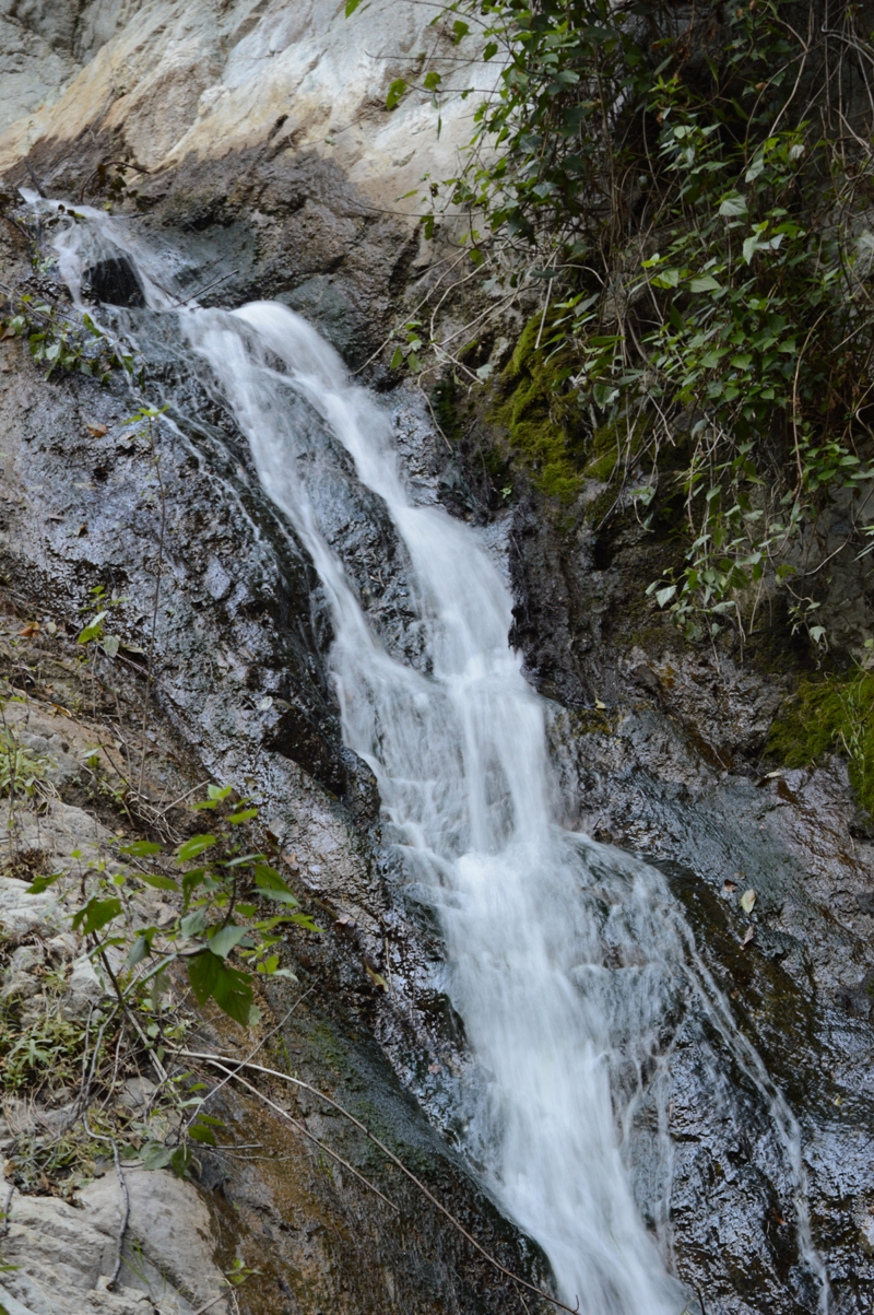
The water is flowing fine. Not as high as after a wet winter, but not bad, considering we're still on the tail end of a multi-year drought. Yes, rain since May has been above average, but average rainfall from May through December is usually not very much. So it was higher than I've seen it, but nowhere near the highest flow I've seen, here.
After finishing my visit to the falls (and after having taken many pictures, of course), I returned back the trail, to the turnoff for the Cunningham Overlook. This one is given as 3/4 mile each way from the entry station. It's no more than 1/4 mile from the start, so the entire spur is only about 1/2 mile, each way, or 1 mile, roundtrip, away from the main trail. In fact, it feels shorter than that.
It is a pretty steep climb for such a short trail, though. At the end is a small green bench. From there, there's a pretty good view to the southeast, and a mostly-open view up canyon, overlooking Monrovia Canyon Dam.
Spent a few minutes there, then returned. Good pace heading downhill. I probably averaged over 3 miles per hour on most of the downhill leg, minus the part heading up to the overlook. Particularly good pace heading down the part of the trail that's right adjacent to the road.
Once off the road, I also moved quickly, but kept scanning around, as is my habit. Up on the berm on the other side of the wash, which I assume is a settling basin, I saw a foursome of deer, silhouetted against the sky. Unfortunately, by the time I got my camera back out of my bag, they were now walking with a less open backdrop, and were harder to see and photograph.
Also, it was getting pretty dark, so even after upping the ISO to 800, the shutter speed was pretty slow, and the deer came out less than sharp.
It's funny how excited I still get to photography deer in a quasi-wild setting, considering how often I have seen them grazing on front lawns in Monrovia, or on the lawn at Griffith Park, or practically swarming around Zion Canyon. So I shot plenty, but most were of those pictures were completely unusable.
Got back to the car some time before 5pm. Sunset was about 4:50pm today, so it was not yet dark. Took surface streets back home, just in case of rush hour / long weekend traffic, and to avoid running into possible parade-related street closures if I had taken the freeway further west before heading south.
Easy hike. Not much of a crescendo to my third year of actually making 100 hikes. And I'm sure my mileage was probably only about 1/2 of my first 100-plus hike year. Still, nice to get some extra activity in. I think the Fitbit helped. Maybe more on that, later. I still have a number of 2015 hikes to blog, and, of course, hope to continue frequent hiking into 2016.
Happy New Year, fellow hikers!


Congrats Skyhiker, you are a hiking machine! Here's to an exploration filled 2016!
ReplyDeleteHey, Mark! Welcome back to the blogosphere! Looking forward to seeing some of the Appalachian Trail.
ReplyDelete