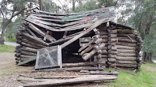
Hiked Saturday, January 16. 5 miles. Wandering route, today. I started from the lower Rubio Canyon access, near the "corner" of Loma Alta Drive and Rubio Canyon Road. I parked on nearby Rubio Crest Drive and walked the 1/10th of a mile or so east, to the access. Headed up canyon, past the old and decaying cabin.
Actually, I don't know if the cabin is actually old. Given its continual decay, I'm assuming it's got no significant historical value, or they'd have stabilized it, by now.
There are various home security and no trespassing signs along the road, but the road itself is a public right of way (no parking on this road, though).
Go past a variety of water supply facilities on both sides of the path, then descend to the wash floor. A trail does head up to the right. Ignore that path, today. Instead, cross over the center of the (usually) dry waterway and head up the path that climbs the opposite bank. This path can be steep in parts. It soon joins the "regular" Rubio Canyon Trail, which starts adjacent to the corner of Rubio Vista Road and Pleasant Ridge Drive. But my way adds a bit of extra distance, which is nice, because the trail itself is pretty short; from the "regular" access point, it's less than a mile to the lower falls (Moss Grotto and Ribbon Rock Falls).
The best overview of Rubio Canyon, in general, that I am aware of is here, on Hiker Dan's hiking page.
I hiked to those lower falls, to see if any water was making it down the falls. None was. So I returned to the foundation of the old pavilion where the incline train headed from Altadena up to Echo Mountain. I followed a trail ("the Incline Trail") about halfway up that incline, at which point a trail veers to the north. ("the Middle Old Echo Mountain Trail").
Staying on that trail would eventually take you up the north side of Echo Mountain ("the Chalet Trail"). However, there are numerous use trails that veer off from it (and the trail itself is not especially obvious). I took one of those detours to a rocky outcropping that overlooks Rubio Canyon, including a reasonably close peek at where Leontine Falls would be, if water were flowing. In fact, I could hear the sound of trickling water, but, could not see any falling water.
After my peek, I headed back to the Chalet Trail, and made my way to the top of Echo Mountain. The clouds that had been around for most of the day were starting to break up, just a little. Nice, dramatic views of the peaks above Rubio Canyon.
Once at the top, I snapped a number of pictures. As is typical on a weekend, the "peak" was quite crowded. It's not really much of a "peak," but it is neat, with all the foundations and remains of the old "White City," which was once a mountain resort, in the hills above Altadena.
Lots of separate groups, enjoying the outdoors. Only one group, which I later caught up to, but which I had heard several times from quite far away, was being obnoxiously loud.
I started down the Sam Merrill Trail, the one most folks take up here, which starts at the north end of Lake Avenue, in Altadena.
Almost as soon as I started down, I was back within earshot of the loud people. "Earshot" means, basically, on the same side of the mountains, because they were really loud. I hate people like that. Music playing, shouting, screaming. Rude.
At about the halfway point (where the trail passes under the power line towers), I diverted off the Sam Merrill and on to the "Old Lower Echo Mountain Trail." All of these names, by the way, are from the little maps put together by the Arroyos and Foothills Conservancy. I don't think their maps are available on line, but they are often in a little "mailbox" at the "regular" Rubio Canyon trailhead, which is north of 1342 Rubio Vista Road, in Altadena.
This trail is steep, though not nearly as steep as the Incline Trail. After probably 3/4 of a mile, it joins with the Rubio Canyon Trail. I headed a bit up canyon after I met that trail, to take the Lower Rubio Canyon Trail, which heads to where the canyon runs into Rubio Canyon Road. Walked from there back to my car. I'm calling it five miles, though it's possible it was more. Decent distance, anyway, and a chance to see if the water had returned to Rubio Canyon. It hadn't, so I'll have to return again after (hopefully) several more significant storms have made their way through southern California.
It's a slow start to El Niño.
A Cold Morning on Chloride Cliffs | Funerals #3
-
I inched toward the edge of the cliff under cover of darkness. My
super-bright, bumper-mounted Diode Dynamics SS5 lights cut multi-mile-long
daggers into t...
11 hours ago


