(Picture 1: Icebox Canyon waterfall). Hiked Saturday, February 2.
After returning (not entirely by design) to my car from Lost Canyon, I immediately set out again for Icebox Canyon. That's the next canyon you encounter in the counterclockwise drive around the Scenic Drive.
BTW, that means Red Rock Canyon is a misnomer. It's not one canyon. It's a place where easily half-a-dozen different canyons open up out of the surrounding hills and on to a place that is undoubtedly stacked high with the alluvial materials from those many drainages. I guess, in a sense, standing in "Red Rock Canyon" means you're standing on top of the Spring Mountains, the La Madre Mountains, and the Sandstone Bluffs, all at the same time.
(Picture 2: Lost Canyon wash). In any event, rather than driving my car the mile or so further along the road, I just walked the connecting SMYC trail (no, I saw no indication of what SMYC stood for). If I had to guess, it's probably the initials of the guys who built the trail), to the southeast. It more or less parallels about one mile of the face of the bluffs that form the west boundary to what people normally think of as "Red Rock Canyon." These are not the steepest or most multi-colored sections of cliff, but they're still nice.
(Picture 3: Turtlehead and La Madre). As the trail makes this lateral, it does not stay level. First, it drops down into, and crosses, a wash. Parts of the wash are dry, but, in other areas, the water from Lost Canyon springs flows on by (See Picture 2).
(Picture 4: Cholla cactus). Later, the trail begins a bit of a climb. Before long, you can see over the intervening alluvial fan, and look upon Turtlehead Peak and the southernmost part of La Madre Peak, off in the northeast, on the other side of the scenic drive loop (See Picture 3).
Once past the outcroppings, the trail heads annoyingly close to the parking area for Icebox Canyon. That means it's a longer walk that it has to be, because you give away a lot of altitude that you'll just have to gain all over again when you get on to the actual Icebox Canyon Trail.
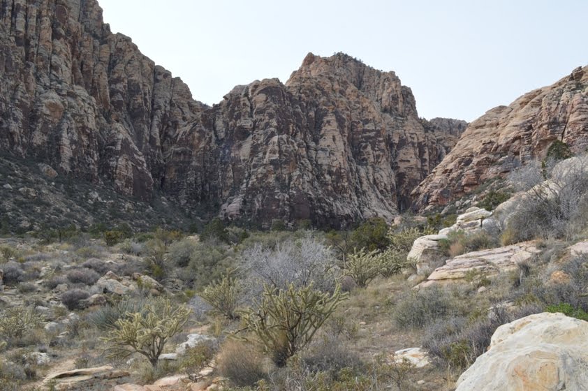
(Picture 5: Looking into Icebox Canyon). As you approach the Icebox Canyon Trail, Cholla cactus become somewhat plentiful. I love those cactus; they look so wonderful when they've got a little backlighting on them.
Finally, I reached the Icebox Canyon Trail. Icebox Canyon was now above and head of me. The rocks were covered in desert varnish. (see Picture 5).
(Picture 6: A millipede). That trail, like many I have en-countered in Red Rock, is difficult to follow, as many parallel and crossing paths are intertwined as you head into the canyon. I think the actual trail is supposed to hug the edge of the ravine, on your left.
(Picture 7: A tighter view into Icebox Canyon). In contrast to my walk along the connector trail, the flow of bodies along the Icebox Canyon trail was pretty constant. I also came across a short millipede (See Picture 6), which reminded me of the veritable swarm of them I saw in
Petroglyph National Park last year.
Eventually, I reached a point where the dark stain of water seeps were on my right (See Picture 8). My impression is that many people turn around here, because, next, the trail drops into the ravine and makes a series of rocky hops, occasional scrambles, and poking of the way around obstructions in the canyon bottom to continue.
(Picture 8: Seep into Icebox Canyon). After another 1/4 mile or so, I could hear the sound of running water, dropping between the piles of rocks in along the canyon walls. Soon, I rose to see a sizable pool of water (See Picture 9). Passage directly up the canyon was blocked here, but a relatively easy class 3 path was possible behind a pine tree on the left. The tree provide fall protection as you scrambled up the rocks.
From there, you had to walk with a 10 or so foot drop off into the pool of water on your right. But the rock had somewhat level pathways, and was still pretty grippy for my lugged soles to navigate. It's not a big drop, but clearly many people stop their hike here.
(Picture 9: Pool before the falls). After the fifteen or so yards of exposed scuttling, I was back on a solid surface.
Another pool of water was here, and a narrow sluice of water zipped in from another pool, above (See Picture 1).
Climbing that little falls would not be too difficult, but the exposure and possibility of a wet fall into the pool, plus seeing that there would be no further advancement beyond that pool, convinced me to enjoy this falls from below.
(Picture 10: Dried redbud seed pods). It's a pretty sight, but the lack of direct light reduces the contrast between the water and the rocks, so I don't think the pictures do it justice.
I returned the way I came. Just below the falls was what looked like a western redbud tree, with seed pods still hanging on (See Picture 10). I bet this place would look beautiful in the early spring, when those redbuds are in bloom.
About 4.7 miles for this segment of hiking. Moderately strenuous, except for the last 100 yards or so. That part will take a little coordination and an ability to walk along a small dropoff. Probably not dog-friendly or child-friendly for that section.


No comments:
Post a Comment