Hiked Saturday, May 4.
This is a hike from over two months ago, that I never quite finished blogging about. This is also before the format for my posts changed. I don't know why it changed, but instead of giving me small pictures like here, they've been giving me oversized pictures. Not sure what I clicked on to change it, but I prefer this older format.
It was a pleasant surprise of a hike, because, despite over three years of trying to do 100 hikes a year, and despite this one being only about ten miles from home, I had never done it before. However, while hike the
Altadena Crest Trail in early April, someone I ran into mentioned this trail. So, on the day of this hike, that recollection returned, and off I went, to Millard Canyon.
There's a waterfall in Millard Canyon, but the trail to the base of that weaterfall has been closed since the winter after the Station Fire. As a result, the parking lot down in Millard is almost always mostly empty. Most of the trails you can access from there, you can access from elsewhere, and either not need an Adventure Pass or have several hundred fewer feet of altitude to gain to get out of the canyon.
Despite the empty parking lot, I ran into plenty of trail users. Most were mountain bikers, many of whom like to ride fast. Fortunately, my hearings pretty good, and, since I'm hiking by myself, I can usually hear them before I can see them (and they can see me), so I can step off to the side before the bikes reach me.
And step aside you must. For, one thing I have noticed about the Angeles: Just 'cause they call it a "truck trail" doesn't mean it's going to be wide.
In this case, the generally flat area was relatively wide, but the area free of plant growth and suitable for hiking or biking was very narrow. It has obviously been a number of years since a truck has actually driven the length of the road, I would guess.
The parking area for the trailhead is at the end of Chaney Trail Road. Chaney Trail heads north, off of Loma Alta Road, and is about 1/3 mile west of Fair Oaks, and about 1/2 mile east of Lincoln.
An Adventure Pass is required to park in the lot, and along most of the rest of Chaney Trail Road, once you get into the hills. At the crest of a hill, before you descend into Millard Canyon, there's a stub of a road where people interested in hiking the Sunset Ridge trail (towards Echo Mountain and/or Mount Lowe) will park. That area is often pretty crowded (much more so than at the bottom of the canyon).
To get to Brown Mountain Truck Trail, stay on the paved road (do not park in the stub of a road at the crest) and continue down into Millard Canyon. On most of this road, there is no line in the center, and it's winding and narrow, so drive slow. In addition to cars, you need to be on the look out for bikes and hikers, in addition to the occasional fallen rock.
Once at the bottom of the Canyon, the road heads into the parking lot, with room for about twenty cars. Brown Mountain Road is the gated dirt road on the near (northeast) side of the parking lot. There's another gated dirt road that starts off from the southwest side of the lot, but I did not investigate where or how far that road goes.
Basically, you start out as though you are either heading towards Millard Canyon Falls, or as if you were going to take the trail back up towards the Sunset Ridge Trail. You'll pass by the fenced off section that forbids entry further up Millard Canyon, passing the caretaker's trailer along the way. There are several cabins down here, apparently inhabited year-round. Pass them as the road winds to the south and begins gaining altitude.
Once on the main road, you generally bear to the right. Do not go down the narrow bike trail you pass within the first 1/4 mile or so, on your left. Do not take a diversion on to a dirt road further up the mountain, either. Both would take you down, towards JPL. Instead, just go up, stay on the "main" road, and head into the hills.
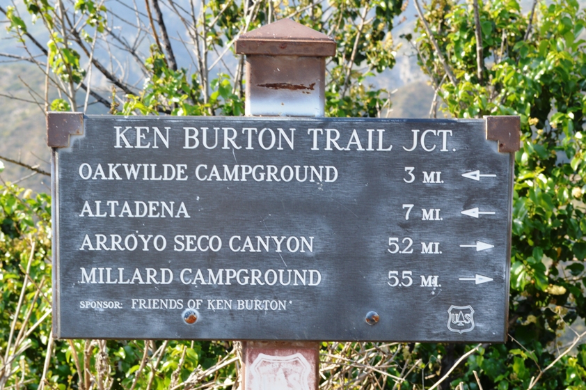
I passed two trail signs with distances along the way. The first said I had gone 2.9 miles from Millard Campground, and the second said I had gone 5.5 miles. The second also said I was at the Ken Burton Trailhead.
After I got back home, I looked at my Tom Harrison Angeles Front Country Trail Map and easily traced my route. I could see that I started at about 1800 feet and ended at about 2900 feet. This means it's a pretty low altitude hike, and more fitting for spring than for summer. Fortunately, on the day I hiked, it was pretty cool.
At the end of the trail, you're rewarded with a rather impressive view into the Angeles National Forest. Several views of Angeles Crest Highway are also available on your way up.
At the time of the hike, there were quite a bit of wild-flowers. I image things are a lot drier, now. As I mentioned earlier, this seems like a spring hike rather than a summer hike.
I also mentioned that this hike could (apparent-ly) be linked with JPL. I've never hiked out of JPL, but, despite the guarded gate, I am told there are certain hikes they'll let you go to. You should probably consult additional sources for where and when you can hike out of that area, though. And, if you find out, feel free to post here so I'll know, too!


No comments:
Post a Comment