Hiked Saturday, November 9.
I had hiked here once before, now over three-and-a-half years ago. Follow that link for details on the getting to the hiking trail. One difference from then is that, as far as I am aware, a USFS Adventure Pass is no longer required to park at the trailhead. Adventure Pass can only be required at "improved' day use areas, with picnic tables, toilets, and the like. Since this trailhead has no improvements, it is not subject to a fee.
More recently, I saw a write-up of a fall hike here, and was impressed by the fall foliage. So my plan was to try to get back to here some time before the end of fall foliage season.
Well, it turns out this weekend was pretty much the edge of the season. There are still many sycamore holding golden yellow foliage, but those trees are turning bare quite quickly.
It's been a dry year, so I would not expect the leaves to hold too long.
Also, to see the best foliage would, I think, require walking among the cabins, and a very loud dog was barking at me as I passed, so I decided to stay on the main trail.
Despite having been here only one time before, I did recollect my route to the trailhead. After making the tight turn off of Mount Baldy Road, I made the sharp right and parked under the trees near the powerplant.
If that small lot were full, there's another large parking area maybe 1/10th of a mile down the road, in the rocky wash.
Cars with high clearance could probably drive an additional mile or so, to near the gate on this road, which is right after the cabins. I'm not 100% sure about that, and I don't have a higher clearance vehicle, so it was a moot point for me.
I started my hike before 9am. The sun was still just making its way over the ridge, and most of the early portion of the hike was in shadow. I got some interesting raking light as it shined over that ridge, with shadows of tall trees stretching down the hill.
After crossing San Antonio Creek, the dirt road begins a mostly southerly climb, keeping the canyon to your right. It's a fair incline, but the altitude is low and the walk was pretty easy.
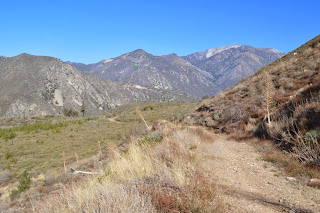
I could look to the north, up canyon, and see Mt. Baldy and its tall friends. I could look west, across the canyon, over look Mt. Baldy Road, and see the San Gabriel Mountains stretch off in the distance. Or I could look south, down canyon, towards Claremount. As last time I was here, the sky to the south was hazy, and the view was highly obstructed.
The main foliage area is just around the cabins. A small creek runs south off the high peaks and runs right through this little "village" of maybe a dozen cabins. Sycamore were thick here, as was the sound of running water. However, it being morning, the light did not yet reach this area, so I did not take many foliage shots here. What I did take I took on my return let, closer to noon.
After the cabins and the gate, the trail continues climbing, still mostly shaded and comfort-able on this day. It's probably a bit over a mile past the gate that the road crests at Stoddard Flats. From there, a thin trail peels off to the right, along the ridge. In this picture, you can see the trail, starting about midway top-to-bottom, and maybe 1/4 of the way from the right side of the picture.
There's usually a small pile of rocks where that trail heads into the foliage. The foliage is slightly prickly, and there's a fair amount of bayonet yucca near here, too. Still, in shorts today, I had no problem navigating my way along this short but steep segment to the ridge line.
From there, you just follow the ridge line. I stopped a little short of the actual peak today, because the hazy made it clear there would be no view payoff to be had by continuing further this way.
I enjoyed the view for maybe ten minutes, then turned around. I was also feeling pretty good about myself, thinking that, for the distance I had traveled, I was feeling strong.
On the other hand, I did have some stumbles and trips on my short decent back to Stoddard Flats. Also, I later determined (and confirmed when I got home) that this was a six mile roundtrip hike, not one way. Of course, that explained why I was feeling so strong on the way home. ;D
Still a couple of hikes from this year I haven't blogged, though they don't cover any new terrain. Not sure if I'll blog them or not.
A Cold Morning on Chloride Cliffs | Funerals #3
-
I inched toward the edge of the cliff under cover of darkness. My
super-bright, bumper-mounted Diode Dynamics SS5 lights cut multi-mile-long
daggers into t...
11 hours ago


Brings back memories of my hike there. Wow, it's been 8 years.
ReplyDeletehttp://www.simpsoncity.com/hiking/stoddard.html
Time flies as we get older. . . . ;D
ReplyDelete