Thursday, December 12, 2013

Hike 2013.056 -- Eaton Canyon Falls from Eaton Canyon Nature Center

Hiked Monday, December 9. Well, I'm largely down to single hikes in a week, which is a real shame. As I noted in my previous post, my work schedule is really limiting my hiking opportunities. Also, probably because I've gotten out of the habit of three or four hikes in many weeks, it's sometimes hard for me to feel the motivation to get off my butt and into the mountains.

On this day, I took a vacation day from my regular day job so I'd have time to work on writing a test for one of my night jobs. Unfortunately, I didn't get nearly as much of that done as I wanted, so I'll be spending a good part of the upcoming weekend trying to get that done.

With the whole day off, the plan was to start the day with a short hike. I waited long enough for the sun to rise and get the temperatures out of the 30s and probably out of the 40s. Then I took a very short, very easy, but scenic hike into Eaton Canyon.

Being a weekday, the parking lot at Eaton Canyon Nature Center (Altadena Drive, just north of New York Avenue, in the "Altadena" portion of unincorporated Los Angeles County) still had plenty of spaces. But it was far from empty.

I walked at a fast clip, as I've done this hike so many times before. My real interest often comes down to wondering how the falls look this time compared to previous times.

One clue to how the falls will look is to see how far down the canyon the water flows. Today, the answer was, "Barely out past the bridge."
Somewhat surprisingly, however, the water was not even continuous from the falls to the bridge. Not more than 100 yards past the bridge, the river bed was dry. And it stayed dry until not more than 100 yards from the falls. I was surprised. But it's been a while since my last hike, so I don't know how low the water was before the recent rains. But, clearly, it must have been dry.

I took plenty of pictures, then returned the way I came. About four miles roundtrip.

Additional write-ups of this hike elsewhere on this blog would provide more detailed driving directions. There isn't much to add to the hiking directions, though. You just go "up-wash," until you reach the falls.

Sunday, December 8, 2013

Hike 2013.055 -- Monrovia Canyon -- 935 Lemon Avenue to Monrovia Falls

Hiked Saturday, December 7. The day started with rain, which I didn't mind. I brought rain pants in case the rain was heavy, though, by the time I got to the "trailhead," the rain was mostly over.

I started the hike at 935 East Lemon Avenue, in Monrovia, CA. This is the southern terminus of the Sawpit Wash trail, which parallels the concrete drainage ditch that is Sawpit Wash as it passes through Monrovia. It's roughly six miles, roundtrip.

There's a pretty Craftsman house at this address, with a cute mailbox.

To get to the trailhead, take the Foothill Freeway (I-210) and exit at Mountain Avenue (just west of the San Gabriel River Freeway, I-605). Either direction you're coming from, you'll first exit on to a frontage road before running into Mountain Avenue. Turn north (towards the mountains) at Mountain Avenue. After passing Huntington Drive, Lemon will be the second traffic light. Some day in the future, you'll also have the option of taking the Gold Line to Mountain Avenue Station, then either walking north from there, or possibly catching a local bus.

Your trail will start on the north side of Lemon, on the east side of the wash. Your first mile and a half or so will be along this wash, and is less than scenic. Still, there are mature oaks along the trail, and some nice farm buildings and open fields to admire along the way. This approach also extends your hike a bit, to make the walking distance more worthwhile, and eliminates the 1/4 mile of non-shoulder road walking you need to make if you park near North Canyon and Ridgeside.

If you wish to avoid this additional walking distance, you can drive right into the park for $5 and have a short, 1 mile roundtrip hike from the Cabin Trailhead, or a three-mile roundtrip hike from the entrance station trailhead. Or you can save $5 and park near the intersection of North Canyon Blvd and Ridgeside Drive, for a four-mile roundtrip.

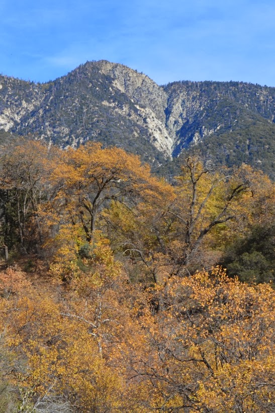
Low clouds and cool tempera-tures were my companion on this hike, and that created some nice, ghostly views of the trees and hilltops up the canyon.

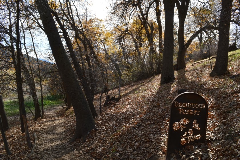
At the entrance station (which also has a nearby flush toilet, the only facilities you will walk by on this hike--although there are other benches, a small museum, and another toilet if you leave the trail and head out of the canyon at the final trailhead). Bright red berries were common here.

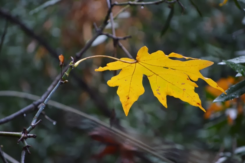
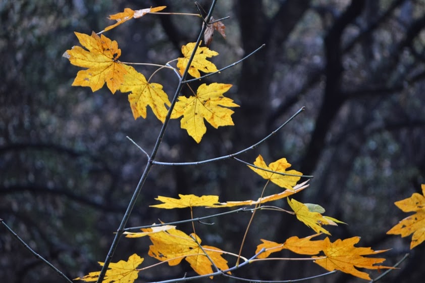
The main color on this hike was the sycamore trees that are common in the moister ravines along the way. I took well over 50 shots of just the leaves along the way. A particularly scenic spot was just before I joined the main trail that runs up the canyon from the in-park trailheads. Those pictures are further down in this post.

Although it had rained earlier that morning, the water was not running especially high. It was above average in flow, but not roaring. It was definitely pretty, however.

Not only was the view nice, but I had it to myself, at least for a period of time. On many weekends, there'll be dozens of people packed along this little falls. Today, I ran into exactly one couple coming back from the falls, and I knew I had one pair of hikers not far behind me. But while taking well over 200 photos on this hike (and so, moving very slowly), no one had yet passed me. That's how empty it was.

It almost seems like a crime that so few were here to enjoy these beautiful sights. However, the rain and atypically cool (for the L.A. area) temperatures clearly kept most people out of the canyon. Or maybe Christmas sales was the attraction that held them in town?

What ever the reason, I had time to take about a dozen shots, with various framing and shutter speeds. Knowing there were people coming soon, I still did rush myself a little. But it was still probably the most time I've had alone at these falls.
Plenty of grey squirrels in this canyon. They've got really bushy tails. They've also been largely displaced in much of southern California by brown squirrels from the East. Yet, here, they seem to be doing well.

I hiked the return somewhat quicker than the way out, at least for the most part. I still stuck around the colorful leaf areas, and also shot a number of down-canyon photos.

Unlike on the way up, I did pass a number of people heading down. It was still a relatively small number, though. Might even have stayed in single digits within the park.

One half of a couple asked me some questions about my blog (because she was wondering what I was going to do with the estimated 300 photos I shot this day). It got me to thinking a little bit about my past three years of hiking.

This blog was born back in early 2010. Officially un-employed at the end of the previous Septem-ber, I had already spent over a year looking for new employment, without success. I had come across a local newspaper article about a local guy who was wrapping up his 100 hikes before the end of the year (he had started about 1/3 of the way into the year), and it got me to thinking about setting a goal to achieve during what was starting to look like an extended period of unemployment.

In fact, I had the "good fortune" to be unem-ployed at the start of "The Great Reces-sion." The recession was particularly tough for people in my line of work, so remained unemployed for much longer than I thought I would be. Yet, because so many people were in the same boat as me, unemployment and health insurance benefits had been extended repeatedly, allowing me to stay in my house.

That first year was mostly hiking in the San Gabriel Mountains and the Puente Hills. I started in the low country, then slowly went to higher altitudes as the weather warmed. All told, I managed 109 hikes that year, as well as a good number of job interviews that, unfortunately, nearly all ended with the hiring officials deciding that I was "overqualified."

In 2011, while still unemploy-ed, I expanded both my hiking territory and my job search. I did a number of hikes in the Santa Monica Mountains, and applied for a number of one-year positions out of state. I wound up accepting a temporary position at Murray State University.

That turned out to be both a good and a bad four months far from home. Good colleagues, lots of hiking opportunities, and an outstanding astronomy club, but a tough year. That's the last year I actually managed 100 hikes. About a half-dozen of those were on the drive coming and going to Kentucky.

In 2012, I managed just 79 clubs. I started and ended that year working two jobs, and that just made fitting in the hikes unfeasible. Not enough days in a week.

This year has been even worse, from a hiking perspective. I'll barely break 60. I started this year working two jobs, and picked up a second part-time job (well, thanks to an improved budgetary picture, got to teach some classes at the same local college I taught at back in January 2012). Three jobs don't leave much time for hiking.
Other personal develop-ments have made this a tough year. And I'm trying to figure out what I can do to make it better. On the one hand, the current money's great. Thanks to low interest rates on my refinanced mortgage, it's better than it's ever been. And, while none of the jobs I have are intrinsically stressful, the combination of jobs is wearing me thin (figuratively, unfortunately, not literally!--I've also gained 20 pounds in the past six months. That's unacceptable.

At any rate, next semester's schedule is mostly set, and I'm going to do my best to improve my eating habits. Then, come summertime, I'll have time to maybe figure out what, next.

Monday, December 2, 2013

Hike 2013.054 -- Oak Glen Preserve (Wildlands Conservancy), Riley's at Los Rios Rancho, Oak Glen (Yucaipa), CA

Hiked Sunday, December 1. 4.5 miles. It seems like this must be a mistake, but, according to my blog, it's over three years since my last walk in the Oak Glen Preserve. It seems like I must have hiked more recently, but I have no blog entries to prove otherwise.

The good news is, in the past few years, The Wildlands Conservan-cy has built several new trails in the area. It's now easy to assemble a hike of 4-5 miles or more without needing to retrace significant parts of your walk.

The trail-head is at Riley's at Riley's at Los Rios Rancho, which is located at 39611 S. Oak Glen Road, Oak Glen (Yucaipa), CA 92399. From the West take the San Bernardino Freeway (I-10) east. Approximately five miles after passing the CA-210 interchange, exit on Yucaipa Blvd and head east (left). There are numerous restaurants along the next few miles of road, if you decide you're too hungry to continue.

After about 2 1/2 miles on Yucaipa Blvd, turn left on Oak Glen Road. Drive approximately 9 miles on Oak Glen Road, and look for Rileys at Los Rios Rancho, which will be on your right. The trailhead will be at the right end of the paved overflow parking lot that is to the right (as you enter) of the main lot.

The first thing I saw on my hike were some large birds, circling in the distance. Looking at the pictures, they look to me like white pelicans. After several orbits, they made their way east, above the mountains of Yucaipa Ridge, which is north of Oak Glen.

Next up were the two ponds, both picturesque, and lined by reeds, and by trees holding on to the end of autumn with all their might. At the upper pond, the Yucaipa Ridge was reflected in the glassy surface. On both, waterfowl swam upon and flew above the waters.

It's only about 1/4 mile from the trailhead to these two ponds. One could probably spend hours there, being still, and set with their camera to capture the unfolding of events here. However, I stayed only a few moments before continuing on my way. This meant backtracking my steps, now heading, I believe, to the southeast. The late morning sun was already hidden by the taller trees along this walk (albeit only partially, as most had dropped most of their leaves by now). This provided for some nice backlit pictures, which regular visitors to this blog may have discovered I just absolutely love.

The stream trail now descends along a broad old dirt road, with large oaks curving upon the way. About 1/3 mile down this way, the Chaparral trail splits off to the right, climbing a bit along the ridge here to provide a bird's eye view of Los Rios Rancho and the surrounding lands. It's not nearly as impressive from here as it would be from the trail to Preserve Point, which I would take later.

After the 1/3 mile or so detour up upon this hill, the Chaparral trail then drops back and rejoins the Stream Trail, not 100 yards further down from where you left. So this detour adds a bit of distance and altitude gain to an otherwise short jaunt.

I followed the Stream trail to its end, in a picnic area. From there, direction trail signs point out that it is .9 miles back to the trailhead from where you now stand (I assume this is taking the Stream trail, though the Boardwalk trail is probably essentially the same distance). It also tells you it's 1 mile to Preservation Point (straight at the sign), or .6 miles to return to the trailhead by continuing the loop (left at the sign). That would make a direct hike from the trailhead to Preservation Point and back as 3.8 miles. Add in the detour for the ponds and the Chaparral Loop, and that's the basis for my estimate of 4.5 miles for the day.

I decided to head up to Preserve Point. This trail is somewhat steep, and not nearly as well-trod as the trails you leave behind. Unfortunately, I'm also in poorer shape than I was a few years ago, so this little one mile climb sure seemed to be twice that long.

If I understood the Wildlands Conservancy ranger I spoke to after the fact, you need to follow this trail up to the ridge (which has several false 'summits'), then head north, to a gate. On the otherside of the gate is a sign saying the place you came from is private property (Rileys Los Rios Rancho, I assume). That would seem to suggest that the land on the other side of the gate is either owned by someone else or is public property.

If you were to cross through the gate, there's a dirt road not far beyond. I believe that dirt road rounds its way towards a nearby high point. Actually getting to that high point would require going on private land, but it was noted by someone (not the ranger) that the high point is owned by a utility and not normally subject to enforcement. But, technically, going there would still be trespassing.

Well, since I was already pretty tired (sad, I know) from the short but strenuous climb, and I was actually thinking I must have gone far beyond Preservation Point (which is not signed on the ground), I turned around here.

In later speaking to the ranger, it seems this area next to the gate is Preservation Point.

From there, and from the trail below, you've got some pretty impressive views. Far to the southeast is Mt. San Jacinto. More towards the south or southwest is Beaumont. Beyond Beaumont is a large reservoir, which would appear to be Lake Perris, which I identified by the large island in the reservoir.

The first photo of this post also came from near the climb up towards Preservation Point. I loved the rustic-looking farm houses and the pastures, orchards, and fields to the east-northeast.

It was a clear day, so the views through out the hike were outstand-ing. It was also a bit warm for the long sleeves I was wearing. This trail must be a killer in the summer.

I returned the way I came, retracing most of my footsteps, except I choose to take the Boardwalk trail on the return leg.

Great day for hiking.

The Wildlands Conservancy also manages Whitewater Preserve, where I have hiked before, and several other Preserves, where I have not been. Feeling so invigorated by my hike, I splurged and donated $20 for their coffee table book of the various preserves they manage.

Thursday, November 28, 2013

Hike 2013.052 -- Chino Hills State Park -- Bane Road, Bane Ridge Trail, Longwayaround Trail, East Fence Line Trail

Hiked Sunday, November 17. The week before my rain-soaked Red Rock Canyon hikes (Ice Box Canyon and Calico Hills/Lost Canyon), I hiked in Chino Hills State Park. Chino Hills is no Red Rock Canyon.

This was my fourth visit to Chino Hills State Park, and the third trailhead. My first visit was from Rim Crest Trail, which I hiked to San Juan Hill and Gillman Peak. The second trailhead was from Carbon Canyon, where the new Discovery Center visitor center is near the start of the trail.

This day's hike was from 4721 Sapphire Road. From this address, Bane Road heads south, into the park. This used to be the only way for the public to drive into the park. However, the road is being reconstructed (I don't know if it is going to be paved, but I would think so), and is closed to motor vehicles. However, with the construction season over, the road is now open for hiking, biking, and equestrian users.

Getting to the trailhead, I took CA-71 (the Chino Valley Freeway), a mostly-limited access route from I-10 (the San Bernardino Freeway) past the Pomona Freeway (CA-60), and on to the Riverside Freeway (CA-91). From CA-71, take Soquel Canyon Parkway, west. As you pass Butterfield Ranch Road, you'll see a shopping area to your right. This is the last facilities you'll see, as there's no restrooms or other facilities at the trailhead.

After Butterfield Ranch Road, continue west on Soquel Canyon Road for about 3/5 of a mile. A sign will direct you to a left turn, at Elinvar Road. After about 1/4 mile, Elinvar ends, a you must a make a 90-degree left turn, where the street changes name to Sapphire Road.

Bane Canyon Road enters immediately, on your right. Park anywhere in this area, though check to make sure you are parking on a street sweeping day. If so, park on the other side of the road.

On the day I hiked, there was a small pocket for maps near the entrance gate. It's an old map, however (dated 2002), so it has no update on what's going on with this road.

Hike on up the road. Expect mountain bikers on this, and nearly any of the trails.

North is to your back. South is straight ahead. Hills rise on either side. If it's clear, you can look back and see the San Gabriel Mountains. In the winter, they may be blanketed in snow.

The actual Chino Hills, however, are far too low for snow. Visit in the spring, and it's green rolling hills, or rolling hills covered in growing weeds (meaning, non-native plants). In the late summer or fall, it's mostly brown. Today, a few live oak were still green. Willow were mostly green, with a touch of yellow moving in. The sycamore were drier, with fewer leaves. Tree tobacco was also still growing green.

There was also the occasional bit of growth closer to the ground. A few bushes of sunflower, a few areas covered by datura, and a very few other sort of flowering plants. But it was mostly just dead grass. Not very scenic, other than that there were rolling hills of almost nothing, which is kind of rare in southern California.

Because of the lack of color, photo-graphing here is almost like a throwback exercise in shadows and light. Patterns attract your attention, but the patterns are mostly just variations of brown, or, as I said, of shadow and light. There was also the blue sky and the puffy white clouds. But that's about it.

On my hike this day, once I cleared the first rise, I took a trail heading to my right. It was the Bane Ridge Trail. I figured the view would be nice from up there.

Probably earlier than I intended, I descended past a powerline tower and joined the Bane Canyon Trail. I followed it for what seemed like at least 1/2 mile, eventually reaching some benches. From there, I stopped and studied my map some. Then I backtracked a bit to catch the "Longwayaround" trail, which would take me to McLean Overlook.

As I approached the viewpoint, I noticed an impressive outcropping. After first continuing to the viewpoint and looking in all directions at the rolling hills, I returned back to the side trail that would take me over the outcropping. This was the East Fence Line Trail.

This trail winds its way SLOWLY, and with many ups and downs and much following of ravine contour lines, followed by climbs into the next watershed. Eventually, the East Fenceline trail rejoins the Bane Canyon Trail, just 1/2 mile from Sapphire Road, and pretty much directly across the trail from where the Bane Ridge Trail had separated from Bane Canyon Trail in the other direction.

Hard to estimate total mileage, because that East Fenceline Trail really made a lot of turns. Anywhere from 6 to 8 miles of walking would be possible. I'll call it 7 miles for the day.

Good exercise, new territory covered, but not exactly outstanding scenery, and not significantly different from the landscape you see from the other trailheads.

The only other place I haven't been to in this park is the area down to the southwest, in Aliso Canyon. I'll have to try to find a good trailhead for that portion.

Sunday, November 24, 2013

Hike 2013.053B -- Icebox Canyon Waterfalls, Red Rock Canyon National Conservation Area, NV

Hiked Saturday, November 23.

When I left the L.A. area on Friday morning, a fresh, pretty coat of snow blanketed the high peaks near Mt. Baldy. When I left Las Vegas on Sunday morning, an even thicker blanket covered the Spring Mountains and on over to Mountain Pass. In between, at the altitude of Red Rock Canyon National Conservation Area, rain fell. Lots of it.

On Saturday afternoon, I hiked briefly around the Calico Hills. Wrote that up here. On Saturday morning, I arrived at Red Rock Canyon around 9am, which is not early, but before most folks get to Red Rock. Got on the 13-mile loop, and drove past the Calico Hills as I began my drive.

While water ran down the hills like yesterday, the flows were not nearly as impressive as the day before. The rain seemed comparable, but I guess lacked a heavy downpour that must have hit the area before I got there on Friday.

I drove on, to the Ice Box Canyon trailhead. The rain continued, and, in fact, fell until I was nearly back to the car at the end of the hike.

Because of the larger drainage area for Ice Box Canyon versus the Calico Hills, I was confident I'd have something to see.

I had been in Ice Box Canyon last February. Then, the lower of the two waterfalls at the end of the hike was but a thin sluice of water, while the upper falls was but a seep. A few other seeps could be seen on the walls on the way in. And this was during the part of the season when the falls normally run.

This time, there were many falls entering the canyon from both sides. All are undoubtedly temporary, only visible during actual rainfall. Most were not that large, but one near the entrance to the canyon thundered down several hundred feet off a cliff. It reminded me of Upper Yosemite Falls, albeit from a distance. No easy way to the base seemed apparent. I though of perhaps trying to approach it on the way back, but was way too beat when that happened.

So my hike began on a high note. Photography, however, was tough. With rain falling a second day in a row, I kept a microfiber cloth in my coat pocket, and regularly wiped the lens. Still, there were many photos that were ruined by drops on my lens filter.

The trail begins clearly enough, but numerous use trails make it really impossible to stick on the true trail. Also, there have been obvious improvements (large rocks embedded to provide stair steps up some inclines), often within sight of each other, but mutually exclusive. in other words, what trailbuilding they've done has not reduced off-trail use, but increased it, because it creates a crazy mish-mash of crisscrossing trails.

The general goal is to stay near the ridge as you make the first mile of walking. Eventually, you reach what is undoubtedly an illegal cross/memorial for something or someone. That's the end of the "improved" trail. After that, you descend to your left, towards the wash bottom, and head upstream.

In normal weather, that's a dry wash bed you walk your way up. However, on this hike, it was a roaring river. It would rarely be more than knee deep, but it was deep enough and wide enough that crossing the water at spots proved tricky. This is particularly true since the normal route is up the riverbed. So if you need to go around the river bed, the trail is not always defined, or even extant.

More than a few times, I crossed the water, went up a short segment of apparent trail, then either had to bushwhack through thick foliage or admit defeat and work my way back down to the water. When you bushwhack, rubbing your clothes against rain-covered leaves, you get wet. I got REALLY wet. By the end, I was completely saturated, both inside and outside my jacket.

Of course, I expected that, but figured the hike was short enough that I could get there and back to the car before heat loss became an actual issue.

It was tiring going with lots of scrambling up rocks and trying to ease my way down the other side, or hopping on rocks and trying to keep my boots dry. At one point, after several alternate routes failed, I finally had to take my boots off and wade across a short segment of water. This was just near the end.

Finally, I was there. And I was not disappointed. The lower falls curved a nice reversed "C" shape, looking a little bit like a mirror image of falls on the Middle Fork of Lytle Creek. By contrast, as the last photo here shows, last time, that bit was just a thin sluice of a trickle. You can also see a couple of hikers adjacent to those falls, to put the size of the falls in context.

Even more impressive was the upper falls, coming over the lip of an overhang, and free-falling 80 or 100 feet down into the alcove.

There is a middle falls that you can only see from the top of the lower falls, which I did not hike to). Instead, I took many pictures from near the lower falls, then made my way back. It was the most tired I ever felt after an allegedly less than 3 miles of walking.

When I got back "home," I took a warm shower and wrapped myself up in some blankets. Tired. But happy I was able to walk on such a beautiful day in Red Rock Canyon.

Today, as I write this, my arms are still tired from the climbing and descending of all those rocks.

About 2.5 miles of hiking on Saturday. Add in the mile or so from Friday, and this together is my 53 hike of the year. Extremely detailed descriptions of the Ice Box Canyon hike can be found here.