 Hiked Monday, June 18. Although I didn't know it at the time, this was my first of three consecu-tive days of hiking.
The jury waiting room has wi-fi, so here I sit, blogging, trying to catch up on my hike write-ups.
Chino Hills State Park is located in northern Orange County, not far from either Los Angeles County or San Bernardino County. It's got rolling hills, not too different from the Puente Hills. Except it's bigger, has a lower density of development around it, and has fewer high tension power lines. Unfortunately, the park is officially open only Friday through Monday.
 There are several access points from county or municipal parks or residential areas, so you can walk into the park when it's not officially open, and I did not get the feeling that they enforce the park's closure with citations. However, not wanting to be the test case, I chose to try to visit only when it's open.
To get to the trail head, I took Imperial Highway east from I-5 (the Santa Ana Freeway). I made a left (north) turn at Harbor Blvd (about 9 miles east of I-5), went a block, then made a right on Lambert Road. From there, it's about three miles to CA-57 (the Orange Freeway). About two more miles later, Lambert Road changes name to Carbon Canyon Blvd. About a mile after that, you'll reach the "Discovery Center" for Chino Hills State Park, on your right. It's right after passing Carbon Canyon Regional (County) Park.
 There are undoubted-ly faster ways to various sections of the park, but because my work is down near I-5 and Imperial Highway, I decided that was the quickest way for me to get from work to the park.
The last time I was in the area, the Discovery Center was still under construction, and there was no trail access from the west.
 On the day I visited this week, the place was still sparkling new. Apparently, most of the exhibits still have not been installed, so the Discovery Center is basically a shell. The ranger there seemed enthusiastic and well-informed, though.
I picked up a map of the park. Because my previous hiking in the park was from a residential access point, I didn't get a map that time. I had to rely on what I found on-line.
 On that hike, I made a big loop, bagging both San Juan Hill and Gilman Peak. I had hoped to bag Gilman on this day, too, but I did not have enough time. I didn't hit the trail until about 4:45pm, which meant only a little over an hour out and a little under an hour back (to make sure I got back to the parking lot by 7pm, when the park closes and the lot is locked).
[Posted the five shots I was going to use to illustrate this hike, but my post is way longer. Guess I'll need to add more. These are not going to be in the order I took them]
 The ranger estimated four miles to Gilman Peak, and I figure I only got about 1/2 way there. I'm thinking I was looking at the hill that the trail makes a little jog around before meeting an incoming spur from the north. So I'm calling it four miles, roundtrip.
 I ran into a mountain biker just before I turned around. He parked in Carbon Canyon Park, where you can keep your car parked until 9pm. If I head back here again later in the week (or next week), I may do that. With two extra hours, I could make it to Gilman Peak and back. And, it being near the summer solstice, the daylight will let me use nearly all of those two hours.
Parking in Carbon Canyon Park is $3 on weekdays and $5 on weekends. Parking at the Discovery Center is $5, although, since I had the California Parks Foundation passes, it was "free" for me.
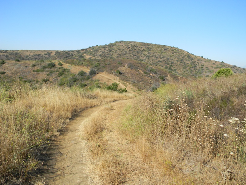
 The trail begins at the east end of the Discovery Center parking lot. You walk across the lot, towards a yellow gate. From there the trail continues as a dirt road for about 80 yards. There, it splits. The right branch becomes the Telegraph Canyon trail, which goes (duh) along the bottom of Telegraph Canyon, clear over to the park headquarters. The left branch climbs a sweeping arc along the north face of a hill, and is the North Ridge Trail.
As I climbed, I could look back at the parking area and Carbon Canyon Park, to the west. To the north, I saw several trails, though I'm not sure if they are "official" trails. Some of that area is part of Chino Hills ?State Park, while other parts are not. The Olinda Trail I mentioned in one of my linked posts above would have been just a bit to the west, within those northern hills.
 It took over a mile, I would estimate, before I got any good views over to the south, where I could overlook Telegraph Canyon. I also saw a huge development of some sort on the mesa on the opposite side of Telegraph Canyon that may be the water plant. Looks from the map that this is what is there, anyway.
The walk was kind of warm today, and I think warm weather is pretty typical this far inland. It was starting to cool, but it wasn't cool, yet. Given the steepness, it probably wouldn't be great for younger kids. They'd probably enjoy the Telegraph Canyon trail more.
[Wow, nice wi-fi here in the juror waiting room. My pictures uploaded way faster than with my useless DSL at home. For the amount I'm paying for DSL, I'm giving serious consideration to dumping that for wireless 4g wi-fi.]
Anyway, I turned around after about two miles and returned the way I came. Made it back to the car about 20 till 7pm.


No comments:
Post a Comment