 No, it's a time warp. I've gone back and written up a couple of hikes from much earlier in my quest. I'm not going to write them all up, because a lot of the earlier ones I largely duplicated later in the year. However, there are a few hikes that I have good shots I'd like share, or that I never repeated. Hike 20 was one of them. I hiked this back on February 12, 2010.
This one came about when the ranger at Mt. Baldy suggested it wasn't a good day to be hiking any of the high country trails. She pointed me towards Evey Canyon, which isn't quite inside the Angeles National Forest. Since it's outside the National Forest, you don't need an Adventure Pass to park there.
To get to the trailhead, you'd take the 210 freeway to Baseline. Exit Baseline, then briefly head west. After about 100 yards, you'll hit the light at Padua Avenue. Take Padua Avenue north about two miles, until you hit the next traffic light. That'll be Mount Baldy Road. Make a right there.
 Continue upcanyon about two miles. Be on the lookout for a gated road on your right. You'll reach it just before the intersection with a sign indicating a turn towards Upland. Yes, I know that doesn't seem to help. The point is that the parking area is just before you reach the national forest boundary, which is just after the intersection. The next time I'm in the area, I'll check on a mile marker. There's some shoulder parking available on either side of Mount Baldy Road, but don't block the gate.
 The gate indicates that the road ahead is private property, owned by Pomona College, of the Claremont Colleges. It also says entry is by permit, only. This does not appear to be enforced. Also, I tried contacting the Biology Department at Pomona for a permit (as the sign directed). My e-mails and phone calls (909-607-2993) were not returned. In any event, proceeding beyond that sign is at your own discretion. Since they never sent me the permit I asked for, I never went back.
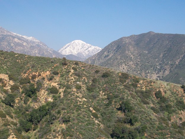 However, for that day last January, I did proceed. I figured if the ranger suggested it, I was probably pretty safe.
After crossing the gate, the trail continues to be a dirt road. Some portions had a nice oak canopy. Much of the way, a small stream paralleled the road. After at least a mile of what seemed pretty level travel (keep in mind it's been nearly a year since I hiked this), the road eventually started gaining some altitude. As it did, the view of snow-capped mountains, to the north, slowly improved.
 At the top, there's a concrete water tank. At the time this was one of the first of the kind I'd seen. After nearly a year of hiking, I've discovered these things are tucked all over the place. I guess they're where water is pre-positioned, in the event of a forest fire.
 From the water tank, you've got a pretty good panorama. You're well above Claremont, and can see both up into San Antonio Canyon to your north, and more distant mountains (probably San Gorgonio and San Bernardino) to the east and southeast.
Roundtrip mileage for this trail is given by Dan Simpson as 5 miles roundtrip, with a net 1,100 foot gain. In real-life, I think I cut that by a mile because I wasn't sure about the route. Since I hadn't seen Simpson's write-up at the time, all I had to go on is what someone I ran into on the hike said. I got the impression I was looking for a trail, so I took a trail that headed off from the road. Staying on the road is a wiser tact. There's only one turn you need to make, and it's pretty obvious (if your goal is to go up and not down). Simpson say's it's where a road marked as 1N04 starts back downhill (probably down towards Claremont Wilderness Park, although that's just speculation on my part).


No comments:
Post a Comment