Tuesday, October 23, 2012

Hike 2012.070 -- Barber Peak Loop, Mojave National Preserve

Hiked Sunday, October 14.

Saturday was our semi-annual Mojave National Preserve Conservancy star party. We had a clear, slightly cool, and windless night--pretty darn perfect conditions. I had moderate success with my relatively new Meade LX80 mount. I may post more about that in my sidewalk astronomy blog.

Sunday morning, I got a late start. I was debating on this. Usually, on the morning after our star party, I leave early, get my hike in, and miss the post-star party breakfast. That's so I can get back not too long after most every body has eaten breakfast, so my wife doesn't get stuck waiting by herself for long. But, on this day, I stayed for breakfast with our friends, which meant I didn't start my hike until about 10am.

Woke up much earlier than that, though. Enjoyed the sight of the morning light hitting Table Top Mountain (picture at the top of this post). I hiked that last April. Before breakfast, I also set up my solar telescope tandem for folks to get a peek at the sun before heading off for home. It was the same set up I used at Cedar City earlier in the year, and for the Venus Transit I watched from La Canada in June.

From the visitor center at Hole in the Wall, I hiked to and through the Hole in the Wall camp-ground. The Barber Peak Loop trail is probably a bit longer this way than if I had done it the right way, though it's the same way I did this hike the other time I walked it, almost two years ago.

At the north end of the camp-ground, there's a trailhead marker. The trail heads straight on north, then bends to the west, climbing towards the cliffs. It appears Barber Peak is a part of this mesa. Or perhaps it's the whole mesa. Unfortunately, I don't have a map that actually identifies the peak.

Most of the way from the camp-ground until after you've made it around to the north end of this mesa is a climb, although you do drop into a wash or two. You are rarely out of sight of a trail marker. Because of the crisscrossing old dirt roads, active dirt roads, use trails, cattle trails, deer trails, and who knows what else, the signage is helpful in keeping you on the right path.

Looking to the east, the sun cast layered shadows on the mesa walls in the distance. As I rounded towards the west, I looked east, and saw a back lit beaver tail cactus

Once on the north and heading down, you come across one of the larger "concrete" areas of the trail. It's a natural concrete--volcanic ash that became cemented, to the point where it really looks like someone just poured it out on to the hill. There are several other points along the way with concrete outcroppings.

The trail then heads west, then southwest. As you start heading southwest, you begin crossing what was once a dense pinyon pine-juniper forest. Regrettably, it, like the forest on Table Top Mountain, was burned a number of years ago. It actually looked a lot nicer now than it did two years ago, though.

As the trail heads to the south, you are frequently within sight of a dirt road. There's no pavement visible, though. And, in fact, if you just got dropped here, it might not be obvious how close you are to pavement. Between mesas, there's a definite sense of isolation.

Making my way to the south, I passed a pair of cows. I could swear these were the same cows I saw 18 months ago.

In addition to the dirt road and the several trails, there's also a dry river bed that runs along the way. Along this segment, I passed a couple of what could probably be considered "artifacts," though they were originally trash. Funny how NPS policy prohibits you from leaving new trash, but also prohibits you from taking old trash. ;D

Near the end of the southerly part of the trail, you pass near the Opalite Cliffs, an impressive outcropping of white and brown. They look clayish, though they could also be made of the same cemented ash that the other white outcroppings in the area are made of. I didn't immediately run across any quick on-line description of what they're made of.

From there, the path starts an easterly or southeasterly path. Before long, the trail makes a sharp left turn, up a hill. Had you gone forward, there would have been a substantial drop where the wash rushes down towards Wild Horse Road. I suspect this way is passable, but did not investigate carefully.

Instead, I stayed on the signed trail. It climbed (as I knew it would) up towards a gate. This incline is the start of a section of very thick cholla and barrel cactus growth. The portion of the trail immediately before here also had several burned skeletons of cholla.

This is the prettiest part of the hike, and probably what much of the last two miles would have looked like if not for the recent fire.

From the gate (intended to keep cattle on their designated allotment), it's mostly downhill towards Hole in the Wall. Expansive views to the south are also there to be enjoyed.

As the trail swings towards Hole in the Wall, I was again impressed by how impene-trable the wall appears. Yet, the trail heads straight in, and leads you up one of the chutes. Fallen boulders and metal rings provide the way through.

I thought the rock at the top of this cliff looked a little like a cross between George Washington and Abraham Lincoln.

Also in this little slot canyon segment, I saw a whiptail lizard. It wasn't the first lizard I saw this day, but it was the only one that stuck around to be photographed.

By the time I was inside this slot canyon and heading up the rings, I was tired and ready to go home. Didn't take any pictures after the lizard. Shoulda worn a hat. Pictures of that section of trail are in my previous blog of this hike, linked above, and here.

Now on the top of the slot canyon, I passed a sign indicating a possible ring-assisted path to a viewpoint atop this canyon. Not sure--didn't head that way last time, either. Maybe next time, I'll take a short little 3-miler, just around the visitor center, and include a scramble up these nearby rocks, just to see what's closest to the start.

Thursday, October 18, 2012

I hiked on Sunday

Took a hike on Sunday (not Saturday, as I originally posted). But it's starting to look like I'll take over a week to get the post done. That was Barber Peak, by the way. I did that one two years ago. It was a nice hike.

Barber Peak is in Mojave National Preserve. I was there again for our semi-annual Mojave National Preserve Conservancy star party. Arrived on Friday afternoon, and was met by the first of many tarantulas. Apparently, it's tarantula migration season.

Plenty of time to set up the tent, set up the telescope, and eat dinner.

Gave my LX-80 mount a pretty good work out. I'm going to have to write a short review on that mount one of these days (on my sidewalk astronomy blog, of course). That's it, supporting my C11, as we're all sitting around waiting for dark.

I was sick before Mojave, and sick after. Still not at 100 percent, and I get chilled quickly.

Haven't managed any hikes since then. Probably won't be able to manage a hike before Sunday, at the earliest. And that's pretty iffy, too. Something short on Monday is more likely. But I should manage to get my hike blog updated by then!

Monday, October 8, 2012

Hike 2012.069A -- Bee Rock, Griffith Park


Hiked Saturday, October 6.  Another post-work hike.  I didn't make it to the trailhead until around 5:30pm.  Things were kind of weird when I arrived, because there's a haunted hayride thing going on in this area of the park.  There was also some sort of Christmas thing going on down the trail, so I'm a little confused about what that's all about. [edit--I later found out the Christmas thing was part of the haunted hay ride--go figure!].

I started from the parking lot near the Merry-Go-Round.  I'm not sure if I got to the actual lot considered the "Merry-Go-Round lot," because there were cones set up and people directing traffic for folks trying to get to the aforementioned haunted hayride (I wonder if "aforementioned" is the longest word I've ever used on this blog?).


I think this was the southern end of the lot.  There was a gate across the road that was heading to the west, but I think that was so employees could park there--there were plenty of cars parked beyond the barricade.  However, I turned right at the gate, and asked the guy directing traffic were I should park if I was just here to hike.  He said I could park in the lot I was in.


From there, I walked past the barricade.  I also passed a trail with a "4" on it as I headed west.  Joining a wide, dirt road, I passed one trail heading north and took the second right.  I'm pretty sure this is where an "8" would be if the Old Zoo Trail were properly signed.

The trail headed north from there, climbing as it went.  It did not take long before I saw a rock outcropping that I deduced must be "Bee Rock."  I could also see a chain link fence atop the rock.

Meanwhile, as I climbed, below and to my right was music that I assumed was part of the Haunted Hayride.  However, the music made me imagine an 18" tall letter "Pi" descending on a stage!

Even odder was later on the hike, when I heard what sounded like elves singing "Santa Claus is Coming to Town."  That was by what looked like a Santa's Village sort of set up, with fake snow, snowflakes, snowmen, and a city general services truck.  It was the oddest juxtaposition of sights and sounds I have ever encountered on a hike (Is "juxtaposition" longer than "aforementioned"?).


The Santa's Village thing was where a trail cut across the Zoo Trail, and headed down to the old zoo.  Shortly after crossing that junction, the trail to Bee Rock was off and to the left.  It begins as a continuation of a dirt road, but rather abruptly, at a turn, becomes single-track.  Switchbacks take you through, around, and under some thicker vegetation.  In several spots, steps had been cut into the trail, which now ran adjacent to rather than over the steps.


Finally, I attained the altitude of Bee Rock.  From there, it was a sharp turn to the left, then along a trail, then hopping atop the rocky top of the outcropping.

It's a shame somebody felt the need to put a chain link fence around the summit.

I took many pictures from there, and enjoyed the view over the city scape.

On my return trip, I took the short detour, bypassing the trail back down and continuing briefly to the west.  I climbed a short set of stone steps and arrived on the aging pavement of Vista del Valle Drive.  I had seen this road a few days earlier, when I hiked Hogback.  I contemplated if I had time to take Vista del Valle to the north, where I could then take the Eckert Trail back and around to where I started.  However, it was 6:30pm by now, so the answer was, "No."


Instead, I returned the way I came.

I'm not sure on the mileage.  Several sources give a 2.2 mile distance for the loop that includes the Old Zoo. However, I think the trail though the Old Zoo (labeled PaDTL Trail on my photocopied trail map, and indicated as a paved road on the LaBonge map), looks to be somewhat shorter than the Old Zoo Trail I took both ways.  However, it doesn't look 3/4 of a mile shorter.  Also, it took just over 30 minutes on the downhill return from Vista del Valle Drive.  That makes it unlikely that I actually covered 3 miles that day, so I guess I can't count this as an official hike towards my target of 100 for the year.

The other thing that disappoints me is the discovery that, barely in October, it's already too late to fit much of a hike in after a shift that ends at 5pm.  Before long, after DST ends, they may not even fit in after a 3:30pm shift end.  Unless I start taking more weekends off, I think making my hiking goal this year may be problematic.

I think Blogspot has changed its formatting a bit in the past few days, so I can't get the same layout I normally use. Sorry about that.

Sunday, October 7, 2012

Hike 2012.069 -- Turnbull Canyon and Sumac Trails

Hiked Friday, October 5. As an otherwise hikeless week drew to a close, I finished my regular day job's work week, and figured I had just enough time for a short hike in the Puente Hills Landfill Native Habitat Authority's territory.

The trailhead I took is off of Turnbull Canyon Road. Turnbull Canyon Road is what Beverly Blvd turns into just east of Whittier (the city). The Turnbull Canyon Trail is labled "Rose Hills No. 3 Fire Road" on Google Maps. There's an informational bulletin board/kiosk at the trailhead, but no developed parking spot. You just look for a wide spot adjacent to the road as you approach the trailhead. It's right after the curbing disappears. The trail will be on your left.

As I approached the kiosk, I passed a paper sign that noted this trail was closed from Monday, Oct 1, through 4pm on Friday, October 5. I checked my watch and saw it was 4pm, so bully for me. I'm not sure if the closure was related to the Tehatchapi Renewable Project, or to habitat restoration along this trail.

As implied above, this trail begins as a dirt road wide and dusty. A seasonal creek bottom is on your right, and you parallel that creek for 7/10ths of a mile. Serious habitat restoration is also going on, which has left lots of tree stumps and barren ground where invasive non-native plants had been removed. They also had some barriers hammered in around the creek bed.

On your left, several signs admonish you to stay on the trail and out of the habitat restoration area. The hill was mostly covered with dry annual grasses. They provided a nice contrast to the blue sky and white clouds that stretched above.

Before long, you can look up the canyon. A bit to your left, you can see a water tank in the distance. That was my destination for today.

After about 2/3 of a mile, a side canyon comes in from the left (northwest). At 7/10ths of a mile, the Turnbull Canyon trail crosses the creek and continues, easterly. However, I instead continued straight, along what is the Sumac Trail. The dirt road soon gives way to the remains of a paved road as you climb out of the canyon and towards Rattlesnake Ridge.

As you ascend, there are nice views down into Turnbull Canyon, and over the urban basin to your south.

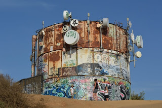
After 6/10ths of a mile, you reach another fork. To the left is Rattlesnake Ridge, which puts you across a canyon from Rose Hills Cemetery. To the right (the way I went), you turn a corner, then encounter a steep, ridge-running trail that heads towards a rusted and graffitied water tank.

I'd estimate it's about 1/3 of a mile to the watertank, which makes the entire one-way distance between 1.6 and 1.7 miles. Roundtrip distance is thus about 3 1/3 miles.

On the way back down, I explored a short distance along a trail that headed to the northeast. It seemed it might connect to another trail that would provide an alternate, shallower climb to the water tank. However, without going further than I had time, it did not seem to do so.

I took a shot of the Asian pagoda in Rose Hills, which I have photographed in the past, then returned on the path I came. The whole hike took about 90 minutes.


Tuesday, October 2, 2012

Hike 2012.068 -- East Ridge (Hogback) Trail, Griffith Park

Hiked Sunday, September 30. Another post-work hike. I started around 5:15pm, though the temperatures were still very high and dry.

From the Observatory, I elected to head down East Observatory Road. That's where employees park, and the route that is suggested for hikers and bikers coming up or down along the road between Vermont and the Observatory. Of course, this doesn't stop slightly insane people from walking or biking through the narrow tunnel that leads to West Observatory Road, but there's no way I'd walk through that tunnel if I didn't have to.

If traffic, time, or your own inclina-tions prevent you from parking up near the Observatory lot, you could start this lot down on Vermont, just north of, and across the street from, the Greek Theater. (edit 2/2/2019 -- Also, now that you need to pay for parking at the Observatory, parking down below, where it's free, makes even more sense). Roundtrip mileage and net altitude gain would be the same.

From the top, it's just about one mile of walking along the road (edit, 2/2/2019 -- There's sidewalk along most of this section of road, now, and I think the rest will get sidewalk in the next month or so). First, you head down and to the north-northeast. When you reach Vermont, you make a sharp right. That road loops up to the mouth of Vermont Canyon before sweeping to the south. Just north of the Greek Theater, a path heads east, into the hills.

It's a brisk climb that soon rewards you with a view on to the seats of the Greek (the stage faces away from you, of course). As you reach a crest, tennis courts that are just north of Commonwealth Avenue, and the Roosevelt golf course are to your south. If the skies are clear, you've got a wonderful view of the downtown Los Angeles skyscrapers for nearly the entire length of this trail.

This trail is labeled "Riverside Trail," although no river was apparent to me. You do approach a canyon bottom. A trail crosses your way here, heading both south, towards the tennis courts, and north, into the canyon. It seems to be one of three ways to get up to the Hogback Ridge.

Even from down here, you can occasionally see people making their way along the Hogsback, far above.

Meanwhile, your hike still has miles to go before you sleep.

Your path now heads back towards Commonwealth, before turning east just before reaching the street. Trail access would be possible from here, though I'm not sure about the parking situation on Commonwealth.

I noticed a large number of "cedar" here. Some were burned, and most looked ragged and aged. There's no doubt that this locale is drier than their native habitat.

About 1.25 mile from Vermont, the trail rises to what looks like some sort of utility housing. Not far ahead is a mostly-paved road (no public car access, though plenty of hikers). Meanwhile, about a 270 degree turn to your left puts you on the East Ridge (Hogback) trail.

This trail takes you higher, and gives you a return view of the Observatory (my first from the east). After a turn to the north, most of the rest of the Hogback is now visible to you. Yeah, it looks steep, and it is.

There's also a small metal bridge ahead, which crosses a ravine.

Just before crossing the bridge, "Henry's Trail" is on your right. It's a short, roughly 1/5th of a mile trail to the top of Glendale Peak. The first 20 yards or so are steep, up eroded dirt steps.

A small snake, only a foot or so long and 1/2 inch in diameter, somehow found itself among these steps as I headed up the trail. It tried to get out of my way quickly, but the steepness and dusty sand made that impossible. Once it determined no quick getaway was possible, it adopted the opposite tack--it stopped, then slowly slid its way off the path.

I continued to the "summit," where a concrete-embedded surveyor's monument has seen about a foot of erosion come off the top. As with much of this hike, there are nice views from there towards downtown Los Angeles and Downtown Glendale.

By the time I was finished taking in the view (and a few phone calls--another story), the sun was nearly setting. I returned to the East Ridge Trail, crossed the bridge, and headed up towards Mt. Hollywood.

I soon discovered that this segment was longer than it appeared. It looks to be very nearly 1 mile from Glendale Peak to Dante's View.

Once there, I determin-ed there was no need to actually head up Mt. Hollywood, again. So I continued from Dante's View to the west, taking the Charlie Turner trail back to the Observatory.

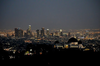
Along the way, I stopped at the turn where I observed the shuttle flyby just over a week before. Tried taking some skyline at night shots. I had no tripod, so I just set the camera on my backpack, and tried both shooting regularly and using the self-timer. In theory, the self-timer would allow for picture taking without the risk of my hand triggering the shutter inducing vibrations. On the other hand, just tripping the shutter of a camera on a backpack probably induces some vibrations.

Not entirely pleased with any of the shots, though I'm not sure if my future efforts at getting this shot will be any better. Perhaps I'll switch to full manual to try to expose more for the lighted areas, and reduced the noise you get from long exposures at high ISO.

After about 20 minutes of trying for that skyline shot, I continued down the trail. It was now fully dark. The Harvest Moon was supposed to be rising, but a ridge would block my view of the moon until I was quite near the end of my hike.

Once in the parking lot, I tried a few shots of the moon. The first were heavily overexposed, as expected. Auto-exposure cameras try to balance the light with the dark, and that means a picture that is well-exposed "on average" results in a black sky and a completely washed out moon.

After a few of those shots, I switched to manual. I also needed to figure out how to make adjustments. It would appear that I could set camera to "A" (aperture-priority), use the dial on the back of the camera to dial in my desired lens aperture, then switch to "M" (manual), and use that same dial to set the shutter speed.

I eventually determined that, at ISO 400, f 5.6 and 1/400th of a second worked pretty well.

The results are still not super-sharp. But the ISO is 400, and I'm not sure how precise the autofocus is (or if I could have done better in manual focus mode). The picture looks okay at snap-shot size, but I can't blow it up much more than this without the edges getting ragged and the sharpness getting worse.

I'll have to try again when the moon's a crescent. I think then, the shadows would give the camera something more distinct to focus on. I can also try some manual focus shots. I may also have to think about getting a t-adapter, so I can try to take some shots through one or more of my telescopes. I don't want to get serious into astrophotography, but maybe a few moon pictures, and maybe some Milky Way shots, with high ISO and exposures of about 30 seconds.

I'll call it 4.5 miles for the day. Felt good to stretch my legs, which I hadn't been able to do in over a week. I've fallen a bit behind on my target of ten hikes per month, but the unofficial goal of 100 hikes for the year is still attainable.