 Hiked Barber Peak loop on Sunday, October 31. Six miles. Hiked the Rings loop on Saturday, October 30. One mile.
The Hole in the Wall (HITW) Visitor Center is located near the end of the pavement of Black Rock Canyon. From Barstow, you head east on I-40 for about 100 miles. About 50 miles past Ludlow is a well-signed exit for Providence Mountains State Park, Mitchell Caverns, and Mojave National Preserve. Don't jump the gun and inadvertently get off one exit early, at Kelbaker Road, which is also signed for the Mojave National Preserve.
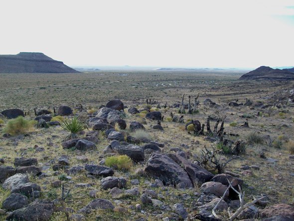 Exit I-40 at Essex Road and head north. After about 10 miles (roughly), Black Canyon Road (the only paved turn off of Essex Road) is on your right. Continue an additional 10 miles or so. When a large cattle grate crosses the road, slow down. A left turn immediately after the grate leads you to HITW visitor center and campground. Turning right immediately after the grate leads to Black Canyon Equestrian and Group Campground. The shot above, taken from 1/2 mile or so north of Hole in the Wall campground on the Barber Peak Trail, shows the HITW campground above right-center, and the Equestrian center across the wide dirt road, further off and to the left.
Over the past few years, the Mojave National Preserve Conservancy and/or the NPS have sponsored annual star parties around the anniversary (October 31, 1994) of the Preserve's creation. More recently, the conservancy has added a spring star party.
 These are low-key affairs, not like the supersized star parties that may attract hundreds of amateurs astronomers and their telescopes. In Mojave, we've never had more than about five telescopes there, for the 50-200 friends of the preserve that come to these parties to enjoy the dark skies of the Mojave Desert.
 What makes Black Canyon so great for these star parties (besides the dark skies) is that there's a small concrete pad, adjacent to a large pavilion. Partiers can enjoy their food and refreshments on in the pavilion, while telescopes can be set up just fifty yards away or so, in relative darkness. Even a roaring fire in the pit just below and south of the pavilion is essentially invisible to the telescope observers just above and north of the picnic tables.
However, if you're not coming for one of the big group events (and you almost certainly will not), Hole in the Wall is a very nice campground just on the other side of Black Canyon Road. The www.nps.gov/moja website says there are 35 campsites at HITW, and are available first-come, first-served only for $12/night.
 The Rings and Barber Peak trails both begin at HITW.
The Rings trail has one trailhead that begins at the southeast end of the small lot adjacent to the visitor center. The trail ends at a small picnic area just a few hundred yards northwest of the visitor center. They give the distance as 1 mile roundtrip.
 Starting at either end requires a short walk along the connecting dirt road. If you do the hike in clockwise fashion, you start at the visitor center lot and walk past a large informational sign. The trail parallels the dirt road you just took to get to the visitor center for a while. The varnished rocks to your right have historic pictographs and more recent graffiti.
 The trail then parallels Black Canyon Road for a while, then parallels Wild Horse Canyon Road. Finally, it bends to the northwest, apparently running right into an impenetrable rock wall. However, as you approach the rock, the wall parts. You walk up a slot canyon that narrows and becomes steeper. You also see that the walls are pockmarked by erosion holes--Hence the name, "Hole in the Wall."
The last 1/8 requires pulling yourself up two short (ten feet or so) segments via metal rings that have been attached to the rock face. After the second climb, two alternatives present yourself: Head right or head straight. Either takes you out of the slot canyon and deposits you at the small parking area for the HITW picnic area. A pit toilet and water is usually available here. However, here and in the camping areas, the water generally needs to be trucked, so do not be wasteful.
 If you were to do this trail counterclockwise rather than clockwise, you'd have started at the picnic area and used the rings to lower yourself down the slot. Personally, I find climbing up easier than going down (because my eyes are in my head and not my butt), so I went clockwise. I suppose no matter which way you go, you shouldn't attempt this if you can't suspend your weight with your arms.
 The next morning (after a pretty cold night of astronomy outreach), I attacked the Barber Peak loop. Parking at the picnic area, I somehow did not see the start of the Barber Peak trail from that parking lot. Instead, I wound up on the trail that led me to the entrance to the HITW campground. From there, I headed north on the dirt roads to the end of the campground, where a small sign and empty glass display marked another trailhead to the Barber Peak loop.
On this trail (as with the Rings), you'll come across plenty of cowpies. The Mojave Preserve has lots of open range. It seems weird because on much of the Preserve, there just isn't very much greenery for a cow to eat. Nonetheless, I guess the grazing fee is so low that it makes up for needing to manage your herd over spectacularly large swaths of federal lands.
 As you make your way along the trail, you'll cross through several barbed wire fences. At each crossing, there's either a latching gate or a little zig-zag that a person can easily navigate but a cow can not. It's supposed to keep cows in specific grazing areas. The grates that cut across the highway are supposed to do the same thing. This means you need to take some care when driving that you don't literally run into a cow. They're big, so hitting one with a car would be bad for both you and the cow.
 When on the trail, it's the weirdest experience when you approach a cow. They just stare at you, from hundreds of yards away. Their eyes follow you for several minutes as you approach. Fortunately for me, as I got closer, they eventually headed the other way. I'd hate to get trampled by an angry cow.
My path on Sunday was a long counterclockwise loop around the mesa that is Barber Peak. The scenery is nice, but evidence of a 2005 fire is everywhere. Skeletons of Joshua Trees, pinyon pine and juniper are all over. Dead Joshua trees dominate the start of the hike. As your path begins to curve to the west, dead pinyon pines begin to dominate. Later, it's juniper. Then, as you make your way back to the south, the fire damage is less evident and cholla and barrel cactus and yucca become to predominate.
 It's actually very sad to see all those dead pinyon pine on the north slope of Barber Peak. You just imagine the wildlife that relied on those pine nuts and wonder how many years it will take before that forest of pinyon pines returns, or if it will ever return.
 Several sandy washes run off from Barber and other peaks, so the NPS has marked the trail with numerous plastic sign stakes that are supposed to keep you on the trial and from inadvertently wandering up or down a wash or jeep trail. About halfway through the trip, however, your trail becomes a jeep trail. Finally, you pass a "No Motor Vehicle" sign, and your trail is again a trail. It climbs a short but steep incline, at the top of which is. . . A gate. On the otherside of the gate is an expansive view to the south and west. And lots of grass and cactus.
 Finally, the trail loops to the east, to the mouth of Banshee Canyon. From there, you can either head up Banshee Canyon (which is where the Rings are) and up to the HITW picnic area lot, or back down the loop to the visitor center lot.


Great write-up, and I must have been on the trail just a couple hours after you.
ReplyDeleteThanks so much for bringing the stars to our star party!
Hey, Chris!
ReplyDeleteI was the guy cleaning out tent and packing his car in front of the pavilion while you were talking to a couple of other folks there. I started packing right after I got back from my hike on Sunday morning. Left camp around 7:30am and got back a little before 10:30am. I took a boatload of pictures (over 200 on my two little hikes), so that slowed me down by quite a bit. :D
Always happy to do astronomy outreach, including at the Mojave National Preserve. It's a long drive, but a good location to do it. Didn't have time this year to work on a longer observing plan, so I just showed some of the brighter, easier objects that I could find without computer assistance.
Likely be there again in the spring, so see you then.