Hiked Friday, July 17. Even before the most recent rains in southern California, I was surprised to find that water still flowed in lower Icehouse Canyon. I had somewhat ambitious plans at the start of my day, but got lazy and wound up walking only to the wilderness area boundary. 3.6 miles from the trailhead, roundtrip. Maybe another one or two tenths of a mile if you're parked at the bottom of the parking lot, and if you take a number of detours into the creek area to get some water pictures. I'm rounding up to four miles for no particular reason.
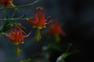
There is perennial water in the canyon, but usually it's just a small seep, between one and one and a half miles up the trail, where water comes in from the left, and maintains a health stand of columbine. So I guess my main goal on this hike was going to be the columbine. That's just the mood I was in. It's only when I saw the water in the creek that I started shooting a lot of creek pictures.
I was starting too late, however, and there was a pretty harsh light and a lot of contrast between the sunny and shady areas. My photos of the water and of the water near a cabin were generally pretty disappointing.
Meanwhile, the area with the columbine was mostly shaded, and, in many cases, left the flowers in dark shade, or under alternating dark shade and bright shafts of sunlight. Very hard to photograph under those conditions.
This was hike 55 of my now-58 hikes of the year. Short hike, but long enough to count as a hike, and a nice add to my daily step count. Add a night shift at the Observatory, and I was well over 20,000 steps for the day.
A Cold Morning on Chloride Cliffs | Funerals #3
-
I inched toward the edge of the cliff under cover of darkness. My
super-bright, bumper-mounted Diode Dynamics SS5 lights cut multi-mile-long
daggers into t...
2 days ago


