I recently (closely) reviewed the new (mid-March) Bobcat Fire closure order, and discovered that San Gabriel Peak and Mount Lowe were now outside the closure area, as was most of the Old Mount Wilson Toll Road, and most of the old Mount Wilson Trail (but not the uppermost section, and not entry into the Winter Creek drainage). So, immediately after work, off I went.
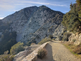
Recent trips up here had been via the trailhead near Red Box Junction. In particular, I started from there to get a nice view of Comet Neowise, last summer. But I have hiked from Eaton Saddle numerous times, as well. Can't find any of my blogged hikes, at the moment, however! You reach Eaton Saddle by taking Mount Wilson/Red Box Road, up from Angeles Crest Highway and Red Box Junction, towards Mount Wilson. When you first see sky in front of you, you're at Eaton Saddle. The actual road makes a left, here, and heads east, to Mount Wilson. But there is a small parking area at the saddle, on the right side of the road. The dirt road is gated to motorized vehicles, but obvioulsy hikers, bikers, or horses can proceed. After a short 1/4 mile or so, the trail goes through a World War II-era tunnel. The road is dirt, with a fair amount of rocky debris fallen over it, in places. Easy hike, but you do need to watch for rocks, so you don't kick or trip on them.Rather impressive drop-offs adjacent to this road.
Another 1/3 of a mile or so after the tunnel, you reach another saddle. San Gabriel Peak is to your right (it was right in front of you when you started on this trail, as well). Mount Markham is to your left. Mount Lowe is not visible, but is further, past Mount Markham. Straight ahead on the road would take you down to Lowe Camp. Since I wasn't sure about how much daylight I had, I decided to do the longer peak hike, first. So left, up towards Mount Lowe. Site tubes are at the top, pointing out the various peaks visible from the promentory. There are also some swings.I only stayed briefly, then headed back down, hoping to bag another peak.
There were a pair of hikers at the top of Mount Lowe when I got there. They left shortly thereafter, but I caught up to them by the time we got to the ridge of Mount Markham. Had they continued down towards Eaton Saddle, I likely would have tried bagging Mount Markham. But since they stepped aside and paused there, I continued towards Eaton Saddle.
Once there, I deduced I did have time to bag San Gabriel Peak. Headed up there, where I encountered three hikers and one baby in a carrier. Those were the only other hikers I saw on this day. I wore a mask, as is my nature, even though I was well-past two weeks after my second Pfizer dose. Figured the people I might run in to wouldn't know that, and I figured it is still the responsible thing to do. After all, 95% immunity is not 100% immunity. Again, stayed only briefly before heading down. The sun set just before I reached the summit, so I knew it would be pretty dark by the time I got back to my car. But it's a wide trail (albeit, with the substantial dropoff, previously noted), and I had my phone for light, if I needed it. I did, but only when passing through the tunnel. Otherwise, city lights always do a satisfactory job of lighting the way, if you've got a clear view towards the city. Got a decent shot of the Big Dipper, just before I got in my car to drive home. About 5.6 miles, and 1,500 feet of gross elevation gain, according to Alltrails. Either peak is a pretty easy, post-work hike in the spring. Fitting both in requires a bit more time, or a bit more daylight.


No comments:
Post a Comment