 Hiked Saturday, July 7. I took a long loop through the heart of Topanga State Park on Saturday: from Trippet Ranch, east and south on the Santa Ynez Canyon Trail, up and back to near the waterfall, then along Vereda Montura and Michael Lane, then north and east on Trailer Canyon Fire Road, then north on Temescal Ridge Trail, then west on Eagle Rock and Eagle Springs Fire Road, back to Trippet Ranch. Total mileage for the day would be approximately 11 miles; gross altitude gain would be about 1200 feet (net zero altitude change, of course).
 I made another visit to Woodland Hills Camera and Telescope. To help justify the mileage, I combined it with another hiking trip. Saturday, I visited Topanga State Park. From the Ventura Freeway (U.S. 101), about 8 miles west of the San Diego Freeway (I-405), exit at Topanga Canyon Blvd (CA-27) and head south.
 The first major inter-section is Ventura Blvd. There's a Ralph's, Rite Aid, Chipotle Grill, Subway, Starbuck's, and assorted other shops on the northeast corner of Ventura and Topanga Canyon, in case you need to stock up on provisions. Just south of that corner, on the the east side of Topanga, is Woodland Hills Camera, where I was visiting. About two blocks south of that is a another Starbuck's, also on the east side of the street. Unfortunately, there really aren't any conveniently accessible food places on the west side of the road.
 After about 1 mile and a half, Topanga begins its climb up into the mountains. It's mostly one-lane from here.
A total of 8 miles south of U.S. 101 (just after mile marker 4.8--and note that the miles will decrease as you head south, reaching zero at the Pacific Coast Highway), you'll find Entrada Road, on your left. There's a sign announcing the approach of this entrance to Topanga State Park just before that turn, but there is no left-turn pocket to pull into, so you might want to turn your blinker on early and slow down as you round the turn, so the traffic behind you doesn't rear-end you.
 You'll now be on an even narrower, windier road than the one you were on. After three miles, you reach the entrance to Topanga State Park. There's a ten dollar entry fee, though if you've joined the California State Parks Foundation, you can use one of your coupons to enter the park for free.
 Alternatively, you can park with all four wheels completely outside the white limit line of Entrada Road somewhere outside the entrance station. It seems the vast majority of area visitors choose this option, though, since I had my coupons, I handed my little pass to the ranger at the gate and chatted with her for a few moments before pulling in to the more-than adequate parking lot.
Flush toilets, drinking fountains, and picnic tables are around the parking area. There's also a nature center, though I did not visit it.
 The main trailhead is on the southeast end of the lot (that's a "by feel" direction; I didn't use a compass). That trail heads up the hill, and provides access to trails to Eagle Rock, Parker Mesa Overlook, and Santa Ynez Canyon. This trailhead would also get you on the east-bound Backbone Trail, clear over to Will Rogers State Historic Park.
The trail head on the northeast end of the lot could take you to Musch Camp or Dead Horse Trail. Dead Horse trail or Entrada Road itself seem to be official access points to the westbound Backbone Trail.
Once in the parking lot, I studied the map I just bought, as well as the Tom Harrison map of Topanga State Park, which I puchased during my visit to King Gillette Ranch, the headquarters/visitor center for Santa Monica Mountains National Recreation Area.
 Both on the map and at the first trail signpost I saw, were the words, "Waterfall." I did not expect much, given the dry year and July date, but figured that was someplace worth checking out. So my initial plan was to hike down up to the crest, then take the Santa Ynez Trail to the waterfall. Then I though maybe I'd walk back up to the crest, then maybe take the trail to Parker Mesa Overlook.
However, I hate backtracking, so I ended up doing something different.
From the crest, I could see a thick bank of fog. I knew the ocean was beneath that, but could not see it.
 After clearing the crest, it's mostly down hill, dropping in some areas quicker than others. Several trails that did not appear on my map were also passed. Eventually, however, I reached a marked junction, with an arrow pointing to "Waterfall." That was right about where I ran into six people with nets. No, not from the looney bin--hunting for butterflies.
From the sign, the trail drops into a dry stream bed (probably not dry in the early spring). The trail went both upstream and downstream from here. I assumed that my waterfall would be upstream, so I headed that way. Shortly, I passed a guy with a radio controlled Hummer. He was driving it up the dry stream bed. Yes, our state parks are used by all sorts for all sorts of recreation.
The trail crossed from one bank to the other several times. I felt like I headed up this way at lest 1/2 mile, perhaps 3/4 of a mile.
 I came across a very thick growth of Humboldt lilies. That was cool. Previously, I had only seen them growing singlely, but here they grew 10-12 feet tall, and with a dozen blooms or more on each plant. Reeds were also here.
About 1/4 mile after this spot, I came to a spot where the trail seemed to climb unreasonably steeply up one of the banks. I decided that must be the end of the trail, so I dropped back down into the stream bed, and worked my way up another 100 yards or so, to a point where a couple of large boulders seemed to block the way. There was a small, 8-foot or so drop here, and water trickled down.
I walked to the barricade and peeked over. The boulders were on top of a sandstone base, which was weak, and made slick by the rushing water over the years. I tried a few footholds and hand holds. After a moment, I concluded that I could likely climb up this barrier safely, but I was also pretty sure that any attempt to climb back down would lead to a slip and a splash into the pool of water at the base.
 I thought this was the actual waterfall. Seeing no obvious way around this barrier than going right over, and not seeing any evidence of a larger waterfall just beyond, I concluded (incorrectly) that this must be the waterfall.
I snapped a number of pictures, while a group of college-aged kids came up (they had earlier tried a route around this barrier, and turned around).
The taller of the two boys tried a few foot holds, then slipped into the pool. Uninjured, but wet.
He eventually did make it up to over the barrier, but I became even more convinced that going beyond this barrier would probably not end well.
While the kids were still poking around the barrier and deciding what to do, I returned back to the trail junction, then studied my map.
 I saw that if I continued down this trail (rather than turning back up the Santa Ynez trail I had taken to get here), I would soon pop out on a street. About 1/2 mile northeast of where this trail popped out, another trail (the Trailer Canyon trail) entered Topanga Park. Since I hate backtracking, I decided on this alternate (much longer) return route.
Coming out to the street, the exit of this trail was a set of stairs that passed between a wrought iron fence. In front of me and to my right as I reached the sidewalk, gates blocked access to the street.
I pulled out my map again, oriented to north, and figured out where my trail access would be. Determined it was to my left, and headed that way. I soon passed a street sign that confirmed that this was Vereda de Montura. Reached Michael Lane and made a left.
 Recently-painted condominiums lined this street: bright white paint and red tile roofs. The road climbed and north, then east. Eventually, the condos gave way to single-family homes. There were wide sidewalks on either side of the road, so the walk was an easy one.
Finally, seemingly further than the map would suggest, I passed a sign for Trailer Canyon fire road/trail. The sign was pretty much obscured by tree growth, and if I were driving, I doubt I would have seen it. But I was walking, so it was easy.
 Just east of that sign was what might seem to be a private driveway. Whether private or public, I don't know. But the trail right of way clearly went up this road. 75 yards from the street, at the end of the concrete, was a gate. Beyond the gate was a sign announcing this was Trailer Canyon.
Just pass the gate was a trailhead sign, with numerous mileage given. It claimed it was 6.6 miles from here to Trippet Ranch. However, if you add up the distance of the various segments between here and there, it would be about 1/5 of a mile longer than that. Either way, it was starting to feel like a long way back.
 At this point, I would have traveled about four miles, already (2.2 from Trippet Ranch to the end of the Santa Ynez Trail, about 1/2 mile from that trail end to the start of the Trailer Canyon Trail, and the 1.5 miles or so roundtrip from the Santa Ynez Trail to the "waterfall" and back.
Still didn't want to backtrack, though, so I pushed on.
About 3/4 of a mile later, I passed an open gate that was the boundary to Topanga State Park. Also there was a sign advising "No Fires" and "No Dogs."
Almost immediately after that sign, a jogger came down the trail, with his unleashed pit bull not far behind.
 After 2.2 miles total, the Trailer Canyon Fire Road intersects with the Temescal Ridge Trail (another fire road).
1.4 miles later, the Temescal Ridge trail is met by what is labeled the Rogers Road Trail on my Topanga State Park map, and as the Backbone Trail on my Tom Harrison map. I don't recall what the signage on the ground called it, but I do recall it gave a distance to Will Rogers State Historic Park, so I knew which trail junction I was at.
 A false trail continues on the opposite side of the Temescal Ridge trail from where the Rogers Trail comes in. The actual Temescal Ridge trail is the narrower of the paths leaving this junction, heading somewhat to the north-northeast from there.
Shortly after this junction, there are the first of several expansive views to the north and east (more such views are possible shortly after Hub Junction, too). Nearby, the towers of Century City were the closest cluster of skyscrapers. Farther in the haze and further to the north was downtown Los Angeles. Beyond and just south of Century City, near the horizon, the Santa Ana mountains peeked above the haze.
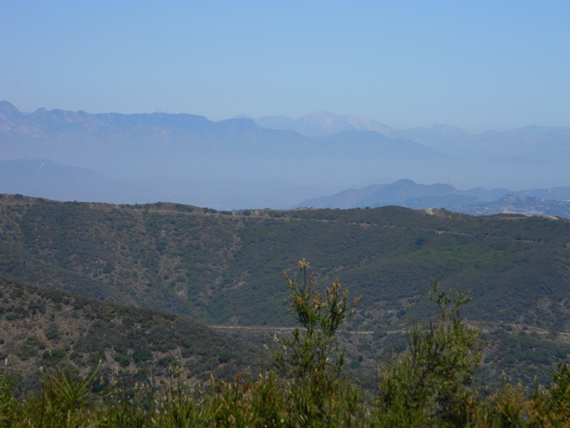 When the views opened to the northeast, I could easily see the San Gabriel Mountains. The white domes of the big telescopes on Mount Wilson stood out as tiny specks. To its left were the radio and television transmission towers. Further left was San Gabriel Peak.
Far right of all of this was Mt. Baldy (Mt. San Antonio). The exposed dirt of the peak looked almost like snow in the distance.
 Later, views back to the south and southwest were also looking somewhat wilderness-like. The flora was thick and the hills rolled far into the distance.
At Hub Junction (.7 miles past the junction with the Rogers Trail), a back hoe and an informational kiosk appeared to be in the midst of a project. There was also a portapotty and several trash cans here. I don't know if that's a normal feature of this location, or if the portapotty is only there until the construction project is done.
 Four trails meet here, and the trees near this junction provided a bit of shade (which had been pretty rare since leaving the Santa Ynez Trail).
In addition to the trail I just arrived on, there were two heading towards Eagle Junction. The lower one would go pass Eagle Springs. The upper one would go by Eagle Rock. Both were 1.3 miles to the junction.
Given the indifference of distance, I elected to take the high road because I thought it might have a better breeze. I was pretty hot by now.
 The fourth trail headed to the north, and is listed on the both of my maps as "Fire Road 30." That would take me to the unpaved Mulholland Road, as well as several Santa Monica Mountains Conservancy holdings. Since I was trying to get back to my car, this road did not interest me that day.
 The high trail to Eagle Junction begins with a winding climb that deposits you near a bench, just a hundred yards or so from the junction. From there, you spend the next 8/10ths of a mile near the ridgeline, with many impressive views but little shade.
 Eventually, Eagle Rock appears below you.
It's a large rock, but looks nothing like an eagle to me. Also, because it's lower than the path I was walking on my approach, I didn't have any real interest in taking even the short detour it would take to summit the rock. I was satisfied with taking many photos of the rock.
 This whole approach reminded me some of either Half Dome versus Cloud's Rest (Yosemite National Park), or Angel's Landing versus Observation Point (Zion National Park)--Everyone wants to summit the iconic point, but if you're on the iconic point, you can't *see* the iconic point. This could just be me being contrary, however.
 From Eagle Rock, the trail still descended somewhat steeply in points, and I still had about 1 1/4 miles to get back to my car. However, by now, the temperature had dropped a bit, and patches of shade became more common.
Still, when I got back to the developed area of the park, I couldn't wait to get to the restrooms, where I could splash cool water all over my face. That felt good!
 I also washed my left elbow several times. It was feeling annoyed, and I was convinced I must have brushed on some poison oak (there was LOTS of poison oak, especially on the section from the Santa Ynez trail to the "waterfall"). It had the same feeling as when my outbreak of poison ivy I got while in Kentucky. Then, I washed it off when I got home, but it was several hours after my apparent exposure.
This time, I either got it off me quick enough or it was an entirely psycho-somatic reaction. At least as of today, it looks like there's no outbreak.
 It was a long hike. Since I apparently didn't get to the actual waterfall, I am not sure about my mileage. 9.5 miles is at the lower end. 11.5 miles would be at the upper end. I'll call it 10.5 miles, though it might have been a bit more. The middle 2/3 was mostly unshaded, and I would not recommend the entire trip unless you're in relatively good shape and have sufficient liquids to stay hydrated. The Santa Ynez portion, by contrast, was well-shaded and very pretty. There, the only concern was the abundant poison oak.
 Unfortunately, the waterfall appears unobtainable without either serious off-the-beaten-path hiking (through the aforementioned poison oak), or some rock scrambling that almost assures a splashdown at some point. Other trail descriptions claim there's a climbing rope on the final approach. I didn't see it, so I must not have even got to the final approach. I *could* have gone further, but it would have been unpleasant. Most folks will need to settle for just enjoying the canyon bottom, I think. That, or they know the trail better than I did.
If you attack the waterfall from the Vereda de Montura side, it's obviously a much shorter, much less climb-y hike. There appears to be ample street parking, but no facilities on that side.
Another shorter hike would be from Trippet Ranch to Eagle Rock, which would be a four mile roundtrip, with a fairly rewarding end point. If you actually get on Eagle Rock, there are some sheer and significant drop-offs, so you should obviously take care there, and do not go out there if you're scared of heights or prone to dizzy spells.





