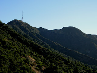
Hiked Griffith Park on Tuesday, June 26; hiked Altadena Crest Trail on Saturday, June 30.
Hiked these before my last little hike to Sturtevant Falls, but didn't get around to posting them.
I finished the month of June with 41 hikes, which means 100 hikes for the year is still not out of the question, though I'd need to average ten hikes a month. However, the hot afternoons have been a real deterrent to afternoon hikes, even though it still hasn't gotten REALLY hot, yet.
Griffith Park was another return to the Observatory, doing some paperwork and still not actually working there. Sometimes, I'm convinced government makes its hiring process an endurance contest, to be sure you *really* want to work for them before they hire you. Since I was told I was hired, it's been two trips to Van Nuys, two to the Observatory, and one downtown. Still not gotten to the scheduling part. Hopefully, soon!
I headed up the Mt. Hollywood trail, from the north end of the Observatory parking lot (again). As a variation, when I reached the point where the trail splits with one path looping up the east side of Mt. Hollywood and the other looping around the west, for the first time, I took the east route. I'm pretty sure the right is a longer way to the top, but I had not interest in hitting the top, anyway.
The right path eventually turned around the side of the mountain and began heading south. That's also where Dante's View is. I thought it was on the other side of the mountain, but I was mistaken.
From Dante's View, there's about a 270 degree view, centered more or less due east, covering due north and due south, and stretching some to both southwest and northwest. It's always harder to make out locations than you'd think, but I could obviously see the Golden State Freeway (I-5) and probably the Ventura Freeway (CA-134, in this area). Probably also the Glendale Freeway (CA-2). I was pretty sure I could see the hills where Elysian Park (Dodger Stadium) should be. However it, sort of like the Rose Bowl, actually don't stand very high above the surroundings. They're not very visible, unless it's night and the stadium lights are on.
Right after Dante's View, a trail makes its way along a ridge line to the east. That trail would eventually descend toward's Griffith Park's golf courses, on its east side.
After enjoying the view for a few moments, I made my way to the north end of these Hollywood Hills, and covered a section of trail I took on my way to Cahuenga Peak, a few weeks ago. Made my way a bit to the west before dropping down, but did not find a good access to a public road. In fact, by this time, I was getting hungry. My eating habits discussed in the previous post got to me, and, by the time I approaching a level point (still 1/2 mile or so from a public road), I gave up and started looking for a path back to my car. Too hungry and too tired to keep exploring, I was already thinking of dinner.
Before I had begun my descent, I noticed the Autry Museum, in faux mission architecture. Just west of the Autry is a huge parking lot that's used by the L.A. zoo. It always seems empty.
The zoo itself is not very visible from this vantage point. I'm always surprised by how small an area it covers, since it seems huge when you're walking through the zoo.
During my meanders, I also passed the city compost location, where the green-oriented can drop off their green waste for composting.
Then I found myself heading up a ridiculously steep road that ran along what looked to be a habitat restoration hill. May not have been, but it was one big and steep hill to climb.
Eventually joined a busier trail that headed back to Mt. Hollywood.
Bypassed Mt. Hollywood and got back to my car not too long after sunset. Just thinking about food by this time. Probably 5 miles of hiking for the day. Maybe more, but I was too tired to care.
On the 30th, I took another short hike, just along the Altadena Crest Trail. Forgot my camera, though, so no shots. I started from the Pinecrest access point and headed west, to Zane Grey Terrance. Then I walked out of Zane Grey, then north on Loma Alta. Just north of the home at 1101 E. Loma Alta Drive, there's a new trailhead. I took that trail just a few hundred yards, then bushwacked along a use trail, eventually getting back to the Altadena Crest Trail. I definitely wouldn't recommend this as a regular course of action. This was another situation of me getting hungry and tired. At one point, I just sort of tossed myself down on to the ACT. It was one of those controlled falls, which I prefer to uncontrolled falls: Jump, tuck, and roll. Definitely not recommended.
About four miles roundtrip, I would estimate.
A trailmap of some recent Arroyos & Foothills Conservancy trails (including some I covered today and some I've covered in past months) is linked here.
To the Top of (the Funeral Mountains') Pyramid Peak | Rain #1
-
The last quarter of 2025 has not been kind to Death Valley National Park.
Major flooding occurred on September 19th, wiping out many roads that'd
only rece...
1 day ago


No comments:
Post a Comment