Wednesday, May 10, 2023

Liberty Bell Arch trail, Lake Mead NRA, AZ

Hiked Sunday, May 7. Been out this way numerous times, but possibly not since 2019. It's become a little tricky in recent years, as Lake Mead NRA has instituted a summertime closure of this trail, from mid-May through mid-October, because stupid or unprepared (or both) people used to hike hear in full mid-day heat, and either die or need rescuing. I don't like the idea of a full seasonal closure, because there will almost always be days during the closure period when the temperatures abate, or you could go early or late to avoid the worst heat, and certainly complete this hike safely.

Unfortunately, that's not how they do things.

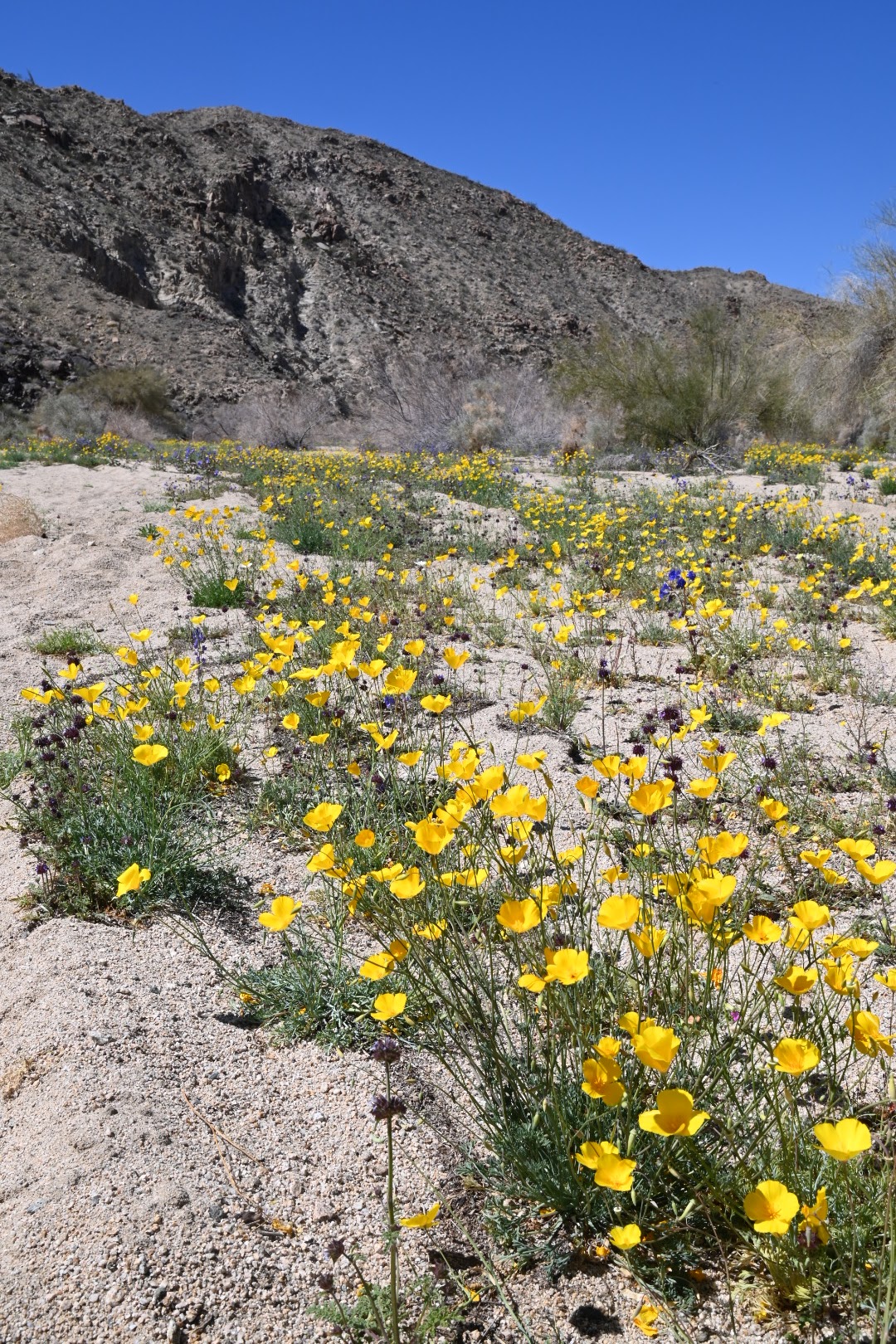
I would like to have taken this hike about a month ago, because I thought there was a chance of some decent blooms this way. And, sure enough, I saw a lot of spent brittlebush along the way. Not nearly as dense as what I saw down by Palm Springs, but it would have been nice.

As it was, there were only a few blooms, including a few showy (but nearing the end of the bloom) white flowers on a bush, which I think might be sand blazing star. Also, later in this post, you'll see some of what I think are yellow tackstem, which sprouted in cracks amongst the volcanic rocks.

I got a pretty late start, as I spent the morning with my wife, wandering around Boulder City's Spring Jamboree. I figured it would mostly be "crap," meaning old stuff, antiques if you collect them, dust magnets if you don't. But they also promised an "outdoor expo" as part of the event.

Well, it turned out the outdoor expo was about five vendors, including REI. They had a national park trivia contest, and I obviously national parks and trivia, so I came back for that and won a small bag of goodies.

I only mentioned that because I was debating a trip to "Spooky Canyon" after I got back, but found myself a little too tired to want to extend my trip. As it is, this was about 5.5 miles roundtrip. And, although only about 80 degrees, it must be the dryness that makes it seem hotter and more draining.

The trailhead is for the White Rock Canyon trailhead, which is about four miles south of the O'Callaghan-Tillman Bridge, off U.S. 93. The parking lot is on the east (left) side of the highway, so you'll have to be in the fast lane as you approach it, and pull into the leftturn lane, before yielding to oncoming traffic and crossing into the parking lot.

The trail heads under the highway, then west, down a broad wash, which eventually narrows, in White Rock Canyon. The trail to the Arizona Hot Springs peels off to the left before you enter the narrow part of the canyon. After the second narrow point in the main canyon, the trail to Liberty Bell Arch climbs a hill, to your right. There is usually a sign on the rise, indicating the trail.

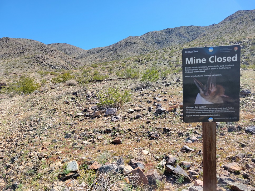
Had you continued forward another two miles or so, you'd reach the Colorado River. But the Liberty Bell Arch trail heads up some side washes and gains altitude. Evidence of mining is plentiful, and many of the side trails do lead to additional evidences.

After reaching a rather impressive viewpoint, the trail then descends steeply for a bit, before making a run towards a butte. Liberty Bell Arch proturdes towards you, and only becomes apparent when you have a bit of an angle between you and the butte.

The trail passes within a hundred yards or so of the base of the arch, which is very large. NPS photos often show brittlebush blooming below the arch, but I think so many people have trampled their way to the arch opening that I saw very few dead brittlebush on the way up. Mostly, just creosote bushes.

By contrast, there were a lot of spent brittlebush on the other side of the trail, away from the arch.

Continuing past the arch gives takes you to a spectacular overview of the Colorado River. You'll see part of the O'Callaghan-Tillman Bridge upstream, as well. Some thousand feet below, you may see kayakers on the river, and people camping on the shoreline. Meanwhile, looking to the east, you'll see U.S. 93, where you came from. Because of the line of sight and proximity to a major highway, you'll likely have cell phone reception for much of your hike.

Retrace your steps to return to your car. It's largely uphill on the return, and the sandy wash the last mile or so is much slower going on the return than it was on the way out. You may decided to stick to the high ground on the right. Firmer ground makes the going faster, even though it's a bit out of the way.

On this particular trip, I noticed three sets of shattered glass in the lot, which means auto burglaries can be an issue, here. I was actually happy when I got there that the lot was pretty full, with some people sitting in a pickup bed, and others coming and going, incluidng an NPS truck. For all I know, he was there to take a report on a break in. All of which is to remind you to take care, and make sure no potentially valuable objects are in view of your car. Obviously, if you can have someone drop you off, or stick with the car, that would be even better, but that's not a really great solution.

Wednesday, April 26, 2023

Pacific Crest Trail, Near Haugen-Lehmann Way, Whitewater, CA

Hiked April 19, 2023. Very short hike on my way to an astronomy outreach event in Twentynine Palms, at Sky's the Limit. This was an NPS-sponsored event, with Joshua Tree National Park recognizing its volunteers, and welcoming visitors to a small night sky event.

I had driven by here the previous Saturday. And, had I been in the slow lane as I passed Haugen-Lehmann Way (Exit 111 on I-10), I would have exited and explored it, then. As it was, I ended up heading to Mission Creek Preserve, where I had a very nice hike.

But when I got a last-minute notice of an event at Sky's the Limit, I decided I would take advantage of this, both to try out my new 10" Dobsonian telescope under dark skies, and to stop by along the way for a visit to this area around Haugen-Lehmann Way. So I used four hours of vacation time, left work around noon on a Wednesday, and headed home to pack.

Got on the road before 2pm. Unfortunately, there was an accident on the freeway not far from my home, which delayed me. So, by the time I got out to Haugen-Lehmann, I figured I only had about an hour or so, maybe a bit more, before I would need to continue on. I'd need to get to Twentynine Palms with enough time to eat dinner and set up my telescope before it got too dark. Didn't want a repeat of what happend the previous Saturday, when I got to an observing spot well after dark, but then couldn't figure out how to assemble my truss-tube telescope without the manual.

I've had the telescope since December, but only set it up a few times at home. Weekends came and went with either clouds, me being sick, or me having conflicting commitments, so I never got to take it out under dark skies. Indeed, the time before I made it to Joshua Tree (when I hiked to the Golden Bee Mine), the evening turned completely cloudy.

So, quick visit. I exited at Haugen-Lehmann, headed north, drove until the road t-bones into Cottonwood Road, then turned right (north). When the pavement ended, I parked and walked the few hundred yards until the Pacific Crest Trail crossed the road. Then I walked along the trail about 3/4 of a mile, taking a lot of pictures along the way (I also took a few before I got to the end of the pavement-- I think that first shot is from the roadside). Spectacular, thick brittlebush all around. A few patches of Fremont pincushion. Very few lupine and other flowers. But, man, that brittlebush!

Happily, after my hour or so of poking around here (too short to qualify as a formal "hike" under my traditional definition of three miles, minimum), I continued to Sky's the Limit, and had a successful outing with my new telescope. Some quirks, that I'm still figuring out, but I'm happy with the purchase.

It's likely that the summer-like temperatures are rapidly drying these flowers out, but a pretty immediate trip might still be rewarding.

Wednesday, April 19, 2023

Mission Creek Preserve (Sand to Snow National Monument), Hiked April 15, 2023

Hiked Saturday, April 15. Hiked out this way once before, almost two years ago. The difference in the appearance of the landscape was striking.

Unlike last time, this trip was in the midst of a very good wildflower bloom, the product of well-above average rains in southern California this winter.

Also unlike last time, this trip was rather impromptu. I was driving east on I-10, towards Joshua Tree, and the hills to my left were covered in yellow flowers. Britlebush was thick.

I gave some thought to making my way off the freeway at Haugen-Lehmann Road, and heading north from there. The Pacific Crest Trail passes near here, crossing over those mountains, then heading along the Whitewater River. I hiked this segment of the PCT during my original 100 hike year. I covered sections of the PCT further "north" on several other trips, including 2010 and 2011. Haven't been in the Whitewater drainage must since then, however. It seems likely I haven't been here since 2015. I should probably try to visit again, soon.

But that's not the point of this post. :D

Since I hadn't planned this hike, I didn't have the gate code or permission to drive beyond the boundary gate. I had lots of company, as the small lot at the gate was full, and cars parked along the edge of the dirt road. I joined them there.

If I just wanted wildflower photos, I could have gotten plenty just on the drive to the gate, and within 100 yards of the gate. But I'm a hiker, and I was going to hike. So I laced up my boots and headed past the gate.

Wasn't sure how far I was going to hike, but I only stuck one 28 oz bottle of Powerade, and one .5 liter bottle of water. But it wasn't that warm, so this seemed sufficient.

Started out photographing right near the gate, then crossed through the gate, and shot some more right around the picnic area. Took a while before I got actually moving along the road. According to the signage, it's 1.6 miles to the end of the road, where there's running water (not recommended for drinking) and flush toilets. Yeah, it's kind of a surprise to find that out in the middle of nowhere.

Near the gate were lots of brittlebush and lots of Fremont pincushion. Purple phacelia were also common. Later, I came across patches of purple owl's clover.

The purple phacelia were tricky. They grew under the protection of other plants, so they did not stand out directly. But their density gave a purplish tinge to many of the longer viewsheds along my hike.

When I finally got to the "Stonehouse," I saw why the parking outside the gate was full: The parking at the Stonehouse was also full. Lots of people who did call early enough and got the gate code had been approved, so later would-be visitors were denied.

So this was 1.6 miles later, and I still felt great. At this point, I was still debating if I would try to find the viewpoint for San Gorgonio or just continue on the PCT to the area I got to, last time. But I was definitely open for either.

When I finally got to where I assume the San Gorgonio view trail departs, I was still feeling like heading the other way. Just seemed like I'd get a better view from the high point I knew the PCT would give me, versus what I expected I'd see from the other point. But still haven't been there, so it's an open question. :D

More purple phacelia among the other plants. Desert Canterbury bells also became more common. Didn't see any desert poppies until I was well on my climb up to my PCT viewpoint. Oh, yes, and several yucca in bloom. One along the road looked like a Joshua Tree, but I didn't look carefully enough to be sure.

My turnaround point was about six miles total from my car (as measured by the Alltrails app on my cell phone). From here, with peripheral vision, you can see both Mount San Jacinto and Mount San Gorgonio, simultaneously. You can also peak into parts of the Whitewater watershed, to the left of San Gorgonio, and up and down the Mission Creek watershed.

While near the top, admiring the view and taking some shots, the hum of honeybees suddenly became loud, and a swarm started descending around me. While I'm told bees in swarming mode aren't aggressive, I didn't want to test that theory while the hundreds of bees came down. So I grabbed my bag and jogged a hundred yards or so, to get out of the LZ they had selected. Stopped, and took several photos of a yucca, with Mount San Jacinto as a backdrop.

While doing that, I heard the hum of a drone. Shouldn't be possible, given I was in a wilderness area. Not sure where the operator was, but I suspect he was back at the Stonehouse. Although I had walked over four miles from there, a lot of that was zig-zagging up to where I was, so possibly no more than two miles from the stone house. I mean, it's possible some longer-distance PCT hiker was carrying a drone on the trip, but drone operators tend not to be long-distance hikers, so I doubt he was further from the trailhead than I was.

Returned the way I came. Just about 12 miles for the day. My boots felt a little loose, but, thankfully, no blisters. But pretty tired. Longest hike of the year, I'm pretty sure.

Friday, April 14, 2023

Redstone, Lake Mead National Recreation Area, NV, March 26, 2023

This was a nice walkabout, from March 26, 2023. I've been here before, at least twice in daylight, and twice after dark.

It's adjacent to Northshore Road, NV-167, and there's a fairly large parking area and vault toilet nearby.

In this case, I parked about 1/2 mile west of the parking area. I wanted to explore a slightly different part of Redstone from on previous visits. Lots of photogenic sandstone here, too. I also continued south, heading up a ravine and out of Redstone, eventually achieving the edge of the watershed.

Took some video from the edge, but it didn't loaded right. May try uploading again, later.

Slightly disappointed to discover achieving the ridge did not give me a clear view of the Lake, to my south. Still many intervening rises. But the Lake to my northeast was blue and beautiful.

Meanwhile, from Redstone, staying low and heading further to the southwest were more red sandstone protrusions, so more places to explore on future visits. This is all the same "Aztec sandstone" that you have at nearby "Bowl of Fire" and "Valley of Fire," as well as Red Rock Canyon NCA and "Little Finland." No shortage of places to explore this formation. Still haven't been to Little Finland, and, with the weather suddenly turning to summer-like in southern Nevada, probably not heading there until at least the fall.

The nice thing about visiting less-visited areas is that the sandstone is less worn. Fewer feet to tromp down on the fine ridges that protrude from the surface. Of course, I try to minimnize my impact, and there are a lot of places I don't even try climbing. But I did detour and scramble for a lot of the arches I found.

I can't remember if I noted a website I found with geo-referenced arches, all over the area. The problem (not really a problem) is that there are so many arches that, at some point (in my case, a while ago!) you get more enjoyment out of just wandering and finding the arches yourself.

As the weather warms, my hiking may need to rise to higher altitudes. But, of course, there may still be some cooler weekends when I'm able to hike. If so, might yet do some more daytime hikes in the area. I also want to do some more night time hikes in the area, to aim for some nice skyscapes.

On a semi-related note, my America the Beautiful pass expired at the end of March. I'm likely heading to Joshua Tree this Saturday. Not sure if I'll buy a new pass this weekend, or wait until next month. If the latter, I'd have to do my daylight hiking outside of the park (maybe Whitewate Preserve, which I haven't been to in a while). Because this next trip is mainly for some night sky viewing, I don't necessarily have to do that inside the park. If Sky's the Limit were open, I'd probably do my viewing there. But pretty sure they won't be officially open on Saturday night. I mean, you can set up there, but without the vault toilets, it's much less convenient for night time use.

Since I know I'm going to be buying an annual pass soon anyway, waiting a month doesn't have much effect. I'll have to buy one some time this year, then one the year after that, then the year after that. Then (assuming they still exist and I'm still able to travel, of course) I'll be eligible for a lifetime Golden Age Passport.

Obviously, in the big scheme of things, spending $80 a year for unlimited federal land entry fees is still a bargain, and not that big a deal. But paying $80 (or what ever the price is when I get there) for life is even better, assuming I live long enough to be able to enjoy it.

Friday, March 31, 2023

Golden Bee Mine, Joshua Tree National Park, CA

Hiked March 18, 2023. Thought I'd take a run out through southern Joshua Tree, in case wildflowers were blooming. Also hoped for a clear night sky, so I could do some astronomy. Alas, the second part was completely clouded out.

Because the intial plan was for astronomy later, I poked around Alltrails and looked for shortish trails I could take during the day, hopefully short enough that I wouldn't get too worn out to want to head out again, after dark.

Golden Bee showed to be about five miles round trip, which is pretty managable, even if I did some short wildflower walks earlier. Yet, in real life, the five miles still made me tired enough and took long enough that, by the time I finished and got into Yucca Valley, I was not entirely disappointed when the clouds moved in and made astronomy impossible.

Alltrails has the hike as starting from the Cholla Patch parking area. Figured I'd park there, on the assumption there'd probably be portapotties and what not there. There were no portapotties, but there were a lot of cars. Despite the congestion, when I got there (early afternoon), there were plenty of parking spaces vacant, despite the many cars parked along the road outside of the parking area.

From the parking area, you're supposed to walk east along the road about 1/2 mile before turning to the south. So even though I could have "cut the corner," I figured I'd follow the path as shown on the app, at least on the way out.

About fifty yards after making the turn, I could see that I was on an intermittent old jeep trail, obvious in parts, but less obvious in others, especially when it crossed some washes. But the general direction was clear, so I only needed to check the app when I felt I was off the path. Moved pretty quickly, except at the wash crossings. As I approached the hills in the distance, road cut scars on the hill clarified my destination.

As I started up the actual hill, the "Mine Closed" sign was there, indicating to me both that I was on the right path and that even if I was inclined to enter the mines (which I'm not!), I shouldn't, on account of white nose disease.

Evidence of past mining became more frequent as I climbed, although some "ruins" were just completely collapsed wooden structures. Scattered cans, barrels, cables, and other errata were also visible.

At a place where the ravine split, the app indicated I should go to the left. More climbing and more significant structures were revealed. Not sure if there would also have been things to the right.

There are certainly larger and more expansive mine ruins elsewhere in the park, but this one promised to be emptier, despite the crowded start. The mine is not part of the "official" hikes listed in park publications, and there's no signage regarding it at the start. And, indeed, I passed only one person returning as I walked towards the mine, and passed none on my return. This, despite the overflowing parking lot at the Cholla patch.

Somewhere upon reaching "the end," I checked my app, and it said I had walked just under 2 1/2 miles. Unfortunately, because of the crowded parking lot, I felt rushed to get into my car, then get my car out of the lot. So, as is frequently the case, in my haste, I forgot to shut off the app recording. As a result, I don't have an actual measured distance for the total hike, and the recording has a good distance of me driving towards Yucca Valley.

I did cut the corner a little bit near the end, because I could obviously see the parking area and knew I did not need to walk the longer route to get back to my car. So probably only about 4.5 miles total walking for me. Probably another 1/4 mile if I had returned the way I went.

There were scattered wildflowers along the way, especially in the washes. Nothing "superbloom" in density, but lots of individual specimens. I took quite a lot of pictures with my dslr, but the Snapbridge app kept crashing on my phone, so I couldn't transfer those flower shots from my dslr to my phone for processing. So my post here is just cell phone shots, that were just resized for quicker upload and posting.

I posted this hike over a week ago on my personal facebook page, noting that I didn't know what was mined here. A friend informed me that it was gold, which makes sense, given the name. The other part of the name was also relevant: He said the water tank was, "back then," infested by bees. Not surprising, because bees in the desert are always looking for water. Hence, Golden Bee.

He also told me the bees were killed by the addition of cyanide to the water. Of course, once he told me it was a gold mine, I had already considered the question of, "I wonder if the soil here is contaminated by cyanide?" I'm not a chemist or a miner, but I do know that cyanide is used to leach gold apart from crushed ore that comes from a mine.

In any event, a nice hike, and I had no intent to eat the dirt or drink water from the likely-cyanide-laced soil around the mine, so I assume I'm safe. It was nice to see someplace I hadn't been to before, despite my many visits to Joshua Tree. Glad I visited.

Since this is not an "official" trail, it's not as easy to follow as those "real" trails. But, with the app, it was an easy hike, though with some steeper areas up gravelly slopes near the end, and some uneven parts as you enter and exit the many washes you cross along the way. Without the app, just heading in the general direction, you could likely find the evidence or road cuts to take you to the mine. But the app definitely makes it easier.

Monday, March 27, 2023

North Palm Springs and South Joshua Tree

From Saturday, March 18, 2023. Not really much in the way of actually hiking, but part of a longer excursion.

I saw the field of desert dandelion from I-10, as I passed through North Palm Springs. My fitbit just went off, telling me I needed to walk, which was fortuitous timing. I exited at Indian Canyon Road, hit the Pilot/Flying J there, bought some food for lunch and dinner, used the restroom, then headed back out on to Garnet Avenue (basically the frontage road to I-10, here). Drove west maybe a 1/2 mile, until I found a clear area to park. Walked maybe 200 yards back east, shooting as I went, then returned to my car. I loved the desert dandelion, the windmills, and, of course, Mt. San Jacinto, beyond.

Then I continued on my planned route, to the south entrance of Joshua Tree National Park. Just inside the park is the Bajada trail, which I had visited during a previous "superbloom," and it was impressive. Figured it might be too early this year, but worth checking out.

Well, turned out it was either too early, or it's just not going to bloom much there, this year. A few bushes of lupine made a nice photograph, and there were scattered desert poppies and yellow cups along the road. But not really worth a stop, at least on this day.

Further up on Cottonwood Springs Road (the road heading into Joshua Tree), the flowers got thicker, and spread beyond just the road runoff area. Desert poppies, yellow cups, and desert bluebells were the most common.

I'd say from roughly 3 miles to roughly a mile before the Cottonwood visitor center, the flowers were thick enough to be calling for you to stop. I stopped at a turnout and walked maybe 1/4 mile along one of the washes. Many to choose from, but obviously you should park at an actual pullout, so you don't run over the wildflowers you came to see, or have your car partially protruding into the road.

Later, I went on to the Cottonwood visitor center, figuring they'd want me to show my pass and be counted. But they just waved me along, so I left, without asking any questions. I was pretty sure I had already seen the densest flower blooms in the park at the time.

I drove on to the Cholla Patch, as my Alltrails app had suggested a short hike from there to a mining ruin. That'll be the topic of my next post, an actual hike. Should post that later this week.

Thursday, March 23, 2023

Ice Box Canyon, Red Rock Canyon National Conservation Area, NV

Hiked March 12, 2023. It's not news to anyone out west that it's been a wet year, and with several heavy snows at much lower altitudes than typical. A week before I got here, Red Rock was covered in snow. By the time I got here, the lower altitude snow was long gone. But the snow at higher altitudes was still melting, and that fed the waterfalls very nicely.

I've hiked this canyon before, and once, during active rain, when the water was flowing even higher than on this day.

Still, it was great hiking weather, a bit cool, but not cold, and, as mentioned, the water was running strong. With continued rain, I expect at least a decent flow on into April. Unlikiely I'll make this particular hike, again, but I wasn't able to visit Lost Canyon falls this trip, so likely I'll want to hit that by the end of the month. Maybe also Oak Creek, another short hike to a small falls.

On a somewhat related note, my America the Beautiful pass expires this month, and I always like getting in as many hikes as possible before it does. Yes, I'll buy a new one later in the year. But, who knows? Might be able to put that off into May, if I manage to schedule only not-federal fee area hikes in April.

Of course, because the recent rains have been so persistent, I wasn't the only one who had this idea of visiting Red Rock's waterfalls. The preferred parking area for Ice Box Canyon was full when I drove by that afternoon, so I had to continue on the one-way loop. But, no problem, I figured. I got the idea that I could just start from the Pine Canyon trailhead, then take "Dale's Trail" up to intersect with the Ice Box Canyon trail.

On the plus side, yes, this will work. On the minus side, I forgot how up-and-down Dale's trail is. Although probably less than two miles from Pine Creek trailhead to the junction with Ice Box, it took me about ninety minutes to get there. And since I started late (entered just before 3pm), I knew I was going to be pressing things to try to get to the waterfall, then back to my car, and out the gate by 7pm (when, in March, the loop road officially closes).

I mean, Dale's trail scenic enough. But I had forgotten how up-and-down this trail was, and it sure felt longer than I thought it would be. Also, even once on Ice Box, the high water meant there were lots of stream crossings, and detours up canyon side trails to try to get around the natural barriers in the creekbed. So, despite this being at least the 4th or 5th time up this trail, I wasn't moving very quickly, even once I was on the trail.

I think it was about 5:30pm by the time I got to the waterfall, which meant getting back to the car and out by 7pm was going to be tough. It would have been easy if I was parked at the Ice Box trailhead, but I already knew it would take me nearly 90 minutes just to get from Dale's trail back to Pine Creek (maybe a little less, since it's a net downhill hike on the return). So I walked rather swiftly. And, it being somewhat downhill, and over familiar ground, the return down Ice Box Canyon was definitely quicker than the way out.

I then decided I could move quicker along the paved road (despite it being longer) than along Dale's trail, so I went that way. After all, two miles on pavement, downhill, that's less than 40 minutes. So I wound up getting back to my car about 6:57pm, and reached the exit in my car at 7:01pm. No ranger handing out tickets, and the gate was open.

I don't know how strict they are at ticketing, but, so far, and I've never been more than a few minutes late out the gate. Do things change if you're 15 or 20 minutes late? Don't know, but prefer not to find out the hard way!

So about five miles of hiking for the day. As noted, great day for hiking, and very scenic with the water flowing.