Friday, January 1, 2016

Hike 2015.100 -- Monrovia Canyon

Hiked Thursday, December 31. Final Hike of 2015, although I didn't manage to post it until after midnight.

Wasn't sure where I might wind up for my final hike of the year. My worst-case scenario was that I'd do an after-dark hike in Griffith Park. But I wasn't looking forward to walking in the cold. Fortunately, I got off from work early enough to manage something before sunset.


Monrovia Canyon has several access points from near Mountain Avenue. The southernmost access is on Lemon Avenue, just a bit east of Mountain. There's also one east of Mountain, at Foothill. But I continued on up to Greystone.

Not certain of my total mileage from there. I'd guess about 1.5 to 2.0 miles from there to the park fee station. About 1/2 mile before the fee station is a gate that was locked. It said the park was closed, but there's an opening for hikers to pass around the gate, and I saw plenty of hikers on the road, so I figured it was just closed to motor vehicles, but open to people on foot.

When I did reach the fee station, I saw a couple of photocopied sheets of paper taped on various places, announcing that the park was closed on December 24, December 25, December 31 and January 1, but that hikers were still welcome.

Nice to have that confirmation.

Probably saw 20 or so other hikers on my hike. That's pretty empty compared to many other visits.

On my previous trip up to Monrovia Canyon Park, I noticed that a spur trail that had been closed and under construction since my first visit to this park (back in 2010). That first hike was before I started my blog, although it was one of my first 100 hike year. No write up or post on that original hike, but here's the write-up from my second visit to the falls, in 2011.

From the fee station to the falls via the falls trail is given by one sign at the trailhead as 1 1/2 miles, and by another as 1 3/4 miles. Add in the extra 1.5 to 2.0 miles from the fee station to Greystone Avenue, plus the 1 mile or so roundtrip from the main trail to the Cunningham Overlook (the spur trail that was open as of my last visit, and was still open, today), and figure it was a total of six miles or so, total. Total walking time was about 2 1/2 hours, which is why I'm thinking it was about about 6 1/2 miles or so, tops.
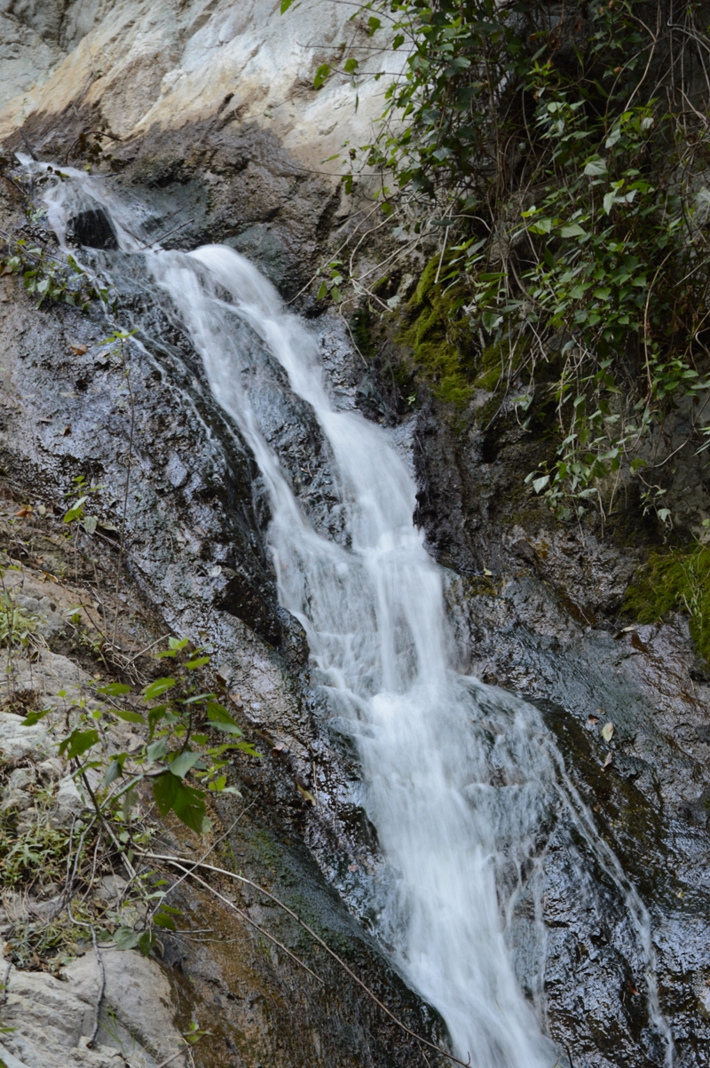
The water is flowing fine. Not as high as after a wet winter, but not bad, considering we're still on the tail end of a multi-year drought. Yes, rain since May has been above average, but average rainfall from May through December is usually not very much. So it was higher than I've seen it, but nowhere near the highest flow I've seen, here.

After finishing my visit to the falls (and after having taken many pictures, of course), I returned back the trail, to the turnoff for the Cunningham Overlook. This one is given as 3/4 mile each way from the entry station. It's no more than 1/4 mile from the start, so the entire spur is only about 1/2 mile, each way, or 1 mile, roundtrip, away from the main trail. In fact, it feels shorter than that.
It is a pretty steep climb for such a short trail, though. At the end is a small green bench. From there, there's a pretty good view to the southeast, and a mostly-open view up canyon, overlooking Monrovia Canyon Dam.
Spent a few minutes there, then returned. Good pace heading downhill. I probably averaged over 3 miles per hour on most of the downhill leg, minus the part heading up to the overlook. Particularly good pace heading down the part of the trail that's right adjacent to the road.
Once off the road, I also moved quickly, but kept scanning around, as is my habit. Up on the berm on the other side of the wash, which I assume is a settling basin, I saw a foursome of deer, silhouetted against the sky. Unfortunately, by the time I got my camera back out of my bag, they were now walking with a less open backdrop, and were harder to see and photograph.
Also, it was getting pretty dark, so even after upping the ISO to 800, the shutter speed was pretty slow, and the deer came out less than sharp.

It's funny how excited I still get to photography deer in a quasi-wild setting, considering how often I have seen them grazing on front lawns in Monrovia, or on the lawn at Griffith Park, or practically swarming around Zion Canyon. So I shot plenty, but most were of those pictures were completely unusable.
Got back to the car some time before 5pm. Sunset was about 4:50pm today, so it was not yet dark. Took surface streets back home, just in case of rush hour / long weekend traffic, and to avoid running into possible parade-related street closures if I had taken the freeway further west before heading south.

Easy hike. Not much of a crescendo to my third year of actually making 100 hikes. And I'm sure my mileage was probably only about 1/2 of my first 100-plus hike year. Still, nice to get some extra activity in. I think the Fitbit helped. Maybe more on that, later. I still have a number of 2015 hikes to blog, and, of course, hope to continue frequent hiking into 2016.

Happy New Year, fellow hikers!

Monday, December 28, 2015

Hike 2015.095 -- Los Angeles County Arboretum

Hiked Tuesday, December 15. Had a short day at work, but, with traffic, wound up with only a few hours to try to squeeze short hike in. So, given my newly-joined member status here, decided to return to the Arboretum for the second time in as many weeks. However, it turned out this was the third Tuesday of the month, which is always free, anyway.

The arboretum closes at 4:30pm. I was wondering if that was a hard closure or a soft closure. In other words, do I need to be out by 4:30pm, or do I need to be heading towards the exit by 4:30pm? Turns out, it's the latter, both at the Arboretum and at the Huntington Library and Gardens, which I hiked a few days later (again).
The main difference between this trip and the previous one is probably the peacocks. My wife commented on my lack of peacocks, which are one of the arboretum's bigger attraction. So I made a point of getting some shots of a few, and got a couple that were worthy of being shared.

Overall, I was more in "walking" mode, and less in "photography" mode. Doesn't mean I didn't get a lot of pictures, anyway. But, mainly, it was about trying to make sure I got my 3 miles+ in before getting kicked out.
In addition to the peakcock, I also ran across a few more sculptures I found interesting. This one here was based on the Joni Mitchell song about paving paradise. It only becomes obvious after you look at the little "ticket" carved into the top of the tree stump on which the woman is standing.

The next one was at one end of the "Serpent Trail," which obviously weaves through a small section of the park. It's also kind of neat, as the trail just looks like a trail, but it's also designed to have bits of scales and what not along the way, to look more snake-like.
Also, you had to walk to a short dead end of the trail to discover that the one end was a snake's head. There is no obvious tail at the other end, however.
Something else I learned was the name of the tree that produces those crazy red or pink "flowers." They're huge, pretty, and very common around Los Angles, and now I know their name: Silk Floss Tree.

As noted previously, I got there late, and the sun was rapidly setting. Of course, for me, that's a plus: nice, soft, red-tinted light, long shadows, lots of texture to the flowers and leaves. It's the same with my previous visit here and to the Huntington, and my next one, as well.
Kept walking fast and snapping pictures, and no one told me to leave, even as 4:30 approached. Still, I started my way towards the exit, Snapped some nice shots of the fountain and mountains.
After i exited, i continued shooting across the fountain at the entrance, at some Canada geese. The photos came out okay, but weren't very interesting.
They did have the benefit of giving me a bit more exercise, however.

After the shots across the front fountain, I made my way into the parking area, near my car, and noticed a number of peacocks, walking around a street that was across Baldwin Avenue from the Arboretum.
I observed that these nearby streets must really get a lot of peacock traffic. And I suspected that local coyotes must also come down into those streets to hunt those peacock. Must get pretty noisy down there.

Anyway, I'm calling it three miles, though I may have walked a bit more, criss-crossing my steps, to cover more ground and get my step count up. Not a bad way to end a day, though a lot more manicured than most places I hike.

Saturday, December 26, 2015

Hike 2015.097 -- Ryan Mountain, Joshua Tree National Park, CA

Hiked Friday, December 18. After finishing the Contact Mine hike, it was getting pretty late, and I determined that the only reasonable hike I could manage in the time remaining would be Ryan Mountain. I've hiked this trail many times, and many of those times as sunset approached. Nice view over the desert on this one, and the trail's wide and easy enough, as well as short enough, that you can come down after sunset and still make it to the car safely.
This trail begins roughly midway between the North and West Entrances. It's also right off the pavement, so there is no off-pavement driving involved, either. It's just sort of on the way to where you'd be going, anyway.
Started around 3:30pm. Sunset was around 4:30pm. So the shadows were already getting long as I began. Lots of puffy contrails to complement the high cirrus clouds, white against a light blue background.
There were probably less than a dozen hikers heading down as I headed up. And, sort of as I expected, there was no one at the top when I got there. The sun set within minutes of my reaching the top. I took a number of photos of the setting sun, the clouds, and the Joshua Tree atop the mountain, then headed back down.
Pretty dark by the time I reached the bottom. The darkness was exaggerated by the fact I was also wearing my prescription sunglasses. I do that a lot.
Roughly three miles round trip. Altitude gain is given as 1070 feet, but, honestly, it seems like less. Peaks given as 5461 which is low enough for me that altitude is not too big of an issue.
Because of the short distance involved, you never really escape the road noise, and shouting people can sometimes be heard from atop the mountain. But, in between, it's just the sound of the wind. Nice little hike to end any day in Joshua Tree.

Friday, December 25, 2015

Hike 2015.096 -- Contact Mine, Joshua Tree National Park

Hiked Friday, December 18.

Before Joshua Tree became a national monument (and, later, expanded and turned in to a national park) much of the land was subject to mining and/or grazing. The remnants of that past are on display in many parts of the park. One such place is here, at Contact Mine.
Over the past five years, I've done most of the hikes listed in park handouts in Joshua Tree National Park. Yet, this year, I had not made a single trip to the park. So I had an inkling that I might want to head out here on my next available opportunity.
Hence, in the days before my off day, I spent much time going over my National Geographic / Trails Illustrated map of Joshua Tree National Park. In doing so, I noticed the short trail to Contact Mine. I had never been here, yet it seemed like it would be easy to find. The trail seemed to start just inside the North Entrance, and the map showed it as 3.6 miles roundtrip. I figured I could do this hike, then still have time for a short additional trail, despite my late start.
The North Entrance is accessed from Twentynine Palms, just south of Highway 62. There's a visitor center near this entrance, just as there is one north of the West Entrance, out of the town of Joshua Tree. If coming from Los Angeles, Twentynine Palms is another half-hour or so further east.

[Note -- a new visitor center opened in Twentynine Palms proper, on Highway 62. The old visitor center, on Utah Trail, is now an NPS administrative building].

Upon reaching the fee station at the North Entrance, I asked the ranger there about the hike to Contact Mine. He seemed to suggest explaining directions (for the hike, I guess) would be too complicated, and that the trailhead also would have no mention or signage indicating the Contact Mine. I mentioned that I did have the National Geographic / Trails Illustrated map, and he said that if I could navigate by map, I could probably find my way.

This turned out to be true. At the exhibit at the parking area (about 1/2 mile inside the North Entrance of the Park), only mention of the California Riding and Hiking Trail was made. That one starts on the east side of the road, then loops along the northern portion of the park, ending near the Black Rock area, far to the northwest. I had hiked around that section during my first 100 hike year, when I went to Eureka and Warren Peaks.
Meanwhile, today's hike started on the west side of the road. A well-defined trail headed west from there, but had no trail head sign indicating where this might lead. There was a large orange sign of a hiker this way, however, indicating that this was a hiking trail.

[Note: That's no longer the case, today. The Contact Mine trailhead has clear signage, now]

After a short distance traveling across generic desert growth, the trail entered a wide, sandy wash. Here, any trace of a trail would be obliterated with each rain. However, the orange hiker signs were generally spaced close enough that, if you had any question, you could walk a bit past one sign, and soon see the next. This continued for about 3/4 of a mile, with only a very slight gain in elevation.
Finally, the trail approached the hills, and a higher, berm-like barrier seemed to partially block the canyon opening. The trail went to the point of that berm, where obvious stone steps led up to the top. Rather than bounding over the uneven surface of the wash bottom here, the path stayed up for a bit, before dropping and crossing the wash a bit further upstream, then continuing on the other side.
There were no orange signs here, but I found the path rather easy to follow. The only confusing part was as I climbed up on the right side of the wash, and saw a very clear trail heading up the other side. I believe the trail on the left side (when facing the hills) is an old trail, and the one on the right is less steep and better graded, and so the "correct" trail.

After 1/4 mile or so, I saw some poles and barrier material on the hill, far above and to my right. Obviously some mining ruins there, but that was not the main goal, so I continued along the well-defined trail.
Even before dropping down to the bottom of the wash, again, I could see various ruins and barriers ahead and above. I carefully navigated my way around them, trying to avoid unnecessary erosion or damage as I made my way around these ruins. I spent about 15 minutes poking around here before returning the way I came.

As noted previously, this was about 3.6 miles roundtrip. Modest altitude gain. I would guestimate no more than 200 feet. Never far from the road, but this area did not appear to get a lot of foot traffic. Nice little hike.

Monday, December 21, 2015

Hike 2015.085B -- Oak Glen, Fall Color

Hike 2015.085B. Short walk in Oak Glen, from earlier this fall. Hiked Sunday, November 15. This was too short of a walk to count as a hike by itself, so I'm bundling it with my Stoddard Peak hike of November 14. Appears I haven't blogged that hike yet, either.
It's possible there'll be a swarm of "make-up posts" from earlier this year, coming down the pike. Some may spill over into the new year.
Although a short hike, the fall color was really nice. And, as has often been the case on my trips up here, there was a pretty good amount of cloud cover, which helped produce those saturated leaf colors.
Had a very photogenic goldfinch, pulling sunflowers out of a flower. Quite a feat of balance!
I also had some folks in some rather photogenic backdrops. Love those shots that give a sense of scale to those oaks.

Couldn't quite get the color right. I shot with the camera set to auto balance, shade, and cloudy, but none quite got the color right. The shade version was closest to what I saw, but still a little warmer than I saw. Still, definitely gets the mood, right.

Incidentally, this was a relatively recent trick I learned. It's what happens when I never actually read the manual. Didn't occur to me until around then (several years after I bought the camera) that I thought to experiment with those different white balance settings.

Most visits to Los Rios Rancho, I walk the circuit of trails. This usually does entail a walk through Oak Knoll Park, and the oak tree boughs that span over the park are always photogenic, as well.

Something else different on this trip was that I saw some chestnuts, growing on trees. Didn't know they grew chestnuts here. I don't know what chestnut trees look like, so it wasn't until I saw the nuts on the tree that I realized what kind of tree it was.
And this surprised me, because I know nearly all chestnut trees in the U.S. were killed by a blight in the early 1900s, but I guess these guys were isolated enough to survive the blight.
As noted in previous posts, Los Rios Rancho is located in Oak Glen, which is above Yucaipa, CA. From the San Bernardino Freeway (I-10) exit at Yucaipa Blvd and head "north," to Oak Glen Road. Turn left at Oak Glen Road, and it takes you right through the town. About a dozen apple orchards and numerous restaurants are up here. It's a fun place to visit, and gets really crowded around harvest time.

I hiked about two miles this day, about one mile short of my usual minimum. But I did get to go home with lots of apples and apple cider. ;D
Peak leaf color seems to come here after Halloween, but before Thanks-giving. Black oak are, I think, the main colorful native here, along with some willow. Non-native Chinese pistache and maple are also mixed in, along with some persimmon around the farm.
While the oak don't normally change to such brilliant colors as maple, soft backlight-ing (as on overcast days) gives some nice color and can help produce some really pretty pictures.

Saturday, December 19, 2015

Hike 2015.098 -- Altadena Drive to Henninger Flats

Hiked Saturday, December 19. Thanks to two short hikes I squeezed in yesterday (still to be blogged), today's hike was number 98 for the year. I will now only need a very doable two hikes next weekend, or at least two more hikes in the next 11 days. If it comes down to it, I'll do an after-dark hike up Mount Hollywood, again.
This trail starts off of Altadena Drive, just north of New York Drive. The trails drops down, crosses the driveway for the Nature Center, then passes behind the Nature Center before joining the regular trail, north of the parking lot. This adds maybe 1/4 to 1/2 of a mile each way to if you parked near the gate, down below.
The trail crosses Eaton Canyon Wash (usually drive, but occasionally full of water), then heads north. Pass Coyote Canyon (first sign on the right), then take the trail up Walnut Canyon. This joins the Toll Road after a short but steep 1/2 mile or so. Then follow the Toll Road to Henninger Flats. Good climb. About six miles, roundtrip. My Fitbit (set at 16,000 steps, or 6 miles) buzzed as I approached my car on the way back. Not sure how many steps I had before I left for the morning.
The weather changed dramatically, from perfectly still, to gathering storm by noon. By tonight, of course, the rain really let loose. It's the second time in as many weeks that a clear sky in the morning gave way to at least some rain by evening.
My two hikes yesterday were in Joshua Tree National Park. I'm going to try to get those posted this week, so I can post may 99th and 100th hikes before the end of the year (I hope). I also have a number of older hikes that I'd like to post before the end of the year.