 I was looking at my Tom Harrison trail map, "Angeles High Country," and I noticed there was what looked like a direct access to the Lower Monroe Truck Trail. I accessed this trail twice before: Once, from Big Dalton Canyon's Mystic Canyon trail, and once via the Poop Out Trail, which starts off of Glendora Mountain Road. I remembered having nice views from the top over towards Mt. Baldy, so I figured a return to that area, with all that fresh snow up on Baldy, would look cool.
To get directly to the Lower Monroe trail, I exited the 210 freeway at Grand and headed north. After a very slow two miles or so, I reached Sierra Madre Blvd. A right turn there, and two more miles, took me to Glendora Mountain Road (GMR). There's no stop sign there, but it is within 100 yards of the end of Sierra Madre Blvd, so when you see you're approaching a t-intersection with a stop sign just ahead, turn on the street just before that intersection.
 I took GMR north, past Big Dalton Canyon Road (where I accessed the Mystic Canyon trail) and past the roadside parking area for the Poop Out trail. Almost immediately past the wooden "Entering Angeles National Forest" sign, there's a small parking area on the right. It's right where GMR makes a hairpin turn to the left. With room for just three cars there, I had to park just before the parking area.
From the parking area, I walked about 50 yards up GMR to the gated entry, which was signed as Lower Monroe TT. "Good," I thought to myself. "If it's designated a truck trail, this should be nice, wide, and easy to follow the whole way." It's exactly the kind of trail I wanted, since I was getting a very late start today. (I didn't get to the trailhead until around 12:30pm).
 Well, surprise! Despite the gate and the name, this trail was wide and obvious for only a few hundred yards. Then it started crisscrossing the stream. Now, in the summer, I suspect there is no stream here. But with the recent rains, the water was running high. As far as rivers go, it wasn't very deep or very wide. But it did present a barrier. More importantly, it obscured portions of the trail.
Because the trail parallels and repeated crosses the stream, there were many areas where the trail became a stream. The path was completely under the rushing water. It wasn't terribly deep, but it was deep enough that you couldn't just walk through it, at least not without getting soaked.
 As a result, I managed to lose the trail for quite a while. With no obvious path, I headed up the west wall of Little Dalton Canyon. That wasn't the way the trail led, but I thought it might allow me to completely bypass the flooded areas and join the trail further upstream.
I was completely wrong on that count. But I did, at least, get above the level of the trees in the canyon bottom. That let me pull out my map and get reoriented. I could also see where the trail broke into a clearing further upstream. And that clearing was on the EAST side of the stream. Also visible was what appeared to be a trail running along the side of the east side of the canyon. The map confirmed that's where I'd be heading.
 By the time I finally got back on the main path and contouring along that east wall, I was feeling pretty stupid. My whole reason for starting on the trail I took was that the path was supposed to be less steep and easier than either the Poop Out or Mystic Canyon trails. Instead, the trail proved far harder to follow. It was also way longer, although I knew that part when I started.
Once the trail got out of the canyon, the going was much easier. As I climbed, I could look across to GMR. That road switchbacks to the south before climbing into the hills to the west of Lower Monroe TT. As my own path also swung to the south, I was treated to a view of Downtown LA, as well as the orange glow of the Pacific Ocean, with Santa Catalina Island easy to view in the clear, wind-swept skies of this late December afternoon.
 Unfortunately, the combination of my late start and my snail-slow pace while criss-crossing Little Dalton Creek was costly. At 3:15pm, knowing I had less than two hours of sunlight remaining, and knowing the last part would be at the bottom of the canyon, with repeated stream crossings, I turned around at around. At the turnaround point (about 1/2 mile before Peak 3397), I took a bunch of pictures, then headed back.
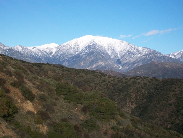
 The last three pictures in this post are some of those last ones. I've got a wide-angle shot of the whole bunch of mountains up San Antonio Canyon, plus close-ups of Mt San Antonio, one centered around what I think are Thunder and Telegraph Peaks, and
 one centered on what I think is Big Horn and Ontario Peak, with the clouds trailing to the south.
 Total distance covered was somewhere around 8 miles, with an elevation gain of about 1,200 feet.
If you hike this trail, keep an eye out for mountain bikes. Also, if you go when the water's high, stay close to the water. The trail is usually within sight of the stream. Just pay attention on the stream crossings and don't try to cut any corners, or you'll lose the trail and have a lot of bushwacking to do. If the water's high, bringing a walking stick and waterproof boots would make the stream crossings a lot easier.


Hey SkyHiker, nice write-up. Thanks for your comments on mine. Looks like we share some common experiences. Happy hiking!
ReplyDelete