 Hiked Thursday, April 7. Today was another "foiled" hiking day. I seem to be having a lot of those lately.
Yesterday, while poking around the internet, I somehow came across the existence of a redwood grove at Carbon Canyon Park in Brea. Images of stately, 200-foot tall (at least!) trees danced in my head.
 So, this morning, when it looked like the rain would, indeed, hold off until the evening, I decided to do this little hike. My plan was to go to Carbon Canyon Regional Park, park my car there, start off to the south, to the redwood grove, then backtrack and head east, into Chino Hills State Park. Figured I'd head up Telegraph Creek, and maybe on to Gilman Peak before backtracking to Carbon Canyon. This seemed like it would produce a very reasonable day of hiking.
Part 1 of this plan began more or less on track. I took the 57 freeway south to Lambert, headed east on Lambert Drive about three miles, then turned right, into Carbon Canyon Regional Park. This was shortly after Lambert crossed Valencia Avenue, and turned into Carbon Canyon Road (CA-142).
 The entrance to Carbon Canyon Park was unmanned, except by a vending machine. It was exactly like those parking permit dispensers I've seen in a number of colleges and universities (and undoubtedly other places). I fed it my $3 and received nothing in return. I was expecting a little piece of paper to place on my dashboard. Didn't get that, but the gate did rise, so in I drove, parking in the first lot I saw (to my right, the most northwestern of lots). I placed a note on my dashboard with the date and time, saying the machine didn't dispense a receipt. I'm not sure if that was necessary or productive, but I wanted to do what I could to avoid getting an undeserved ticket.
From there, I walked south, down the pavement, in the direction I figured would intersect with the "redwood grove" trail." In fact, this road ran into a muddy parking lot that had obviously been submerged recently. The grass around the pavement was saturated with water.
 I worked my way to the left, out of the muck, and eventually saw what looked like a trail access. Sure enough, across a shallow, six-foot wide creek, was a trail. A small green sign with hand-lettered white writing, said "Redwoods," and pointed to the right. So off to the right I went.
 Tall bushes (with carrot-looking leaves and bunches of tiny white flowers) lined the trail. Up ahead, I could see a large earthen dam. At modest intervals, rest benches were available, with information on redwoods posted to pass your time. The signs helped to build anticipation of the redwood giants I expected to see.
 The trail skirted a large detention-retention basin and got closer to the dam, before curving to the left, around the base of a hill. Sunflowers bloomed thickly on the slope. Round another bend, and there they were: Redwoods!
 Except they were a lot smaller than I antici-pated. Not 200 feet tall. Not even 100 feet tall, at least to me (although I have read claims of "up to 100 feet tall" ascribed to these trees). To me, most seemed to be in the 40-60 foot range, with some less than 20 feet tall and perhaps a few as tall as 80 feet. The grove is narrow, but stretches at least several hundred yards in length, and it's not entirely level, so judging tree heights is difficult. Still, I would suspect only a handful had trunks thicker than a standard trash can.
I think this is a matter of managing your expectations. There are a couple of sequoias on the the L.A. County Fair grounds that really are huge. I was expecting a whole grove of trees of similar size.
 I'm very curious how old these trees are. I read elsewhere that they were the left-overs from a bank promotion in the 1970s. Amusingly, I actually do have a vague recollection of a redwood promotion in my childhood. Home Savings, maybe? Regardless, 40 years old seems about right. I'm thinking I'll have to schedule a return trip here in about 500 years. Heck, maybe even just 200 years from now, these trees, if they make it that long, should be pretty impressive by then. :D
 After passing through the grove, I headed up to the right, where a well-defined trail headed up the slope, and approached a tract development of homes. From the top (maybe 200 yards from the edge of the grove), I had a nice view over the grove, as well as over the dam and over a field of thistle.
I think that, had I continued along the hiking/horse trail that I was on, I would have covered the full 3.4 mile loop described here. (Ironically, the post I found above was written by someone who follows this blog. How's that for "small world"?). Instead, I turned around at the overlook and looped my way through the redwood grove, then backtracked away from the redwood grove the way I had entered.
 Along the way, I got a peek at a couple of Norfolk Island Pine, which, like the Coast Redwoods, are non-native to the area. I then passed the trail access I took on the way in and continued east, with Telegraph Creek on my left.
 As the trail continued at the base of a hill, I stopped to take several flower pictures. I also shot a few longer photos, back to the small lake in the middle of Carbon Canyon Park. A snowy egret (I think) was standing out in the middle of the lake, with coots browsing on the shoreline.
 I intended to follow this trail into Chino Hills State Park, but after about 1/2 mile (from my initial access point), the trail crossed back over Telegraph Creek, then returned me to Carbon Canyon Road. Along the way, I had a good view of the "new" entrance station for Chino Hills State Park, which the map I downloaded yesterday said would open in early 2009. Yeah, they're running a little behind schedule.
 Once I got back to the east parking lot, I turned around and saw a sign pointing to Chino Hills State Park. So, yes, I was where you would normally be if you wanted to hike from Carbon Canyon into Chino Hills State Park. I backtracked a few times around here, both going along the trail and along Carbon Canyon Road. But, no, it could not be done this day. Foiled, again.
I made my way across the park, eventually returning to my car. Not sure about the distance I covered, I searched google when I got home for more information on this redwood grove hike. A post I found (previously linked, above) gave a distance of 3.4 miles for the loop. However, I didn't do the loop.
The path I took was probably around half that, since I did my return via the east trail head rather than looping all the way around the park maintenance yard. But I did double back a few times near the park boundary, and I walked a bit along Carbon Canyon Road, trying to find a hiking access around the construction at the Chino Hills entrance station-to-be. Figure maybe 2 miles?
Since it definitely felt like less than three miles (my arbitrary minimum to qualify as a "hike"), I intended to find myself additional hiking before calling it a day. I was thinking of maybe heading back around to the Rimcrest trailhead. But that seemed like a lot of driving, so I wasn't too keen on that idea.
 Instead, as I waited at the traffic signal where Carbon Canyon Park empties on to Carbon Canyon Road, I looked ahead and saw all that open space, and thought that perhaps a trail might exist "up that way." So, instead of turning west on Carbon Canyon Road and returning to the freeway, I headed straight. The road north of Carbon Canyon is called "Santa Fe Road."
 Not 100 yards north of Carbon Canyon, I saw a sign that said "Olinda Trail." The problem was that I wasn't sure if that meant "trail" as in "a place to walk" or "Trail" as in a homey synonym for "Road" or "Street." I paused at this "corner" and looked down the trail. Nope, I couldn't tell if this was a walking trail or a driving road. So I continued forward, north on Santa Fe.
After about 1/4 mile, a sign on the right pointed me to "Olinda Museum and Trail." Ah, NOW we're talking!
 I pulled into the small and empty lot. At the top of the lot was a cute little house that held the indoor displays and artifacts of the museum (obviously closed), and a number of large outdoor exhibits could be enjoyed even if the museum was closed. I stopped there on the way back. But, first things first: Off on the trail I went.
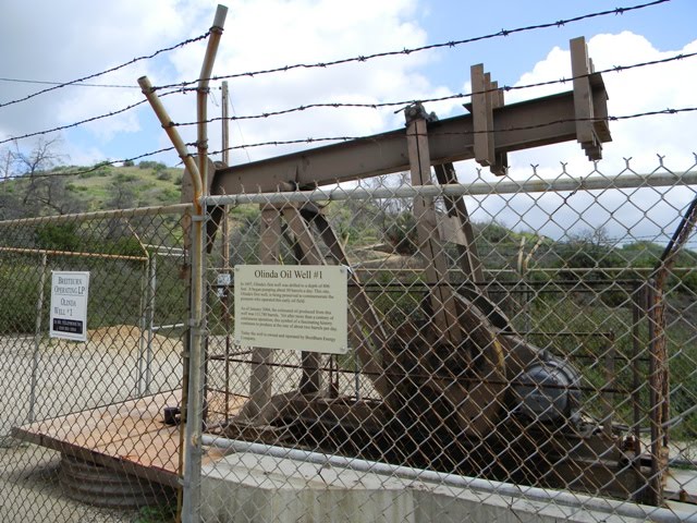 Although there were a number of signs here indicating a trail, none seemed to specify the trail's length. I did see it noted that this trail would have a 275 foot vertical gain. And the view it promised from on up there seemed to make the hike worth it. So off I went.
 At regular intervals, numbered "Trail" signs suggest that, if someone had the right handout, there must have been a lot that could have been learned about the history of this Olinda. What I did learn without a handout (but by reading the signs around the museum) is that this area had been developed for oil production back in the late 1800s, and that the field was still producing today. I also finally made the connection between the name of this city ("Brea") and the "La Brea" of mid-Wilshire Los Angeles: Tar. Duh. No bubbling tar pit here, but there were tar seeps that colored portions of the surface here dark. Indigenous peoples ("Native Americans") used these tar seeps to waterproof their woven products.
 Several signs warned of rattle-snakes in the area. I didn't see any of them today, but I did practically step on a gopher snake. I'm glad it was one of them and not a rattler!
Turns out it's a little less than a mile to the "top." Nice view to the south from there, so you can look over Carbon Canyon Park and see where you hiked earlier in the day. That's the picture at the top of this post.
 From the top, the official trail continues a bit further east before winding back down along a canyon. This section of trail is less well-defined and less worn than the earlier part of the trail, so I suspect most people just backtrack from the top back to the museum. However, because I hate backtracking, I continued over the top and on down the trail, keeping an eye out for snakes as I went.
 I was treated to a nice view up another canyon as I descended towards street level. The last 1/2 mile or so is mostly flat, first on a dirt road, then on a paved road. You skirt along a drainage ditch that separates you from some housing before the trail returns you to Santa Fe Road. Yes, this is where the first "Olinda Trail" sign I saw was. No stopping is permitted on Santa Fe, however, so I apparently did this trail "right": I parked where I was supposed to park and had a nice loop of a hike, which I later learned is supposed to be 2.2 miles in length.
 I walked up the sidewalk and returned to the Olinda Museum, wandered around the grounds for a few minutes, and took a few more pictures. Then I got in my car and drove home.
Roughly 4.4 miles for the day. If I knew where the trails leading away from the redwood grove went, and if I knew ahead of time that I wouldn't be able to continue into Chino Hills State Park, I probably would have taken those paths and gotten more distance in Carbon Creek Park. But then I might not have discovered the Olinda Trail. For a plan that was foiled by construction, it actually turned out pretty good. Discovering the Olinda Trail was a happy accident.


No comments:
Post a Comment