 Hiked Sunday, April 24. This is a "cross-country" hike, meaning it is mostly over unimproved terrain. It's definitely not for the faint of heart. Because of its complexity, this post turned out super long. Just warning you!
It is listed as Hike #10 in Hiking Mojave National Preserve, by Bill and Polly Cunningham, which I bought in the preserve visitor center at Hole-in-the-Wall, last October. I also googled "Table Top Mountain Mojave National Preserve" (without the quote marks) and got this page, from summitpost.org. And that was about it for this destination. [Edit--Now, when you do that google search, my own page comes up. Funny that way. Fortunately, my link to the other page and mention of the book will help folks plan their trip here!]
 Despite being a cross-country route, Table Top Mountain (or, simply "Table Mountain," as listed on my 1996 Tom Harrison "Recreation Map of the Mojave National Preserve") is a pretty obvious landmark, visible from miles around. As long as you can keep your destination in sight pretty much the entire route, and if you have a modicum of directional sense, you can always get there and back, even if you wind up taking a different route from the one your guide book might describe, or even if you wind up having to scrub your mission. A GPS, map and compass would make this even more fool-proof, but the high visibility of Table Top Mountain and its long, east-west running structure make it very easy to maintain your bearings.
 I was camping at Black Canyon Equestrian and Group Camp-ground, which is across the street (Black Canyon Road) from Hole-in-the-Wall Visitors Center. This photo here shows what Table Top Mountain looks like from where the Hole-in-the-Wall Visitor Center road connects to Black Canyon Road.
According to the summitpost.org post on this hike, the unmarked trailhead is 5.3 miles north of Hole-in-the-Wall. So I noted my mileage as I turned north on to Black Canyon Road. However, at 5.3 miles, there was nothing but a fence, posted "No Trespassing."
 I continued north, thinking that I or they had the mileage off (because summitpost says "some books" have the distance off "by two miles"). Of course, with Table Top Mountain now behind me as I drove north, I was pretty sure I missed the trailhead.
Before long, I was approaching Mid-Hills Campground, which I knew was too far. But all part of the plan: I had the summitpost distance of "or 1.7 miles south of the turnoff for Mid-Hills Campground" to work off of from the other direction.
 So I turned around, and again noted the mileage on my car's odometer. Just about 1.7 miles south, I came across what I eventually determined to be the parking spot: Just north of a cattle grate at the designated location, heading east from Black Canyon Road, was a dirt road and small, flat, potential parking area. A double-track jeep trail headed from this parking area further into the nearby hills. As advertised, there was no signage of any kind here, so if you don't know what you're looking for, there's no way you'd know to stop here.
I will note that, on my return drive, after my hike, my car's odometer found the distance from here to the turnoff for the Hole-in-the-Wall visitor center to be 5.0 miles (with 4.7 of those miles over unpaved road). I also noted that there was a watertank and windmill on the west side of the road, just .3 miles south of trailhead parking area.
It could be my car odometer is WAY off (understating my actual distance traveled by 6%). It could be summitpost.org is off by 6%. It could be a combination of these factors. However, given the lack of signage at the trailhead, knowing the correct distance is very important, so take my measured distance as an additional bit of information when you go off in search of this trailhead: If approaching from the south, start looking for a windmill and water tank about 4.7 miles north of the Hole-in-the-Wall Visitors Center turnout, and about 4.4 miles after the pavement ends. Expect your parking area to be on the right (east) side of the road, about .3 miles north of that windmill, and immediately after a cattle grate.
From the trailhead, summitpost leaves you largely on your own, to either choose "the ridge route" or "the sandy flats route." The Cunninghams are more detailed, although not necessarily more helpful with most of the route.
Summitpost accurately describes the parking area as "surrounded by low hills." In fact, Table Top Mountain is not even visible from the trailhead, despite it being visible from miles away in any direction. Also, when you do see Table Mountain, it will not appear as flat from this angle as it did when viewed from a distance, from the south.
 The tracks of the jeep trail head initially to the east or northeast, up over a small rise, before turning somewhat to the southeast. At .3 mile, the Cunninghams say your trail will take you "through a gate/fence." I'm pretty sure this gate/fence burned down in a fire (2005 or later), as now, as I felt I had walked .3 mile, there were only two burned posts on the south side of the road.
By contrast, the Summitpost says you should "hike the dirt road northeast over the first hill and head towards the windmill." However, no windmill is visible from the crest of that first hill. At the very least, it definitely wasn't obvious, because there's no windmill near the direction the trail is heading.
At the time, I thought perhaps this windmill had also burned. However, later in their post, it seems clear they are referring to the same windmill as the one the Cunninghams consider to be the jumping off point for their hike. But this one is well to the left and above the line of travel, and it's somewhat earth-toned, so if you don't know where to look, you won't see it.
Instead, the Cunninghams' description of hiking .6 mile from your car, then making "a sharp left turn at the junction" seems on target. By "sharp left," they mean about 120 degrees. This junction is also unsigned.
You are now heading north or northwest, and climbing somewhat. The Cunninghams write, "The trail climbs up a wash next to an old broken waterline for another 0.5 mile to a windmill/water tank used for watering cattle." Neither part of this description was immediately apparent, although after a few hundred yards, a sandy wash did appear on the right of the trail. Also, short sections (a few feet long) of white PVC tubing or longer sections (anywhere from a few feet to a hundred feet or more) of blackened plastic or rubber tubing were atop the road.
Along the way, you may note some double-track coming in from the left. That double-track leads back to the original east-west segment of jeep trail, and would have cut off some of the distance to get here, but with a slightly steeper climb.
 Just before I reached the windmill, I came across what looks like an old campsite. A fire ring. Next to that was an old rusty bucket, hung on the limbs of a dead tree.
The windmill and tank are behind fencing. However, the fencing is not posted "No Trespassing." Apparently, the "ridge route" would require you to cross this fence and head up along the ridge of the hills in front of you. However, there is no gate I could see in this fence, and no "zig-zag" opening for you to go where cattle fear to tread.
 Far as I can tell, to take the ridge route, you should slide under the barbed wire fence here (the bottom strand has no barbs). Or, if you want to take the longer but allegedly easier route, you "might" be able to take the trail that heads from the water trough to the southeast. It's a very faint trail at first, but gets clearer further down. It MAY be the way hikers take a round-about approach that eventually places them on the east side of Table Top Mountain, where you'd then have a relatively steep cross-country route up a grass-covered hill. However, I didn't find this trail until I came back from my hike, so I don't know if it really is a hiking trail, or if it's just the route cattle and wildlife take to get to the water trough.
You should also note a prominent rock outcropping, to the right of the windmill and tank. That's a landmark to help keep you oriented. On your return, you can aim for this target (or south of this target) to get back to the dirt road that will return you to your car.
From the windmill, I walked south, along the fencing, and continued along the fencing when it made a 90 degree turn and headed due east. I was still looking for a break in the fence. Never found one, so I kept walking along the fence.
 Although this is almost certainly not the route suggested by either the Cunning-hams or summitpost, it worked fine. The growth is minimal, so there's very little to keep you from maintain a straight line path. Every now and then, you might need to move left or right a few feet to avoid a larger shrub. A few boulders and rock piles are also along the way, but present no barrier to your direct east-west travel.
 This picture here was taken from atop the most prominent of these outlying boulder fields, not twenty yards from the fence line, looking west.
With no "No Trespassing" signs posted, and evidence of cattle grazing on both sides of the fence, I surmised that this was not a property line fence, but just a fence to separate grazing allotments. So, at a point where a sandy, plant-less wash went under the fence, so did I. Hard to say how far I had gone. I'd estimate between 1 and 1.6 miles. From there, I proceeded north and easternly, approaching the rocky protrusion, then climbed upward among the sand and boulders, walking and climbing and scampering and lifting myself towards the ridge. I passed exactly one "duck" (artificial rock pile, normally used to mark a route) along the way.
In retrospect, as I read the trail description, I'm pretty sure the Cunninghams suggest a similar path for their "sandy flats" route. They would have you stay on the flats until you come across "a distinctive, duck-head-shaped rock upslope and to your left."
 Meanwhile, as I managed my way up towards the ridge, I looked back down towards the desert floor and a rock structure, out by itself, 50 yards or so from the rest of the rocky protrusion, and it was shaped somewhat like a duck's head. This means I probably headed up the ridge within 1/2 mile of where the Cunninghams would suggest.
I would also note, however, that the duck head is much more obvious when you're looking from above, with the bright sandy desert as backdrop to the darker rocks. When looking from below, the rocks of the duck's head blend in with the rocks behind them, and the duck's head shape is much less obvious.
 Once on the ridge, I headed eastward. On the other (north) side of the ridge, I could see several structures not far below. However, since the Cunninghams say the ridge line is the property line between public and private holdings, I stayed on the south side of the ridge.
 Farther off to the south, some greenery and additional structures must have been part of the Gold Valley Ranch, another private inholding. But they're quite far to the south, and they had no property fence anywhere near the path of this trip. Beyond the ranch, the Woods Mountains rise to heights in the 5,000 foot range.
Turning back to the east, I approached the final saddle along the ridge. The western face of Table Top Mountain provides quite an impressive visage. It really is hard to believe that you can just walk (okay, walk and scramble) up this approach without any technical assistance.
 Yet, the Cunning-hams's book said it was. So I headed towards that point. Yes, the last .3 miles IS tough. It's steep, that's for sure. Sandy in places, rock-covered in others. I did my best to limit my impact on growing plants.
Near the top of the climb, a section of fence separates public land (to the south, or right) from private land (to the north, or left). Taking the recommendation of the Cunninghams' into account, I trended towards the left side of this point. Yes, I needed to use my arms and legs, but no more so than scrambling up from the "sandy flats" to the ridge. The boulders here (on the northwest side of the point) were mostly large, and seemed less fractured than the rocks on the right side (southwest). (On my return trip, I descended down the southwest side).
 The approach seemed generally well-protected, meaning I didn't feel exposed to risk of a substantial fall, and could always maintain 2-3 points of contact with something solid as I climbed. When I pulled myself up the last bit, I was somewhat startled to discover that this was it. There I was, at the very westernmost point of Table Top Mountain.
By the way, on my return, the wind was gusting (it had died down overnight, and wasn't blowing much when I ascended). That made the descent a lot tougher, as you're more worried about your balance and having to deal with squinting eyes and flying dust. But, more to the point, by climbing and descending CAREFULLY, there are obviously multiple rock-scrambling, non-technical routes up from this west side, as well as at least one walk-up route from the east.
 Fractured and jumbled lava rocks comprise the far western "point" of Table Top Mountain. Most of the edge of the Table Top is also lava, but, on top, most of the surface is soil that supports grasses and shrubs (a lot of Mormon tea, for some reason), with some patches of tiny yellow flowers.
The area also once supported a rather thick crown of juniper and pinyon pine. Unfortunately, most of the forest was burned in a fire, and is now dominated by drying limbs of dead trees.
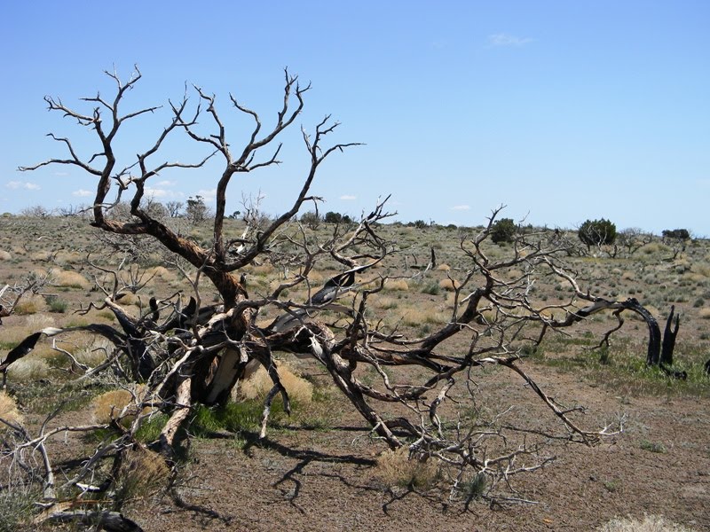 Even more so than when I hiked around Barber Peak, the sight of those dead trees is just heartbreaking. It's hard to imagine how long it will take the pinyon pine and juniper forest to recover. It seems like maybe it will never happen.
Only the far southern edge of the mesa top still had a small patch of forest remaining. Apparently, when this mesa burned, the winds were whipping, as they were as I hiked, strongly out of the south.
 As I made my way across the mesa, I occasionally startled birds. On the return trip, I startled a jack rabbit. It hopped off between the dead trees and headed back to the remaining forested area.
The top of Table Top Mountain is not completely flat, but it is relatively level. It has s slight tilt, with the west side higher than the east side. As a result, at many points you can look and only see either a plain of grasses and flowers, or a skeleton forest, or both. The "horizon" seemed a little truncated, but you can almost forget you're 1,000 feet above the surrounding desert.
 That is, until you reach the edge. There, the ground often drops vertically a dozen or a score feet, then slopes steeply the rest of the way down. The far eastern end of the mesa has a less sudden drop, and is mostly covered in grasses and dead trees. That's why the "easy" way up to the summit is supposed to be from the east.
At the east end, I looked towards (and, I am sure, into) Arizona. From the south, I looked towards Joshua Tree. It was a spectacular view.
 While admiring the view to the south and east, I looked for the trails that I thought would lead to the east side. I saw several things that looked like trail segments, but they might have been washes. I also saw a foursome of large mammals. From my perch at the top of the mountain, I couldn't be sure what they were. I thought maybe desert bighorn. Still can't be sure, but the pictures I shot of them (with the animals blurring and small in the distance) makes me think they were mule deer. A sequence of pictures that illustrate the dimensions of the view from up here is at the end of this post.
 After probably an hour enjoying the solitude, I dithered about which return route to take. My initial inclination was to return via the "sandy flats" route, but I still wasn't sure if I saw the whole trail leading me back. And that route was going to be further, since you start off heading away from the trailhead and need to trace a circuitous route to get back. Instead, I just headed back to west, where I first got to the top of Table Top Mountain.
 Just before I went back over the edge, I located the peak registry. It's just a few small notebooks in a plastic bag and a tin can. The last entry was from January. The one before that was from last October. Don't know how many people summited without finding or writing in the registry, but even if most do not register, that still means this is a pretty rarely-visited summit.
Once off the mountain, I trended towards the southwest, looking for a wash to follow to where I would again slide under the barbed wire and head, due west, back to my car.
Total distance covered is hard to be sure. The Cunninghams say it's a 7 mile hike, but obviously the specific distance must vary depending on which route you take.
The summit is listed as 6,174, making it somewhat taller than Mt. Wilson. The Cunninghams given an altitude of 5,180 for the trailhead, for a net vertical gain of just 1,000 feet. However, 350 of those feet are gained in the last 3/10ths of a mile, and, unless you take the eastern approach, much of the rest of those feet are gained by rock scrambling. It's a hard 1,000 feet, that's for sure.
From my perspective, I don't quite understand why you'd want to take the ridge route on your approach to Table Top Mountain. It seems to me that the going eastward is much faster if you just stayed on the "sandy flats" to the south, rather than navigating the ups and downs of the ridge. However, I say this having traveled only the far eastern end of the ridge route. Perhaps the going along the ridge was not as up and down-y along the rest of the way? Perhaps there is less boulder hopping and climbing involved in making your way up along the ridge from east to west than there is when you are going south to north?
Now, for some fun with deer.
 First, here's a shot from the top of Table Top Mountain, near the east end, looking due south. Twin Buttes is the nearest rise. Woods Mountains are the next rise. Then it's downhill towards I-40, with the mountains on Joshua Tree's northern boundary in the far-off distance.
Now, imagine you've panned your camera down and to the right a little. That's the next picture, below. Match up the rocks to see how we've shifted. Don't be thrown off by the cloud's shadow. I'm not sure if I may have also zoomed in a small amount in one versus the other, but they seem somewhat comparable in scale.
 The deer are actually in there, some-where, but I can't find them, which is not surprising, given the size they would be in this picture. That'll become obvious as we walk through this picture series.
I took this one as soon as I saw the four-legged creatures, running far below. It's probably close to 1,000 feet down, and maybe 300 yards horizontally away. Now take that picture, and crop it so you're left with just the top left 1/4.
 Here's what's left. The deer may or may not be in this picture, but they're definitely not at the same point as in the "original" deer shot, which you'll see somewhat further below. That one was taken several minutes later.
 Next, I took the cropped view above, and cropped it again, to now show just the bottom right quarter of the previous shot. Got it? That's the bottom right quarter of the top left quarter of the original, wide-angle view. That means we've looking at just 1/16th of the original. At least that's true, roughly. I didn't use a ruler to crop.
Now, looking at this 1/16th crop, draw an imaginary line, cutting from left to right, about 1/3 of the way from the top. See that cluster of rocks, just above your line, and near the center?
 Compare them to the cluster of rocks that's at the far upper right corner of the photo here. We'll call this one the "original deer shot." The coloring is off somewhat because it's several minutes later, and the lighting has changed, as well as the zoom. But all the rocks and trees in this "original deer shot" can be matched up to what you can see in that small portion of the 1/16th shot that is itself a small portion of the wide angle view of the deer area. And the deer? One is just left of center, and three more are a bit to his left.
Yeah, that's small. But it's already zoomed about as far as I could go.
 So I took the "original deer shot" and cropped it tighter. That's this last shot, here. The result is a very fuzzy shot, but one where the deer become large enough that their body shapes can be more easily made out. Definitely not cows. :D Probably not desert big horn. Almost certainly mule deer.
Kinda puts the scale of the desert into perspective, doesn't it?


Wow, nice marathon post! Interesting about Google, had to check for myself. Have a good weekend!
ReplyDeleteYeah, I don't know HOW google works, but I do know their returns tend to be a lot more on target than the ones yahoo gives me.
ReplyDeleteI get the feeling they take recentness of a post into account. Sometimes, they get it within minutes, even before I'm finished with my post-blogging editing.
You have a nice weekend, too. I had to look up that acronym on your "Tales from the Trails" blog to figure out what that was about. :D
Thinking of heading up to Crystal Lake tomorrow. Now that the road's open, I'm wondering about the trails that used to head out of there, too.
SkyHiker,
ReplyDeleteI'm writing from the MINI Cooper Wanderlust Team. We've launched a recent effort around celebrating people who get out and get engaged in some kind of high adventure. It's called Wanderlust.
We've been scouting for people doing interesting things like yourself. Your hikes are wonderful examples of the Wanderlust principle. The way it works is people come to our site, tell us their idea for a Wanderlust event, or recount a recent event. If your idea/event is selected you could win prizes or even a new MINI Countryman.
The address for participating is: http://www.minispace.com/en_us/events/wanderlust/create/
There are examples of other Wanderlust events at the site and we imagine if you submitted the community would love your idea (s).
Thanks for listening.
Vince
MINI Wanderlust Team
Hello - I saw your name/link in the summit register when I was on Tabletop in February 2012. It's a great hike - I envy your seeing deer; the only place I saw them in Mojave was in the Mid-Hills Campground. It is a great hike and it is sad to see the fire damage; what a different place the summit (and the campground) would be if all those trees were still alive. There are lots of other great hikes in Mojave, so I hope you head back. Oh, and I had the same problem finding the trailhead that you did - all the mileage information I found was incorrect which seems odd since it's clear that has been the trailhead forever. Did you get a photo of the famous "duck rock"? One of your photos looks like the duck from behind.
ReplyDeleteMike S aka Mr Squishy on arizonahiking.com
Yep, that's the duck rock, alright. It stands out clearer when shot from behind, because if you shoot it from the front, all the rocks behind it are the same color and texture.
ReplyDeleteI got a real rush when I saw the movement way down below, and thought they may have been desert bighorn. It wasn't until I got back home and zoomed into my snap shots that I could tell they were deer.
Once or twice a year I get out to the Mojave to support the Mojave National Preserve Conservancy's star party. The next one is May 20. The Conservancy's website and Facebook page will probably post info on that sometime in the next few months.
Haven't decided I'll try to find another hike or two to take when I'm out there in the spring.
Happy trails!
Hi SkyHiker, our family owns 40 acres at the base of Table Top. Been on many hikes to the top and had lunch with family and friends. What a special place the area is. Too bad we all experience the fire that torn through the area. Sad, I don't think the trees will return either. Sheila Donnelly, Northside of Table Top
ReplyDeleteYour #5 pic is almost to the gate of our property,,,
ReplyDeleteThe fifth one is just off the road. I'm guess your gate would have been along the main road, just a bit over the hill, then. So I guess I was overlooking your ranch from the top. Seems like this would be a heck of a great place to eat lunch!
ReplyDeleteunfortunately a lot of fires in the desert are a lot worse than they used to be, due to invasive cheatgrass, which allows fires to spread much further and faster and more frequently than they otherwise would. It's doing a lot of damage to Joshua trees too. the trees probably will be very slow to grow back if they do at all.
ReplyDeleteI should note that several flooding events have changed the road, and altered the appearance of the "trailhead" over the years. The rest of the hike is pretty much the same, and the mileage on the road should put you near the right starting point, but the description of what you'll see there will be less helpful. For example, I don't remember a cattle grate crossing the road near here, any more.
ReplyDeleteUsed to hike this mtn in the early 2000s. Haven't been back to the Preserve in a couple decades but was thinking about heading back out there again sometime soon. I knew about the fires but didn't know how far they extended. If the Mid Hills fire was the same one that got over to Table Top, I'm shocked. I was saddened to see the photos/report here. That was such an incredible environment at the top. I'd want to check it out again but maybe it would just make me sad like so many places that have gone up in flames over the past 20 years.
ReplyDeleteI don't remember if this was the same fire that burned Mid Hills. I thought the one that burned the campground there was more recent. In any event, yes, hiking between Hole in the Wall and Mid Hills can be discouraging, because of all the burned pinyon-juniper forest that may never come back.
ReplyDelete