 Hiked Sunday, July 31. First hike in the LBL, which I imagine I will become quite familiar with over the coming months.
My first foray into Land Between the Lakes was only partially successful. I should probably splurge for the expensive "recreation map" pf the area, because the trails and trailheads do not appear to be very well signed. I walked around Hematite Lake without once seeing a sign saying that this was, in fact the Hematite Lake trail. Also, this trail should have more or less intersected with the trail that goes around Honker Lake /Bay, but the likely junction was not signed in any way.
 Land Between the Lakes National Recreation Area lies between Kentucky and Barkley Lakes. The former lies behind Kentucky Dam, on the Tennessee River. The latter lies behind Barkley Dam, on the Cumberland River. Both lakes generally stretch north to south, and Kentucky Highway 80 more or less bisects the area from east to west. Within the Land Between the Lakes, "The Trace" is a two-lane road that runs north to south, between I-24 and US 79.
 To get to Hematite Lake, I took KY-80 to The Trace, then took The Trace north about 6.8 miles, to Mulberry Flat Road. It was signed as going to Energy Lake. There weren't any signs for Hematite Lake there.
[Edit--The KY-80 bridge across Kentucky Lake was taken out by a renegade NASA barge a few months ago, so accessing LBL from the west requires a detour to either north or south side of the LBL. (Update -- The bridge has long since been replaced, so ignore. But I'm leaving it here for historical reference)]
I headed east on Mulberry Flat Road for 4.1 miles, to Silver Trail road. There, a sign indicated 1 mile to the left to Hematite Lake.
I initially wanted to take the Honker Lake trail, but saw no signs pointing the way. I think perhaps I needed to follow the sign to The Nature Station, and park there, or outside of that gate. Failing that, I settled on Hematite Lake. I actually walked some around an historic furnace area, but, for simplicity's sake, I'll just describe the Hematite Lake segment.
This trail starts on the far southeast end of Hematite Lake. A trail map is linked here.
The lake gets its name from the former town (since relocated) and the presence of hematite in the soil. The high iron content made the site an important forge location "back in the day."
On the east end, a low earthen impound dam with an earthen and concrete spillway at the southeast end hold back Hematite Lake. Concrete steps allow crossing of the spillway even if the water is flowing, or if the soil here is sodden. If you were to walk the trail in a clockwise direction, you'd cross here, then walk across the clearly mowed top of the dam.
 I actually walked the trail in a counter-clockwise direction. In that direction, the lake starts out shallow and weed-choked, but deeper, open water is visible just fifty yards or so out.
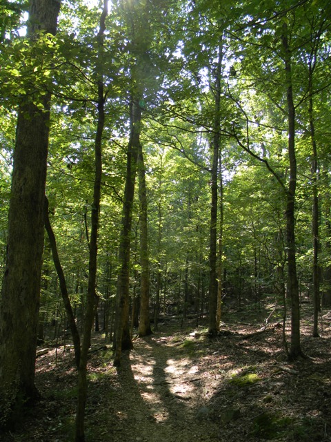 However, the trail soon heads a bit away from the lake shore. Here, the tree canopy is thick. This makes it a relatively cool hike to take when the temperatures are high, but it also obscures your view for much of the way. About a half-mile in, a short spur trail takes you towards the lake, again. However, from the viewing area at the end of the spur, trees still largely obscure the view.
There's also a short detour around a wetlands area near the northwest end of the lake. It adds maybe 1/5 of a mile to the hike (hard to say).
 Once you get to the west end of the lake, the trail spends some time on a boardwalk. This is obviously a wetlands area, and often saturated with water. Water lilies grow thick in this sheltered area. Some were in flower as I walked by.
Atop the boardwalk, I saw the muddy footprints of a raccoon.
 A bridge carried you over a section of lake near what is presumably the inflow for the lake. Another spur trail (seemed to be 1/5 mile each way, at least) headed out to a point. This provided a better view of the water lilies. You could also look back and see the bridge. It wasn't quite Giverny, but it was nice.
 Once back on the trail, the boardwalk continues until you are ready to start heading back east. Then, it's more walking under a forest canopy. You also pass an old pier. One could walk on it, but it looked pretty rickety to me.
Finally, after about a mile of more or less straight walking to the west, you reach the earthen dam and make the final northward jaunt back to the trailhead.


Skyhiker, hope you are transitioning well to your new home!
ReplyDeleteYes, busy cleaning the new apartment and buying basic household stuff. This morning I brewed some coffee. Then I realized I didn't have any cream, sugar, or coffee cups. :D
ReplyDeleteLess time for hiking than I had hoped, though. :(
Hematite town was never reloacted it was destroyed. the easest way to get to honker trail is when leaving hematite turn right you will come to a stop sign turn left follow til you get to a closed road and you will turn right then look for a gravel road on the right and you will find the trail you were seeking.
ReplyDeleteThanks for the local info.
ReplyDeleteI figured out the trail connections later last fall. Honker Lake later became a favorite, because it's a hike of reasonable length with pretty reliable waterfowl and deer spottings in the evening.