Kenneth Hahn State Park (Recreation Area) is located in the Baldwin Hills. It is bounded by La Cienega on the west, La Brea on the east, and (roughly) Rodeo Road on the north and Fairfax/Stocker on the south (it actually doesn't quite reach those roads, but that's the vicinity). To get there, take I-10 (the Santa Monica Freeway). If coming from Downtown, exit at Washington/Fairfax, turn left at the light (Washington), another left almost immediately after that (Fairfax), then another left after about 1/4 mile (La Cienega Blvd).

Meanwhile, last Saturday, my three lanes of traffic were moving fast as I climbed up along La Cienga, into the hills, expecting to reach a left turn pocket to turn into the park. Instead, an offramp suddenly materialized on the right, with a sign indicating that was the way to Kenneth Hahn State Recreation Area.

I followed the road all the way to the end, on up a hill, because that's where the signs for the event I was attending pointed. This was a "Fitness Challenge" event for the entity that employs me, which meant free entry for me (even though it was a weekend), plus the promise of free giveaways and a little Saturday morning hiking. I'm not sure if this road is normally open or not.

The pre-hike warmup was something with very funky music. However, me being me, I did not participate in that part of the festivities. To me, the hike was going to be the warmup. Besides which, the musically assisted stretching would have required that I have a minimal sense of rhythm. I made about three half-hearted steps in time to the music, then gave up. Instead, I enjoyed the view from this hilltop location. The downtown skyline was off to the northeast. This is the opposite direction from what I normally see it.

Instead, when the hike began, we headed due south. A dirt road left from the gathering spot, past a water tower, and pass some powerlines that were very popular with the doves.

Kenny, by the way, was a long-time LA County Supervisor. His son was once mayor of Los Angeles, and his daughter is now a member of Congress, after previously serving on the Los Angeles City Council.

The park is located at the top of Baldwin Hills, which was also once a reservoir. The dam burst in 1963, and the former reservoir was later largely filled in. "The Bowl" is still visible as the outlines of the reservoir, however.

After about 1/2 mile of rolling towards the south, we reached a paved road with a locked gate against La Brea. We then headed up this long (not all that steep, but pretty long) incline. At a level area just over 1/2 way up, we reached an LADWP structure. I guess there's still some groundwater pumping going on in the area, despite the reservoir no longer being there.

Once all the way around The Bowl, another sign was on the south end of the depression. It read, "Janice's Green Valley." I assumed a young Janice Hahn used to enjoy this view.

Finally straggled back to the staging area for the event. It's not that I'm a slow hiker--I was just taking a lot of pictures.
I took even more pictures on the second "advanced" hike. This one seemed perhaps a bit longer than the last one. We started out heading north, around "The Bowl," again. But, at the northwest end of the the depression, a trail peeled off to the right. We continued travelling to the northwest, first near the ridge. There were several pavilions for people to enjoy the view in the shade. I took LOTS of pictures. In particular, I noted that I could see both the Hollywood Sign and Griffith Park, well off to the north-northeast. The whole ridge I had hiked on the previous hike was laid out in the distance.
Closer, to the northwest, was Culver City. On views back to the southwest, I could see the control tower for LAX. This struck me as not a bad place to watch a space shuttle make final approach. Not worth a trip for me, since I feel I have a better viewpoint closer to home. But for folks living out this way, it's a possibility.

The voices were gathered around a waterfall. Yes, clearly not a natural falls. Still, the sound of cascading waters is always soothing.

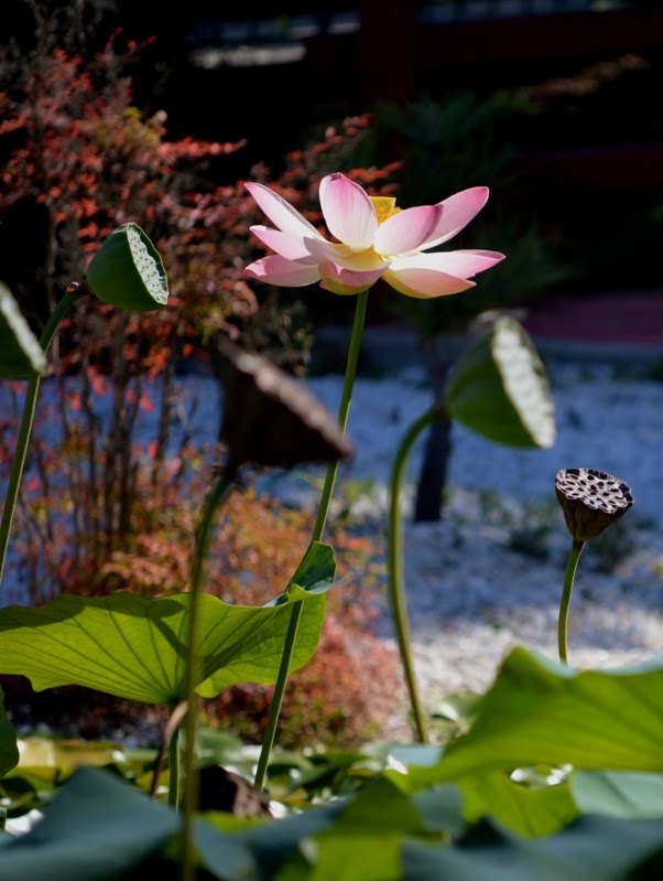
Just south of us was Doris' Japanese Garden. The garden itself is fenced off, but there are pretty views of the small red bridge, the lotus-filled pond, and the smattering of other Japanese influences. Not what you would expect in the Baldwin Hills. I took 18 shots just of the lotus, trying to get it just right. Used the old trick of long zoom and wide aperture to minimize depth of field.
From there, we had at least a long mile, treking across the park, then up the road, back to our starting point.
I'll call it five miles for the day, though both walks seemed longer than 2 1/2 miles. Trail junctions tend not to be signed, though the park is small enough that even a wrong turn should mean nothing more than an extra 1/2 mile or so of walking. Dogs on a leash are permitted.


How do I get the combination lock information to the Kenny Hahn park gate entry on Cloverdale Avenue?
ReplyDelete