Hiked Sunday, February 28. About 5.75 miles. The Antelope Valley California Poppy State Natural Reserve is located near Lancaster. From CA-14, take the Avenue I offramp and head west. After about 11 miles, the road makes two 90 degree turns, one to the left, and one to the right. It also changes name to Lancaster Blvd. About 3 miles after that weave, the Poppy Reserve is on your right.
Peak Poppy bloom is typically in the first few weeks of April, but can vary, depending on how much and when rain fell during the year, if there were any late freezes or early heat waves, etc. In a good year, the hills can be covered by a carpet of orange. In a bad year, there's nearly no poppy to be seen.
I knew I was coming before peak, but I had the time, and the motivation to make a drive out here. Figured I'd check now, and maybe come back in April. But, because it was early season, I knew the trails would be empty and I'd have the trails largely to myself.
And, as expected, there were only a few patches of orange. Not enough rain, and the early warmth / late freeze killed a lot of the poppy plants.
However, even as I walked, I knew the extended forecast had a good chance of rain coming in the next week or two. And, in fact, as I type this (late on Saturday, March 5), there's rain falling on my San Gabriel Valley home. With luck, rain will also fall today and Sunday night / Monday morning, in the Antelope Valley. Heck, with a great deal of luck, maybe some rain will fall in Death Valley!
Anyway, that's just me, telling you that the odds are looking good for a late bloom in the Antelope Valley. It won't be all Poppies, of course. And there's still no guarantee, depending on what happens, next. But I think the odds are looking pretty good.
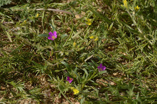
Last week, when I was there, the poppies were, as previously noted, very spotty. The fiddlenecks were much more dense, as were the goldfields. Several nice phacelia patches, too. The predominant color in the hills was still green, however.
I hiked all of the perimeter trails: The lower branch of Poppy Trail South Loop, the upper branch of Poppy Trail North Loop, then the South Antelope Trail South Loop, then the Antelope Butte Trail, then the Lightning Bolt Trail. Nice views from the high points, even without many flowers.
As hoped, the trails were largely clear, and I could shoot without fear of obstructing anyone else's walk or shot.
It was a little hazy, but snow on the San Gabriel and San Bernardino Mountains were easy to see. I could also see Saddleback Butte, off to the east. I hiked out there a few weeks ago.
May try coming back here in two weeks, although I expect that will still be two weeks too early for peak bloom. Sometimes, my visits are dictated more by availability than by conditions on the ground.
Alternate-ly, I may also try to make a visit to Wind River Preserve. I still haven't figured out how visiting that Preserve (run by the same folks who run Oak Glen Preserve and Whitewater Preserve) works. But if I do visit, I'd like to come during wildflower season.
Another alternative would be, if I hear of a bloom in the Mojave, I may go to Whitewater or to Joshua Tree National Park in a few weeks. I think they may need more water than they've gotten so far for a good bloom, too.
As of today, I'm also planning to return to Death Valley next week, too. That's why I'm rooting for a bit more rain there this weekend.
If I do all those other things, and we get good rain the next few weeks, I may aim for the weekends of either April 15, April 22, or April 29 for a return to Antelope Valley. Depends in part, on where the flowers are blooming, and how fast the desert warms up, again, after the current bout of weather.
Previous trips have been drier, with poppies, without poppies, with some poppies, etc. It varies a great deal by year.
A Cold Morning on Chloride Cliffs | Funerals #3
-
I inched toward the edge of the cliff under cover of darkness. My
super-bright, bumper-mounted Diode Dynamics SS5 lights cut multi-mile-long
daggers into t...
2 days ago


No comments:
Post a Comment