Hiked Saturday, March 19. About 7 miles.
I've gotten off to a very slow rate of hiking this year. I'm also still struggling to find the time to blog what hikes I do take. This hike was taken at the end of last week. It was my second visit to Death Valley this spring.
Despite having come mostly for the spring bloom, I have also managed a few hikes over new terrain. Not as many new hikes as if I was not spending a half day or more each trip along the road. The previous blog entry, for example, included a mere 3/4 to one mile, along the road. Very pretty, though. Also, the pictures do not fully convey the feeling of looking over those rolling hills of yellow. It's an amazing sight.
Another slowing factor to my posts is my ancient computer. On days like this, when it's updating, or downloading updates, or running a virus scan, what I type can literally take 20 seconds to appear. It's very frustrating.
My choice of Monarch Canyon was due to having read some wildflower reports from the NPS, which mentioned Monarch Canyon as a place to see a wide variety of flowers. But, though I could see it on my map, an actual description of the trail or hike there was much harder to find.
The best description of the lower canyon section (which, unlike the upper section, is accessible without a four-wheel drive vehicle), was here.
In retrospect, I'm not even sure if the NPS intended to suggest a hike of the lower canyon, or a drive of the upper canyon. Nonetheless, there was a nice selection of flowers in the lower canyon.
My Trails Unlimited / National Geographic map of Death Valley National Park shows a trail that appears to start about a mile east of "Hell's Gate," where the highway that heads into Death Valley from Beatty, NV, and Daylight Pass, splits into a pair of roads, one of which is intended for those heading east on CA-190 (Beatty Cutoff), and those heading west on CA-190 (Daylight Pass Road). You take the Beatty Cutoff Road from Beatty. If coming from Beatty, you take the cutoff east, and the mountains are to your left. Monarch Canyon is the most obvious opening in those mountains.
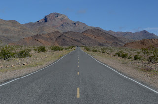
If there's still an actual trail to this canyon, it's trailhead is very non-obvious from the road. I just picked a spot where my eyeball suggested I was at the same altitude as the mouth of the canyon. That left me more or less on a line between the mouth of Monarch Canyon and the distant Death Valley Buttes, pictured, above.
My plan was to use the buttes as an obvious marcker for getting back to my car. Didn't exactly work flawlessly. And I felt bad, walking over ground that had wildflowers, trying to grow before it got too hot.
Despite feeling like I was walking randomly, I actually did come across a wooden marker that was pictured on the other trail write-up I had come across. And, after that marker, I could see a trace of an old road that I could follow. Didn't manage to find that road on the return walk, though.
The descriptions I read gave a distance of three miles to the waterfall at the canyon's end, with about half that distance being the walk across the relative flat of the alluvial fan to get to the canyon mouth. In real life, however, I felt as thoough, distance-wise, it was more like 2/3 of the distance was spent on the flats. Much of that was just cross-country.
Numerous washes came down off the mountains. I continued heading east, looking for the largest wash, which I figured would head back into Monarch Canyon. Finally found that one.
The wildflowers became more common once in a wash.
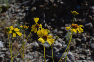
The wild-flowers pictured in this post are, in order: desert primrose, brittle-bush, Bigelow's Monkey flower, lessor mojavea, brown-eyed evening primrose, and pebble pincushion. I also saw a few desert five spot, but they were closed, and not that photogenic. A few other flowers that I did not photograph, as well.
Once in the canyon, I came across a few spots with small puddles of water. It had clearly rained a bit, the night before, even in Death Valley (it had poured on me in Beatty).
This canyon, like many in the area, had very twisted rocks. Just a few narrow points before the wall where the water fell. It was mostly comfortably broad, and not claustrophobic.
The waterfall is described as perennial. Still, the flow was not that high, despite this being winter, and with the heavy rain the night before. Probably more magical in the summer time, when it's crazy hot.
This was still. la very nice hike. For starters, it was mostly just me and the canyon. There was one couple heading up canyon as I neared the mouth on the way out. There were a few other cars parked along the road where the owner was not obviously just walking along the road, taking pictures of wildflowers (though, when I left, there were plenty of those, too). And I'm pretty sure that, if they had headed in or back out of Monarch while I was heading in or out, I'd have seen them (It's a pretty unobstructed view on the slope heading towards the mountains).
So whether the other car owners went up some other canyon, or just left their car there and road off with someone else's car for a while, I don't know. But I didn't see them during my walk to and from Monarch Canyon.
By the time I got back to my car, I was ready to go home. Just seeing the crowded parking areas at the more popular trailheads and parking areas deterred me from making an additional short walk. Well, I should say, it made it easier. I was tired enough to call it a day, and the full parking lots just reinforced that inclination.
It's probably a record visitation year for Death Valley National Park.
I have one more trip planned for the park, in early April. So, I shall return. I'm hoping to get at least one decent hike out of that trip, but I'm mostly going for the astronomy outreach. That's assuming they get back to me with additional information, as I have requested. "Marsfest" is April 8-10.
A Cold Morning on Chloride Cliffs | Funerals #3
-
I inched toward the edge of the cliff under cover of darkness. My
super-bright, bumper-mounted Diode Dynamics SS5 lights cut multi-mile-long
daggers into t...
2 days ago


No comments:
Post a Comment