
A long time ago, I hiked the Calico Hills trail from the start, when fall wildflowers carpeted the area. I wondered if, following a wet spring, we might get a similar show?
Alas, the answer appears to be, "No." I mean, there were certainly some wildflowers, and likely more blooms still to come this spring, but they were not dense as that long-ago fall day.

The Calico Hills trail starts near the entrance station. From the visitor center parking lot, you need to head downhill, and, from the lowest lot, find the trail signage heading yet further down, towards the aforementioned entrance station. Once there, you cross the street, and make your way a bit further west, before heading back north, parallel to the road.

Nonetheless, the route had some promise, for me. Although much of it parallels pavement, you're not right near the road, and only a fraction of visitors to the area ever walk the lower reaches of this trail.
Of course, even on crowded trails, usually you manage to leave a pretty good proportion of the crowd after a mile or so. However, because you're often hiking narrow canyons or climbing relatively narrow chutes, even relatively few people can still produce bottlenecks. For this day, that would only be an issue further along, on the Calico Tanks part of this trail. For the Calico Hills trail, once away from various trailheads, it was, as expected, pretty empty.

It's not wilderness, obviously, and, in fact, the climax of the hike is a view back into the Las Vegas Valley. However, you do get plenty of time to listen to the wind and be lost in your own thoughts.
On my previous trip on this trail, I inadvertantly diverged from the actual Calico Hills trail, right around Calico II, and wound up within the Calico Hills, themselves. That's not entirely my fault, as there are lots of use trails around here, and even the signage can be a little confusing. In one case, as I approached a sign, a bright arrow pointed one way, but an arrow in shadow was not apparent, and I turned the wrong way. They good news is that I got to see a Mojave aster bush in bloom. Then I backtracked and fixed my mistake.

By not losing the trail, this time, I was brought pass a few stained rock slabs with a few faint pictoglyphs (pecked out of the rock, rather than painted on the rock). I had to increase the contrast of the photos, after the fact, to make the pictoglyphs more apparent.
Just prior to that, I heard the scraping of a small chuckwalla over sandstone. I peeked over a ledge, to snap a picture of him.

That's this picture, here.
I also snapped a picture of some of the weirdly eroded sandstone. This one looks like a grumpy old man, yelling, "Get off my lawn," with a uvula and everything.

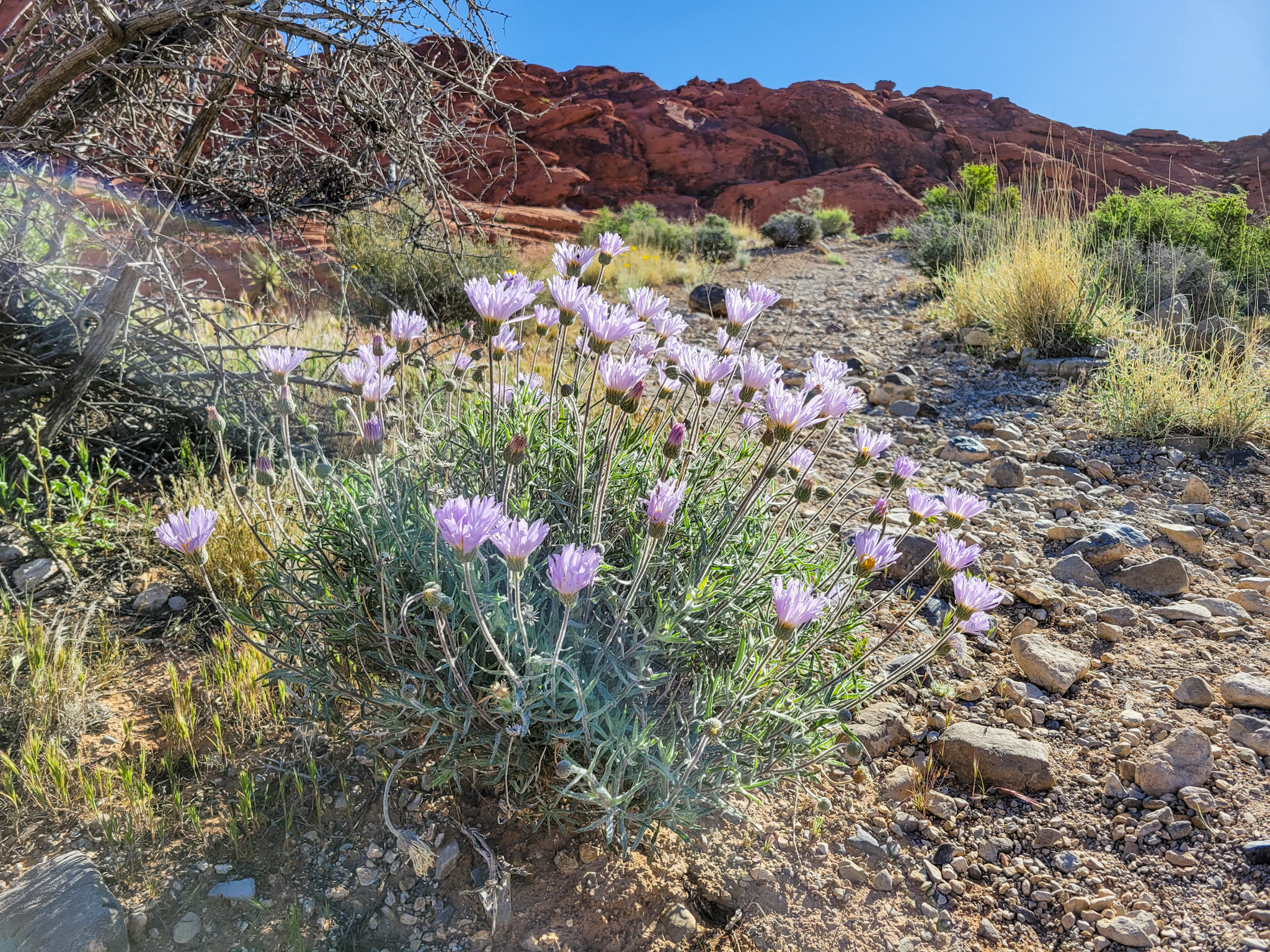
Among the wildflowers I did see, were desert marigold (pictured at the top of this post), which was probably the most common. I saw a few blooming beavertail cactus (the second flower shot in this post), with many more on the way, and quite a lot of globe mallow (not pictured), again, with many more buds, indicating more blooms were on the way.

I also saw a few mariposa lily, as pictured, here, and a few bushes of mojave aster (the next shot).
Finally, I saw one patch of what may have been fleabane, and once I got on the Calico Tank trail, several really prolific red bud trees. Everything else pictured was on the Calico Hills trail.
Once on the Calico Tank trail, it got more crowded, and there were more times when I had to step to the side, or others had to step aside, to allow hikers traveling in the opposite direction to pass. There were also a few times I did not take the right route up. One made me do a short lift to get back over to the trail. Not particularly dangerous, but clearly not what would be on the designated path for a trail like this.

Once the trail starts on its southernly leg, the climbing gets steeper, so even though it's only supposed to be 1.1 miles from the parking area to the tank, the last 1/2 mile feels longer. Well, it was also after I had already walked about four miles, so even more so. I dragged in places, and huffed and puffed a lot.

The tank itself is just a small natural pond, where runoff is trapped, providing water for desert residents through much of the summer, depending on how wet the winter and spring was.
The official trail stops at the tank. But going to the other side provides nice views towards the Las Vegas Valley. From the north side, you have the option of either walking just a bit above above the west "shoreline," with the a small potential for an unpleasant and bumpy slide into the lake (not as likely with grippy shoes), or taking a higher route, further to the right, with no exposure to a fall. Not remembering for certain at the time, I took the low route out, and returned via the high route.

Once on the other side, a modicum of balance and you can get to one of a number of nice views to the south and east. The tank photo in this post is from the opposite side, looking north.
I then picked my way around a bit. But, knowing my legs were already becoming a little wobbly from exertion, I did not attempt too many options. Obviously, had I only walked from the nearest trailhead, this wouldn't have been an issue. Also, if I were in better shape. But this was my first significant hike (more than 3-5 miles) in a really long time.

The funny part (to me) was, after making my way up a nearby boulder, I semi-froze on the way back down. That's because the way up required me to lose one point of contact with the ground, pulling up with my arms, with one leg pushing up a narrow ledge. Naturally, that means the decent required this in reverse, losing one point of contact, and having to drop below the point of no return to land a foot on the "surface." And the tricky part is, when you're going down, you can't easily see your toe holds, or how far you'll have to drop to make ground contact.

So, in this case, I kept readjusting my toeholds and hand holds, trying to minimize the drop down to the "surface." The slope was such that, if I miscalculated, my foot might land on a sloping surface, then I might slide and flop on my butt, or worse. I could also have just made a hop down, but, again, a slip, and I'm sliding or tumbling. Small chance of that, but bad outcome if it happens.
After about five adjustments, and me trying to decide if it was safer to just make a longer hop down where I could see where I was going to land, and control the direction of my landing or fall, I finally committed myself to easing myself down as far as I could, then took the blind drop down to the surface. Turned out the drop was about ten inches! Seemed like it would be longer than that from above. I was happily relieved. Yeah, I'm really bad at judging heights from above!

Occasionally sloppy with my footwork, but no significant problems heading back down Calico Tank trail. Once back at the parking lot for Calico Tank/Turtlehead Peak, I observed numerous rock climbers on the cliffs, now to my left. I continued seeing them pretty much the entire way where the Calico Hills were adjacent to the Calico Hills trail, both higher up on the cliffs, and on some of the rock faces at the bottom of the canyon, right above the wash.

This is in addition the regular rock scambling-types, who don't use technical gear. The rock climbers I'm talking about had ropes, a means to anchor those ropes, helmets, the works. Since I'm too chicken to do such a thing myself, I have not checked in terms of whether climbers are using existing anchors, or restricted to using what's already there. But there were quite a lot of them.

I had seen them on previous trips, but it seemed like there were more, today. Also, I had often seen them along the escarpment. Or, more accurately, I saw their lights on the escarpment, after dark, while I snapped Milky Way shots.
I have also often seen the helmeted climbers walking back towards the trailheads on that side of the scenic drive.

I semi-inadvertantly left the Calico Hills trail during my return, as I neared Calico I. I figured I had approached Calico I at road level, but I could see some very well-defined trails down below, and thought those might also link back up with the Calico Hills trail.
So I explored, which is not objectively a bad thing. In this case, though, it did add a little distance and a lot of climbing and decending and climbing to eventually get back on the Calico Hills trail. But you only learn for sure if you walk the steps, which I did.

There are also linkages between the lower part of the Calico Hills trail and trails on the Calico Basin side of the national conservation area. But that would have added a non-trivial additional distance, which I wasn't prepared to walk. So, instead, once it became clear how long this detour would take, I took a cross-country route out of the canyon and back up to where the Calico Hills trail was.

Near the end, I had another choice, of whether to return the way I had come, or take the "Grand Circle" trail back to the visitor center. Even though I've done both trails before, it was long enough ago that I wasn't sure which would be faster. Because the Calico Hills trail went all the way back down to near the entrance station, I felt like the Grand Circle trail would be shorter. But that trail takes a roundabout way around the visitor center, and you wind up approaching it from the southwest, so I'm not sure which way would have been quicker to my car.

On the other hand, I had, for a while, the idea that I would want to pop into the visitor center/gift shop, just to see what's what. So walking toward the visitor center rather than my car seemed the more appropriate route. However, by the time I did get to the visitor center, no, I was ready to go home.

As indicated on the screenshot of my Alltrails recording, I walked just under ten miles for the day, with about 1575 feet of gross vertical elevation gain. I was pretty beat. First decent distance of continuous walking in a while. Good to know, before I make overly ambitious plans for additional hiking this spring and summer!


No comments:
Post a Comment