Sunday, March 24, 2013

Hike 2013.014 -- Sloan Canyon National Conservation Area, Trails 100 and 200

(Volcanic plug and yellow flower).

[Edit--Note that recent construction in the Inspirada development has changed access to Sloan Canyon. Use the information in this linked post, along with what is written below, for more recent directions to the trailhead].

Hiked Saturday, March 23.

This is the petroglyph hike. It should go without saying (but I'll say it, anyway): DO NOT TOUCH THE PETROGLYPHS. You shouldn't go crawling on those rocks, at all. It's ancient art, and you wouldn't go crawling all over an art museum, would you? In particular, the oils in your hands may speed the erosion of the desert varnish that makes these petroglyphs possible.

I tried to find this trail way back on February 16, as my Hike 2013.008. However, the directions in the book I was using were pretty useless ; it told me to drive "several miles" along a rough dirt road, looking for a power line pole with a number that was in an entirely different format from the ones in the field.
(Looking north from the "parking lot." The concrete wash passes beneath this spot. A large detention basin is behind the concrete structure in the distance).

The BLM also gives directions to this trailhead. My suggestion would be to ignore those directions, unless you just happen to have a high-clearance 4-wheel drive vehicle and you want to test its capabilities for longer and farther than necessary. Instead, I more or less followed this route, one of many places where an alternate, north or east approach (as opposed to the BLM's west approach) is described.

(Looking west from the "parking lot." You start by walking along the service road, which is just to the left of this row of transmission towers).

From St. Rose Parkway (NV-146), head south on Executive Airport Drive. There's a light there. It's about 2 1/2 miles northeast of I-15, and about 2 miles northeast of Las Vegas Blvd. It's also about 1 1/2 miles southwest of Eastern Avenue. After about 1 1/2 miles, you'll pass Volunteer Blvd, where there's a traffic signal. Continue south. Executive Airport Drive is now Via Inspirada. After another 1 1/2 mile or so, the speed limit drops to 15mph, and the road makes a sharp left-turn, and is now Bicentennial Parkway.

(Looking nouth from the "parking lot." The dirt road I took to get here runs just right of the concrete wash you see in front of you).

Hopefully, there's no one following you, because you'll need to slow down and get ready to pull off the pavement, on your right. As soon as you pass over a wash, that's your turn.

(The small sign at the beginning of the Sloan Canyon Access Road, which intersects with the service road, just 1/4 mile west of where you started).

This is NOT Via Contessa. On Google Maps, this is shown as a dirt road just east of Via Contessa, and runs parallel to and just east of the concrete wash. The dirt road parallels the wash for about 200 feet before making a sweeping left turn. You head that way a bit more than 1000 feet before turning south, again. It drops into a small gully as it does so.

(Boundary of Sloan Canyon National Conservation Area).

This is the only area of the dirt road where you'd need to slow to a crawl. Anything without an exceptionally long wheelbase or low clearance should be able to make it through. The rest of the dirt road is otherwise very flat, and cruising along at 25 - 30 mph seemed pretty safe.
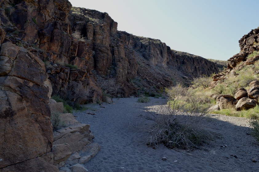
(High wall on the east side of Sloan Canyon, somewhat after passing the first junction with Trail 200, but before the second barrier).

After clearing the gully, you climb up the other side, then begin a turn to the left, back along the concrete wash. Parallel it for about 1600 feet, then slow and make a right. Exactly where the road crosses the wash is a spot that seems to be a good parking spot, at least if you're in a sedan. Don't block any of the gates, of course.

(Petroglyph of desert bighorn, which seems to appear in every desert petroglyph grouping I've ever visited).

People with high clearance vehicles can continue on, making a slight right for an easier approach up the very slight incline, then a left, then another right. The road is rougher there, but, at least when I went, it would not be an issue for 2-wheel drive, high-clearance vehicles.

(Extra-terrestrial humanoid?)

Whether driving or walking, you'll need to head west about 1/4 mile, paralleling the brown towers that hold high voltage transmission wires.

(Rubber-armed humanoid or gecko).

After 1/4 mile (and just before you'd reach the powerline with the alleged 2084 number on it), there was a stake with a small sign that indicated the way to Sloan Canyon. This is labeled Sloan Canyon Access Road on Google Maps. If you look towards where this road heads, you'll see it's the first narrow canyon you encounter from the east. This canyon broadens before you, and drops down to join the broad wash that empties into the the detention basin that's just a little upstream of where you (or, at least, I) parked.

(Millipede and gecko or stick human figure).

Follow Sloan Canyon Access Road to the north. You'll pass a sign announcing the boundary to Sloan Canyon National Conservation Area in about 1/2 mile. After another 1/2 mile, you'll reach a very small parking area, and a fence that would keep you from driving any further.


(More rocks with desert varnish, and some petroglyphs).

During my walk from the wash to the parking area, two pickup trucks passed me. On the way out, one ATV and one SUV came in. It's unlikely that anyone else visited the site during the 3 hours or so I was walking in the area, and this was on a Saturday (albeit a March Madness Saturday, so maybe everyone was watching basketball). ;D

(Yellow flowers. Saw a lot of these guys. The flower looks like a poppy, but the plant leaves do not).

The display at the trail head is probably not going to tell you anything you don't already know. There's also a place to sign in, so if you plan on getting lost, be sure to sign in so they'll know where to look for you.

From the parking trail head, continue up the main wash. This is Trail 100. It's the base of a wash, so the going may be a bit slower than you were enjoying on the dirt road. The canyon walls that began narrowing along your walk up to the canyon mouth get even narrower and taller as the wash winds through the canyon.

(Fiddleneck).

Three-quarters of a mile after the the trail started, there was a stake in the middle of the wash. To the left was the continuation of Trail 100. To the right was labeled Trail 200. Since Trail 100 sounded like the main way to me, and that way was clearly wider, and the hikers in front of me went that way, I went that way, too.

(Small purple flowers--couldn't id them, either).

Trail 100 was smooth and flat for the next 1/4 mile or so. Then there's a 1/4 segment with a series of "barriers," places where you could not just walk up the sandy wash bottom. The first one had a very obvious trail that headed along the left side of the wash, and was an easy walk up. The second one didn't even leave an impression on me, so I'm assuming it was also a walk-up. The third one, however, is Class 3. It's not a particularly difficult Class 3, and it's a very short segment--one short climb, where you'll either need enough upper body strength to pull yourself up, or someone giving you a boost to your foot to get over some very slick rock.

(Globe mallow).

The description I linked above says you should go up the middle of the barrier, where if you fall, you'll just land on the sand. However, I think most people go up the left side, where there's a lot more rock to grab on to.

After the third barrier, the trail bends to the left and widens, again. The left side is steeper and has a sort of onion peel vibe to it. The right side has large volcanic blocks with lots of desert varnish, and that's where the petroglyphs are located.

(Looking southeast from near the north end of Trail 200. Orange are mallow. Yellows are those poppy-looking flowers).

The petroglyphs continue for another 1/10th to 1/8th of a mile, thicker in some places than others. I stayed on the wash floor because I didn't want to damage the ancient rock art. This is suggested for all.

After the petroglypths petered out, I continued exploring a bit further. Coming around a bend, I saw a huge, tall volcanic plug in the distance. Very cool.

Within an additional 1/8th of mile, I encountered another stake in the ground. This one pointed me in three directions: Trail 100 was the way I came, Trail 200 (also labeled "Cowboy Trail" on Google Maps) was up and to the right, and Trail 300 was straight ahead.

(More fiddleneck).

Since I already knew that Trail 200 intersected with Trail 100 in the direction I had just come from, I went up towards Trail 200. This area had a nice little patch of color. Desert poppies were blooming relatively thickly (for this area, I would presume). Desert mallow were mixed in, as were tiny purple flowers I need to learn the name of.

(Mix of purple and yellow flowers, previously pictured up-close).

This path climbed somewhat steeply and took me a little bit closer (but not very close) to the volcanic plug. Then, before I knew it, I popped over the ridge. Gusty winds, which were almost non-existent while in the canyon, hit me face-on. The Las Vegas Valley stretched out in the distance ahead of me. My trail, meanwhile, switchbacked quickly below me.

Definitely no more than 1/2 mile from the crest back to Trail 100, then on back to my car.
(Volcanic plug, up close).

Just about 2 miles walking on the Trail 100 and 200 loop. Just under 2 miles roundtrip walking the Sloan Canyon Access Road. Just about 1/2 mile roundtrip on the powerline service road. Call it 4.5 miles total for the day. Had I not wanted to take my car off-pavement, that would have added between 1 and 2.5 miles of walking, depending on where I decided to park, and on if my route was not blocked.

(Looking north from top of Trail 200, preparing to descend towards Trail 100. Henderson and Las Vegas in the distance).

My driving route was open, unfenced, and not posted "No Trespassing" as of March 23, 2013. No way to know if or when that might change. In the past, population growth and construction was so rapid in the Las Vegas valley that even road directions would often become obsolete within a matter of months. It's in a bit of a lull at the moment, but that may change. I know the long-range plan is that the City of Henderson will build access roads and trails to get into Sloan Canyon NCA. But, again, no way to know when that might happen.

Can't find my Joshua Tree wildflower fold-out, which might have helped id some of these flowers. If I figure out what they are, I'll go back and label them.

Thursday, March 21, 2013

Some amazing wildflower photos

Came across this post on the blog, Avoiding Regret. Definitely worth a gander.

Saturday, March 16, 2013

Hike 2013.013 -- Eaton Canyon


Hiked Saturday, March 16.

Things keep coming up to keep me from getting my hiking in. Of course, a lot of these things are good; they just keep me off the trail.

Today, I had only a few hours in the morning to hike because I needed to be back for an appraiser to look at the house. So rather than a drive out to Joshua Tree for some hiking and comet hunting, I needed to do something short. I was still thinking of maybe heading out to the desert in the afternoon, but I'm feeling tired enough now that I'm not even going to make it into the Angeles National Forest for comet hunting, I think. Might do some sidewalk astronomy in Monrovia, though.


At any rate, it was approaching 9a by the time I made it to Eaton Canyon. It's the closest San Gabriel Mountains trailhead from my house, but one I had not been to so far this year.

Settled on a waterfall hike.

Parked on the curbside, Altadena Drive, just north of New York Drive. I figure that adds about 1/2 mile roundtrip to the hike.

They have planted sunflowers along Altadena Drive, and also in the area just north of the visitor center. In both locations, they are blooming like crazy right now.

I snapped a few pictures, then headed down on the trail (which starts just south of the drive way), crossed the driveway, and continued on the trail that stays "behind" the visitor center and west of the parking area. You join the main trail just north of the developed area, near where several nature trails loop in the area west of the visitor center.

Once I emerged on the main trail, I saw the first of what must be a crowd of hundreds. Still had the occasional moment to contemplate nature, but it was very crowded.

The fog burned off quickly, and by the time I reached the wash crossing, the mountains were now easily visible. The ground here was wet, but no water ran. I remember one year, the water ran high and fast here, and the crossing had to be made along a downed tree, well upstream from here. No such problems today.


As I walked on the straight section of the trail that stays east of the wash, I saw the water did not appear on my left until maybe 1/4 mile of the bridge. Still further along than earlier in the winter, but clear evidence that the waterfall would not be running especially high.

Once in Eaton Canyon proper, there are numerous stream crossings. When it's crowded, those stream crossings become bottlenecks. That slowed me somewhat, but it was not an obnoxiously slow way up. And, again, there were moments of solitude, when I could snap a few pictures in the absence of voices not my own.


Upon reaching the falls, however, there could be no illusion of solitude. I count about 35 bodies in several of my pictures of the end, and that's without being able to see into that final bowl where the water falls. Can't quite see the edges of the base area, either. I would expect well over 50 people where there.

So I snapped my pictures from a distance. No need to walk any further; it wasn't going to get better. Then I headed back. Again, a few bottle necks, but also lots of my time to get to my regular pace and try to burn some calories.

I'll call it 4.5 miles for the day. Still enjoyable, if not far too crowded for my taste, but hardly surprising, given it was a weekend morning with excellent weather.

Still have two hikes to write-up. May or may not be able to do that before my next hike. That one won't be until at least Thursday, since I have evening commitments Monday through Wednesday, and I work all day tomorrow.

Friday, March 15, 2013

Hike 2012.012 --- Rubio Canyon and Bailey Canyon


Gotta keep these short, because I'm just falling too far behind in my blogging.

Hiked Saturday, March 9. I actually hiked Rubio Canyon as my 11th hike of the year, as well. I returned after a night of very heavy rains, thinking the falls might be more active this day.

First, I headed to Bailey Canyon. That's north of Carter Avenue, just west of Lima. I've described getting here in the past. Search here or google elsewhere.

Bottom line: Still just a moist drip on a wall. I was really expecting a better flow after all that rain, but I guess it still hasn't made up for the dry winter.


Next, further west, to Rubio Canyon. I finally figured out the least-turns way to get here. Take Altadena Drive north. After Eaton Canyon, and vicinityh, Altadena Drive becomes an east-west running street.

Right after the first stop sign past Eaton Canyon (Allen Avenue), take the next right (Tanoble Drive). It's a narrow, residential street, so drive appropriately.

Turn left at the stop sign. That'll be Loma Alta.

There are several deep dips in this road, so, again, drive slowly, especially when you approach the signed dips.

Your road will turn to the right, with a concrete detention basin on your left. When it makes a sweeping turn to the left, the road changes name to Rubio Canyon Drive.


Right where the change from Loma Alta to Rubio Canyon occurs, there's a small road that heads north. Google Maps says it's Camp Huntington Drive, but there is no name on the ground.

You can't park on that road, nor on the adjacent Loma Alta or Rubio Canyon Roads. Instead, continue another 100 yards, to Rubio Crst Drive. Turn right and park there. Then walk back to your trailhead.

Or, if you want to get the falls and have a shorter, less-steep hike, drive on up to Rubio Crest. Turn right at the corner (Rubio Vista Drive), then look to park when Rubio Vista parking when your road makes a 90-degree left turn and changes name to Pleasant Ridge Drive. There's a trailhead between the two houses on the hill-side of that corner.


From the trailhead I took, it adds probabably 2/3 of a mile roundtrip to the hike, and probably 120 or so of vertical feet.

I've blogged on this hike before, so nothing to add.

Waterfalls were still low here, too. Didn't bother with the higher falls. Just headed back after the first two.

A few wildflowers were blooming. The Western Wallflowers I saw last week were still there. Also photographed mountain lilac, wishbone, and the first lupine I have seen in a while.

Short three miles for the day, between the two hikes.

Thursday, March 14, 2013

Comet PanSTARRS


Still way behind on writing up my hikes. On Tuesday, I drove up the Angeles Crest Highway and viewed comet PanSTARRS from the side of the road. Looked great in binoculars and with a telescope. But I forgot my camera.

Yesterday, around 7:30pm -8:15pm, I stood out on my west-facing balcony and took a whole bunch of pictures of PanSTARRS. Here's one of them. My DSLR is zoomed in to 200mm. Tried a bunch of shots at various ISO and shutter speeds. Basically, about ISO 800 and 1/4 second seemed to work pretty well.

I'll try to get back to my hiking blogging before the end of the weekend!

Thursday, March 7, 2013

Hike 2013.007 -- La Tuna Canyon Park, Verdugo Mountains


Hiked Saturday, February 9. Yeah, I'm still way behind on my hike write-ups, and not even going in order, any more. I guess the one good part about not being able to manage any hikes the last week is that I'm not falling any further behind in my blog write-ups.

This hike, now almost a month ago, grew out of my reading a post from Hiker Dan on his visit to the Verdugos, and it got me thinking about coming to this area. Never hiked here before, which is slightly surprising. It's not far from home (didn't time it), and it turns out I've driven by them often, but usually very quickly, in the Foothill Freeway, while shooting off towards Mt. Pinos or other points north.


I had also overlooked them on my recent hike to Mt. Lukens and the Deukmejian Wilderness Park, above Glendale. That was another first-time visit, by the way.

But where to hike? So I pulled out my Tom Harrison Angeles National Forest Front Range map. It's a pretty large scale, especially for the Verdugo Mountains. But I could see that there was a trail that started off of La Tuna Canyon Road. Since I recognized that road from my travels on the 210, I figured that would be an easy place to find.


Unfortunately, I can't find that map now, as I do my write-up, so I can't give mileages. However, I did find this map on line, and I'm sure that the place I started from is marked "The Grotto" on this map." By this map, and the signs at the trailhead, I deduce that I was in La Tuna Canyon Park, one of many managed by the Santa Monica Mountains Conservancy.


According to this map, it's 3/4 of a mile "south" (or west) of the Foothill Freeway (I-210). Exit at La Tuna Canyon (just a few miles west of the Glendale Freeway, CA-2, which, at this point, is NOT the Angeles Crest Highway!). I went under the freeway and headed south. Immediately after the freeway is a large parking area on the left. But I knew that wasn't the one I wanted. I continued a mile or so past that and saw another parking area, which didn't look like the one I wanted. Then, maybe 1/2 mile after that, was another parking area, which was the one I wanted. But I was already past it by the time I figured this out. There were plenty of cars there, too.

When it was safe, I pulled over, then made a U-turn and headed back north. I opted for the
empty parking area, on the assumption they would all link up someplace up the hill, anyway.


My trail dropped into a deep gully, where many tires and found their final resting place. Heading west, the trail was well-defined, though narrow. It headed into a ravine. After about 1/5 of a mile, it got steep, then reached a dead end at a drop that would probably be a very pretty waterfall if water were falling. Today, it was only seeping. And this was just a few days after a fair rain, with light snow falling higher up in the Verdugos.

I backtracked, and soon found what looked like a use trail that headed east, out of the ravine. After 100 yards and a bit of steeply eroded scrambling, I was on an improved, clear, but still narrow, trail. This one headed into the hills, as I expected. On the opposite canyon, I could see another trail, which I would later learn leads (after many twists) to the parking lot south of the one I was parked at.


Meanwhile, the trail I was on became clearer, and it was obviously an engineered trail, with rock and wooden supports in spots. I enjoyed expansive views to the west. Eventually, I made it to a ridge, and could see clear to the north and east, as well.

This trail ran along a ridge, finally reaching a dirt road (Verdugo Motorway, or Verdugo Mountains Fire Road) after what felt like several miles. Once on the dirt road, I made a left, as that seemed to be up. I soon passed adjacent to a plantation for trees. Several clearings and benches were also up here near the top ridgeline, as were a lot of radio and microwave antenna.


I continued along the ridgeway far enough to get a clear view over into the San Fernando Valley. To the southeast was downtown Los Angeles, which lay beyond the L.A. River. I could also see Silver Lake. To the right of Silver Lake was Griffith Park. Next was Forest Lawn.

Closer to me was a golf course, and a whole lot of other roads up into the Verdugo. Here, and later in my hike, I realized that the Verdugos have some pretty steep drop-offs.


In the meantime, I needed to start heading back. Because I didn't want to repeat the up and downs of my way up here, I was leaning towards trying to get back via what I assumed to be a wider, more traveled, and less steep alternative. Given the lay of the land, I was pretty confident I could navigate my way back to where I started via a different route.

Thus, I headed down the motorway, assuming it would lead me to the larger parking area I had seen off of La Tuna Canyon.

I had barely started my way down before I saw my first and only significant wildlife of the trip. It was several hundred yards away, but I am pretty confident it was a coyote.

(There's a coyote in there)

Unfortunately, I didn't have time to switch to my telephoto lens. So I shot with wide-angle telephoto at 55mm. At full-size, the coyote is pretty invisible. At a crop, the creature is pretty fuzzy. Odd thing is the white tuffs at the end of his ears. Almost feline that way.

Wish I could have gotten a better shot.

I continued down the road. Several mileage markers were along the road, but it was not clear from my return what they were measuring distance to. In looking at my map, I'm pretty sure it would be Wildwood Canyon Park.
(Coyote, cropped, closer).
Regardless, long before I got to the end, I saw a side trail, heading to the west. It seemed to be a more direct route towards where I knew my car was, so I went that way.

This trail gave away altitude rapidly, which meant that if I was wrong, this was going to be a heck of a long way back.


The good news is that the trail dropped right into the drainage I thought it would. It even came as close as 100 yards of the trail that ended at the dry waterfall. However, there was no easy way to cross that gap, so I wound up following the trail to what I later deduced to be the "main" La Tuna Canyon park and trailhead area. It was a winding way to get there.

It also left me about 1/4 mile down La Tuna Canyon Road from where my car was located. Not too big of a problem, of course.

I'm estimating about five miles for the roundtrip distance, though with a pretty large margin of error.

Monday, March 4, 2013

Hike 2013.005 -- Las Vegas Springs Preserve


Hiked Sunday, February 3. 3 miles.

Not much to say about this one. But I'm so far behind in writing up hikes, that doing a short and easy one now seems to make sense.

Las Vegas Springs Preserve is located where Las Vegas was born. You may or may not already know that "Las Vegas" is Spanish for "The Meadows." The Meadows were a grassland where the Las Vegas Springs bubbled to the surface, providing reliable water that made this a stop-over point for trains in need of water.


Those springs have long ago dried up, or, at least, no longer bubble to the surface. But the Las Vegas Valley Water District apparently got it in its head to do some image polishing by sponsoring this Preserve. They've built a large number of buildings, a garden, a small zoo, a flash-flood room, a museum (not to be confused with the adjacent Nevada State Museum), an artificial wetlands, and even left some of the land in its semi-natural state. If you know much about land management history, think of the National Park Service, circa 1920-1940, when they were blasting roads across the granite surrounding Tenaya Lake, dumping burning embers over Glacier Point, and plotting aerial tramways into the Grand Canyon.


In short there was a lot more going on at the Las Vegas Preserve than I expected to find. Some of it makes sense, but some of it just seems like overkill.

I didn't check to see what I was getting into when I planned my visit. I thought I would just have a nice little trail to walk around the historic wetlands, and maybe get a peek at some birds, flowers, or what ever might be poking around the creosote bushes. That sort of shows what I was focusing on during my research: "Are there trails?" was all I wanted to know.


So I did take a walk around the preserve, as well as the museum. There are many historic sites here, though I suspect some of the archaeological evidence has been bulldozed under the massive building project that has come here. Birds do visit the Preserve, still, and there's still some open space. However, the main trail is paved, and you can rent a bike to peddle around it.

That's not a problem. But if you come later, there's now a "train" that takes visitors around the pavement. No, there aren't any rails. It's not a real train. But it does blow a mean whistle at regular intervals.

Side trails that are not paved are reserved for people on foot.


If you come by early enough, you can enjoy a fair amount of peace. Especially on weekends, however, this place gets hammered. And loud.

To get here, you'd take US 95 north (west), about two miles past Downtown Las Vegas' "Spaghetti Bowl" (the US 95/I-15 Interchange). Exit at Valley View, head south, and get into the left lane. There'll be a sign pointing you towards Las Vegas Springs Preserve and the Nevada State Museum. Apparently, ticketing for the State Museum is also handled by the Preserve box office.

The Preserves are bound by Valley View Avenue on the west (and The Meadows Mall, on the opposite of Valley View), US 95 on the north, and the Las Vegas Wash on the west. At this point, the Las Vegas wash bears an uncanny resemblance to the L.A. River, but without the charm.

Not sure what's the official southern boundary.
