 Hiked Sunday, February 12.
Last week, I was thinking I might hike Mt. Wilson this week. But when this week finally came, it was cloudy and threatening rain on both Saturday and Sunday. Didn't want to get stuck on a long hike with that kind of weather, so I went on a shorter hike. Just read about this Marshall Peak hike on nobodyhikesinla, and decided it would do. It's moderately short, relatively low in altitude, and someplace I hadn't been before.
 As is my habit, I read the directions to the trailhead carefully, but did not read the hike description as carefully. Always want to be a little surprised by what I see.
The directions to the trailhead were right on target: 210 Freeway to Waterman Avenue exit (CA-18), head north five miles, and look the trail will start at mile marker 11.23, on the left (south) side of the road. The line on the highway is double-double, so, as with Walnut Creek, you're not supposed to cross over the "median." Also, there's a lot more room for parking on the right side than on the left side. Parked on the right side of the road, and had to wait a while for a long enough break in the traffic to make it across.
 No signs indicating this is a fee demo area, so no Adventure Pass is required.
Walk around the gated road and follow it up. It begins heading a bit to the west, then turns back around, paralleling CA-18 as it gains in altitude. You can see the Arrowhead across the canyon, although the view is pretty oblique. There was a more distant, but face-on view, from down just before CA-18 starts climbing up the canyon. Good views up and down the canyon, although, on the day I hiked, clouds pretty much hid the view upcanyon.
 There's also what looks like a large "13" or "12" marked on the canyon wall across the way. Not sure if this is an official commemoration or just giant mountain graffiti.
There are several spots where you could take a more direct, steeper route up, but I stayed on 2N30 the whole way, from start to finish. On the way, it passes near what looks like a clearing where I suspect they set up bee colonies to make wild sage honey, some transmission towers, and another hill along the way. Staying on 2N30, your path begins to descend after about 1 3/4 miles, before intersecting with Forest Service Road 2N40.
 At 2N40, you need to cross over the low wooden barrier then make a left. If you stay on the road heading upward (left), you can follow that to the top of Marshall Peak.
While I was still down near the antenna, I became aware of a paraglider. Wasn't sure where he came from at the time, though I was soon able to answer that question.
 At the top of Marshall Peak is a U.S. Hang gliding and Paragliding Association launch area. It's listed as 4003 feet above sea level, with their official landing zone way down at the bottom, at an elevation of 1710 feet.
 I'm not sure if it's busy every weekend, but on the day I hiked, there must have been a half-dozen paragliders and 8 or more hang gliders. The hang gliders were mostly hoping for better wind or more thermals, as I only saw one of them actually take off, and that was after a pretty long wait at the tip of the launch area. The para gliders, by contrast, launched pretty regularly.
 Took plenty of pictures and some video. It's cool watching them launch and land. Even though it's "just" physics, it still seems almost magical that you can run off the side of a hill and "fly" around in circles for 30 minutes or more.
Skies were overcast and rain still threatened, so I did not get a very good view of the surrounding area. But the paragliders made it all worth it.
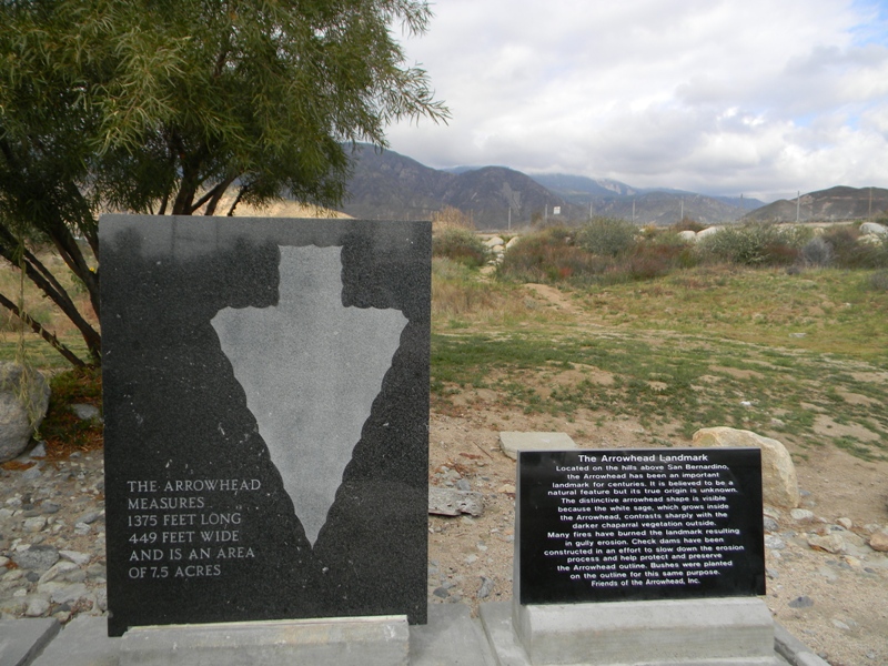
 On the way back, I stopped at the turnoff for "The Arrowhead" interpretive sign. I've seen the Arrowhead many times from a distance, but never stopped to read the official sign.
nobodyhikesinla says it's 6.2 miles roundtrip from CA-18 to Marshall Peak. With the short detour I took to check out a vista, I'll call it 6 1/4 miles for the day.


Cool video. I couldn't help imagining what it would be like to fly that thing over the city.
ReplyDeleteIt would be cool, and scary. I worry about silly things, like the laws of physics suddenly being suspended, and me plummeting to the ground!
ReplyDeleteThe neat thing is that most of the gliders floated a mile or two out, got over San Bernardino, found a thermal, circled and regained altitude, then swung around and landed back where they took off from. 20 minutes or so of flight time. A few of them rested a bit, then launched right back out there again.