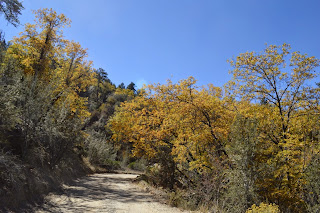
Hiked Sunday, October 5 and Sunday, October 12. I hiked this last week, but my camera battery was dead, so I have no pictures from that hike.
On that day, the leaves still had a fair amount of green, and it was before peak. But I figured this weekend would be past peak. If possible, mid-week would have been perfect.
I was correct. There were plenty of bare white skeletons of aspen this Sunday. But there was also still enough of the golden leaves of quaking aspen to make the sight an impressive one, particularly for those who may not have been here before.
By comparison, here's what it looked like a little over a year ago (sort of what it would have looked like last week, had I a functional battery in my camera), and here's what it looked like on my first visit to the aspen grove.
And, just for comparison, here's what it looks like when the aspen are green. You'll probably find some very comparable pictures from the other posts with the leaves golden.
It's probably too late to see much of a show this year, though, if you did want to see at least something, go *today*!
For future reference, if you visit, I would suggest some time around noon, or maybe a little after. That gets the sunlight more or less behind the main portion of the most easily accessible grove, which gives the great backlighting that makes the golden leaves really pop. Then again, I usually don't get an early enough start to reach the aspen grove much before 10 or 11am at the earliest. How it looks at sunrise, I can only guess. But I did notice that, by the time I left (2 or 2:30pm, the lighting had shifted enough to make some of the most photogenic areas appear just sort of normal.
Technic-ally, you need a wilderness permit to cross the creek into the San Gorgonio Wilderness area. I had one, because I'm a stickler for details. However, I would bet serious money that most folks visiting don't have it. Or, if they do, they must not read the provisions on the permit and the sign at the trailhead very carefully.
There were screaming kids (which annoys me, but does not surprise me) and screaming adults (which annoys me more, especially if they appear to be in their fifties or sixties). Kids were tossing logs and rocks all over the creek (which causes little if any actual harm, but does make the crossing steps less stable for future visitors).
To get to the trailhead, you take Interstate 10 (the San Bernardino Freeway to Highway CA-38, in Redlands. That's the Orange St. exit. Go straight at the first intersection off the freeway, then turn left at the second light (which is Orange). Take Orange north about four blocks, to Lugonia Avenue (that's still Highway 38, though the signage may not be immediately obvious to you). Stay on this route for nearly the entire rest of your trip.
Approxi-mately 18 miles east of Orange Street, you'll pass Bryant Street. Just after Bryant Street is the Mill Creek ranger station (USDA Forest Service). Stop there for your Wilderness Permit (free, but intended to provide a limitation on the number of visitors on any given day, so you can enjoy a modicum of solitude in the San Gorgonio Wilderness Area).
There's also a flush toilet at the ranger station, which is generally closed on Mondays and Tuesdays (hours and days vary by season).
From the ranger station, it's approximately 24.5 miles on CA-38 before you need to turn.
Take care to remain on CA-38, which involves a hairpin turn just a few miles up on CA-38, where a straight would take you off the highway and towards Forest Falls.
You'll then pass through Angeles Oaks, drive past Jenks Lake Road East, past Barton Flats, past Jenks Road, again, past the Santa Ana River trailhead, and past the Wildhorse trailhead.
Shortly after the road hits a straight-away and has a passing lane, look for signage on your right for a small road heading to Heartbar Ranch. The road dips down, becomes a dirt road, then continues another mile or so before reaching a fork. Take the right fork (towards Fish Creek). After another half-mile or so, the road crosses a creek and becomes quite narrow and steep. If you have a low-clearance vehicle, you probably want to park before that part of the road. High clearance vehicles will have no problem driving all the way to the trailhead. If you start your hike at the trailhead, it's about 1/4 mile to the aspen grove. If you start before the trail becomes narrow, it's another mile or so each way.
After crossing the river to the aspen grove, if you head right, there's another, larger aspen grove about 1/2 mile or so that way. You can't as easily become immersed in that grove, however. There's no easy trail that walks among them, and there's a lot of dead and down trees that make navigating that area very tricky.
Kenda Klever RT - One Year Review
-
TL;DR - The Kenda's have performed VERY well in all conditions (better than
the S/T Maxx) and have been a great tire. I'm trying to find a way to get
light...
3 days ago


No comments:
Post a Comment